Saltar al contenido principal

Trail la Osera

Submitted by brandcode_deweloper on
Id
4446222
Descripción larga

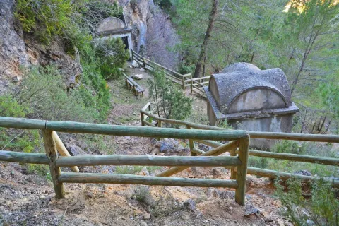
From Chilluévar take the mountain ridge towards the Embalse de Aguascebas. Continue on this road for the next 13.2 km. The beginning of the path is on the left according to the sense of progress. It is warned at the beginning of the path of the risk of stone falling. If we continue along that road we will find the Embalse of Aguascebas just under 300 meters.

Breve descripción

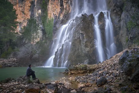
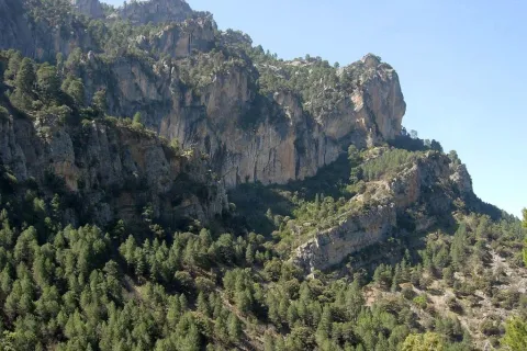
We find one of the most charming routes of the whole Sierra de las Villas. The Path of the Odera is located 18.600 Km east of Mogón within the Natural Park of Cazorla, Segura and Las Villas. Between large cut stone and valleys we will find a great wealth of flora (maple, boj, madroño, tejo, pinars, walnuts, oaks...) and fauna (golden vultures, eagles, hawks,...), as well as wonderful viewpoints from which we can observe unique landscapes.

Latitud
38.1804
Longitud
-2.6902
Municipio
Ubicación en el mapa
POINT (-2.6902 38.1804)
imagen
Image
la-osera-1-jpg
Imagen principal
Activado
imagen
Image
Sendero%20la%20Osera.jpg
Imagen principal
Desactivado
imagen
Image
la-osera-jpg
Imagen principal
Desactivado
4 h

Family

icon-intereses-familia

Friends

icon-intereses-amigos

Nature

icon-intereses-naturaleza

Adventure

icon-intereses-aventura

Solo travel

icon-intereses-viajar-solo

Culture

icon-intereses-cultura

Gastronomy

icon-intereses-gastronomia

Sport

icon-intereses-deporte

Municipality

icon-intereses-municipio

Low-cost tourism

icon-intereses-turismo-low-cost

Eco-friendly

icon-intereses-eco-friendly

For couples

icon-intereses-en-pareja
Alta
Sendero la Osera
4 km
On foot
All year round
Desactivado

Wear clean water and adequate clothing and footwear. Solar protection in the summer

The route begins by surrounding the reservoir of the Aguascebas from which we can observe the majestic peak of Navazalto at the front until we reach the enclave known as the passage of the Acuardo all of it surrounded by large pineas. From here we will continue to descend gradually through the valley of La Osera until we reach a viewpoint where we can see part of the region of Las Villas as well as the passage of the great protagonist of this valley as is the river Aguascebas Chico.

Bike Route Mirabuenos - Los Centenares

Submitted by brandcode_deweloper on
Id
2851244
Descripción larga

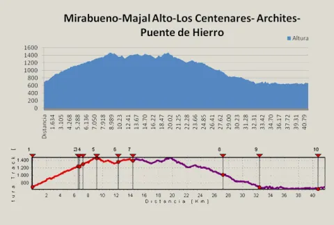
We can refresh at the Fountain del Roble, which gives name to the initial area, and arrive at the crossing of the road to the Archites, in the km. 6.7, we'll have to turn right at first to do a round-trip. Then, when we return, we will continue our route on the left. The linear section has great attractions, as it is an old vulture feeder located in the km. 7.2, or the Majal Alto watch house with stunning views of the whole of the Banderillas and the Guadalquivir Valley (km. 9.1). Once crowned Majal Alto and after a brief descent we will continue to ascend to the village of Las Canalejas and then to Los Centenares, two of the populations that were uninhabited with the creation of the National Cazorla and Segura Coto in the year 1,960.

From the Centenars we start the return on the same way out until we reach the km. 4.6, where we took the track of the Archites, another of the cords inhabited in its day, where they also took advantage of the nearest land to grow all kinds of cereals, and which have now become mostly forest land.

Finally continuing the track in continuous descent we reach the edge of the Embalse del Tranco, just opposite the Island of Cabeza de la Viña, in the area known as the Iron Bridge. We turn there to the left to line the reservoir. We will leave to our right the ruins of the castle of Bujaraiza and the plain of the same name, well known as the stage of the berrea, the fighting that takes place every year in September among the great deer males in their time of zeal. Finally we arrive at the Mirabueno view over the Guadalquivir River and just 300 m. to the starting place.

Breve descripción

The tour begins on the road to the Cuesta de Mirabueno, on the Llanos de Arance track, and has a linear round and round section and a circular. The route starts at 4.6 km. on the A-319 road, right on a closed track left on our right. This track, in continuous rise, enters us by the three types of pine trees that exist in the Park (carrasco, black and laricio pines) as we gain altitude, but we must highlight the magnificent forest of burning that we go through at half climb.

Latitud
38.0803
Longitud
-2.6201
Distrito
Municipio
Ubicación en el mapa
POINT (-2.6201 38.0803)
imagen
Image
_MG_0793.JPG
Imagen principal
Activado
imagen
Image
Ruta%20en%20bici%20Mirabuenos%20-%20Los%20Centenares.jpg
Imagen principal
Desactivado
imagen
Image
Ruta%20en%20bici%20Mirabuenos%20-%20Los%20Centenares2.jpeg
Imagen principal
Desactivado

Nature

icon-intereses-naturaleza

Friends

icon-intereses-amigos

Adventure

icon-intereses-aventura

Culture

icon-intereses-cultura

Sport

icon-intereses-deporte

Eco-friendly

icon-intereses-eco-friendly

For couples

icon-intereses-en-pareja

Family

icon-intereses-familia

Gastronomy

icon-intereses-gastronomia

Municipality

icon-intereses-municipio

Low-cost tourism

icon-intereses-turismo-low-cost

Solo travel

icon-intereses-viajar-solo
638 m.
CAMINO DE MIRABUENO A LOS CENTENARES
42,1 km
1938m
1941m
In Bicycle, Horse, on foot
All year round
Desactivado
Image
5256dc0f-573d-f9f4-529f-9cda9ae7e6c8?t=1589472588230

Plains of arance.

From the road A-319 we will take the detour to Llanos de Arance and continue the entrance track to the Camping la JF-7099. Our route will begin on the second track we find to the right.

681 m.

The village of Los Centenares

1.171 m.
Coordenadas / Huso 30S
30S = 516047 and = 4214438
Tramo de asfalto o cemento
0
Tramo de pista o camino forestal
0.01
Tramo de vía pecuaria
0
Tramo de senda
0

Circular Route Campos de Hernán Pelea

Submitted by brandcode_deweloper on
Id
2819129
Descripción larga

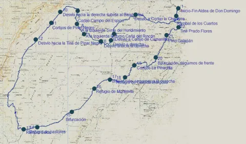
We must take the track that begins next to the Forest House of Don Domingo, in the direction of the Rambla, 1.5 km. We got to it. It is a stream that occasionally carries water, but that shows great avalanches in times of growth, before crossing it, we will have to take to the right a track that goes parallel to this stream. It is a breeding area par excellence, so along the route we will find flocks of Segureña sheep, tornajos (abrevaderos) for water and large pastures splattered with larice pines in some areas, black retama in others and graceful.

In the km. 5.5 We find a fork, to the right the track leads to the Chaparra Cortijos, we follow to the front. Later, in the km. 7.5 We find another right-hand detour, this one to access the Camarillas Cortijos, and we also follow the front.

At 8.4 km. We get to another crossing and here we have to turn right and at 600 m we will find again another crossing that we will have to follow right. Before the same we will also have left a secondary track to the right.

In the km. 11.5 We left to our left another track to access the herdsmen 'shelter of the Rincón Canyon. Our track is going up little by little, and almost 500 meters later we must leave it, to continue for a less busy that goes left. Right at this point and just 200 m to our left, there is a very striking dolina, as it has almost perfect funnel shape. Soon we passed through a hill and began a sharp descent towards a large plains that make up the Campo del Espino. In front we see the Banners peak and right in front of a forest mass that corresponds to the Pinar Negro estate, which we will travel from this moment on. In the km. 13 We left to our left the Cortijo del Campo del Espino, moving at this moment to the right, to border the forest mentioned above and to turn to the left, later to the Banderillas. We left to our right a peeled hill of trees that is the Majal de la Carrasca.

15.2 km. We left to the right a secondary track that we could access to the top of the Banderillas, we followed to the front and a few 1.3 km. We left to the right the Black Pinar Cortijos, which have a pebble. The tour at this time and for several km more runs through the base of the Banderillas that remains to our right and to our left infinity of dolinas, with rocks, pine and large pastures.

In the km. 18 We find a fork that we will have to follow to the right, the left track goes to the black Pinar Tina and we could also go through it to the Black Pinar Sima, a vertical oquity of several hundred meters of galleries.

From this moment on, we will go through the area known as the Charcones, very rich in fauna, and closed to the traffic of motor vehicles, so the observation of fauna is very common. We are coming down, but soon the track begins to rise to the steep crests of the Risco and the Halt of Hell, to return to Ramblaseca.

When we get to Rambla Seca we will take a little more than 28 km. Here we will find a herdsman's shelter and a water-filled work-room. To continue our route we must turn left and continue the main track. To the right is the old control of Rambla Seca.

From here it is difficult to get lost, as long as we maintain our criterion of following the most busy track, in the km. 31.5 we'll leave a new forest track to the left, and in km. 35 the Refuge of Monterilla. 1.7 km. On the same side again, we left another track to the left and soon arrived at the Cañada Mercosa Refuge.

At the height of the km. 39, the landscape begins to change, with some larity pines appearing and soon, 500 m away, we left the Pinadilla Cortijos to the left. Later on in the km. 42 We shall leave to the right the track that goes towards the fourth of the Pinar. We continue to the front on the right side of the Arroyo del Juan Fría. Very soon, on our left, we began to see some examples of larice of extraordinary dimensions. On the other side of the stream, in the km. 44.2, is the Pino Galapán, the highest of the larices of the entire Park.

Then we must follow our track, which begins a small climb, on a small hill we leave the Tina Prado Flores to the left and in the km. 47 We arrived again at the Rambla de los Cuartos, which we saw at the beginning. Now we will cross it, to return along the same path that we initially traveled to the village of Don Domingo.

Breve descripción

The tour takes place on the large kartic platform of the Campos de Hernán Pelea, altiplanicie located between 1,600 to 1,700 m of altitude, and is the largest reserve of underground water in the entire Natural Park Sierras de Cazorla, Segura and Las Villas. It is a circular route that begins in the village of Don Domingo, which can be reached by asphalt road, from the core of Santiago de la Sword.

Latitud
38.01781
Longitud
-2.652742
Distrito
Municipio
Ubicación en el mapa
POINT (-2.652742 38.01781)
imagen
Image
IMG_1218%20copia.jpg
Imagen principal
Activado
imagen
Image
Campos-Hern%C3%A1n-Perea.jpg
Imagen principal
Desactivado
imagen
Image
Campos-Hern%C3%A1n-Perea2.jpg
Imagen principal
Desactivado

Nature

icon-intereses-naturaleza

Friends

icon-intereses-amigos

Adventure

icon-intereses-aventura

Culture

icon-intereses-cultura

Sport

icon-intereses-deporte

Eco-friendly

icon-intereses-eco-friendly

For couples

icon-intereses-en-pareja

Family

icon-intereses-familia

Gastronomy

icon-intereses-gastronomia

Municipality

icon-intereses-municipio

Low-cost tourism

icon-intereses-turismo-low-cost

Solo travel

icon-intereses-viajar-solo
1,574 m.
Image
2e51fc1f-48d2-c7a4-5341-bfd8e4df99c9?t=1589390356114
CIRCULAR CAMPOS DE HERNÁN PELEA
48,22 km
852m
836m
All year round
Desactivado
Image
412bc72d-44fe-fef2-95e7-c6dd431279e2?t=1589390318542

Village of Don Domingo

_

1.544 m.

Village of Don Domingo

1.544 m.
Coordenadas / Huso 30S
30S x = 530481 and = 4207848
Tramo de asfalto o cemento
0.01
Tramo de pista o camino forestal
0
Tramo de vía pecuaria
0
Tramo de senda
0