Saltar al contenido principal

Hiking Route Río Borosa

Submitted by brandcode_deweloper on
Id
5727693
Descripción larga


This hiking route is, of course, the most popular route in the Natural Park, which also implies the possibility of a certain massification at a short time. The set formed by the fast waters of the Borosa, the rocks in which the channel is fit and the closed riverside vegetation, is one of the most spectacular river scenarios in southern Spain.
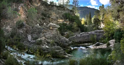
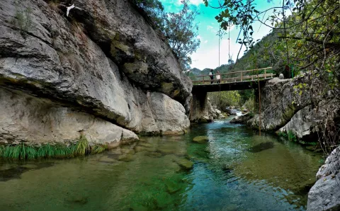
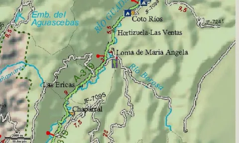
To start the route we go to the Visitors' Reception Centre of the Torre del Vinagre, in the Carrier A-319, and we take a detour to the River Borosa River River River River River River. The path begins right from the farm next door.

At first, the tour goes through a closed forest track to the traffic of private vehicles that always goes parallel to the river's path, being one of the most pleasant walks that can be made in the Natural Park, especially in its initial section.

At first it coincides with the route of GR 7, up to the bridge of the Snails where we leave this Grand Tour, to continue parallel to the Borosa River. In the km 3.3 we left the track on which we went to the left to continue by the river, along the path and through the Cerrada de Elias, a rocky cling of the channel, full of clear and cold waters. Later on we go back to the track we were initially going through, to continue upstream on either side of the river until we reach the Hydroelectric Central of the Organs where the track ends.

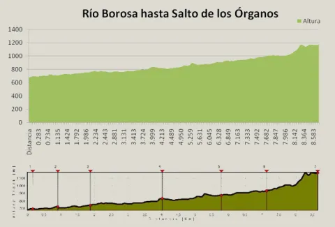
Here begins a sinuous path with much more slope next to a much more tight, rocky and abrupt channel, full of spectacular water jumps. And it ends the tour in the organ jump, without a doubt one of the most spectacular waterfalls in the entire park. It is said that its name is due to the noise that, in past times, they did when the logs that were taken from these mountains fell through these water jumps.

Most of the tour runs along the edge of one of the Park Reserve Areas, an area with the highest level of protection due to the ecological values it houses. The Borosa River, along its 10 km, is one of the most cuddly tributaries of Guadalquivir within the Park. It is born at the base of the large underground aquifer that forms the altiplanicie of the fields of Hernán Perea, hence its annual flow and regularity. It is important to highlight in its channel several Cerradas that make up a spectacular landscape, continuous water jumps and pozas and a very good state of conservation of the channel, maintaining crystal clear and cold waters, with abundant fauna and lush riverside vegetation. This tour also offers us a true lesson in geology, with striking, sincere and anti-linear folds that are easily observed.

Breve descripción

This hiking route is, of course, the most popular route in the Natural Park, which also implies the possibility of a certain massification at a short time. The set formed by the fast waters of the Borosa, the rocks in which the channel is fit and the closed riverside vegetation, is one of the most spectacular river scenarios in southern Spain.

Latitud
37.969693
Longitud
-2.818145
Distrito
Municipio
Ubicación en el mapa
POINT (-2.818145 37.969693)
imagen
Image
Rio%20Borosa%201.jpg
Imagen principal
Desactivado
imagen
Image
Rio%20Borosa%202.jpg
Imagen principal
Desactivado
2 h 10 min

Nature

icon-intereses-naturaleza

Friends

icon-intereses-amigos

Adventure

icon-intereses-aventura

Culture

icon-intereses-cultura

Sport

icon-intereses-deporte

Eco-friendly

icon-intereses-eco-friendly

For couples

icon-intereses-en-pareja

Family

icon-intereses-familia

Gastronomy

icon-intereses-gastronomia

Municipality

icon-intereses-municipio

Low-cost tourism

icon-intereses-turismo-low-cost

Solo travel

icon-intereses-viajar-solo
Medium
1175
Document
Image
2ec036ff-ad31-ddd2-4b7f-81e7f2ac7e60?t=1607087625599
Document
Image
99f458a1-40f7-f2ca-ce5e-e777b5a80749?t=1607086468943
RÍO BOROSA A SALTO DE LOS ÓRGANOS
8,92 km
619m
143m
3
1
2
2
In Bicycle, Horse, on foot
All year round
Desactivado
Image
e57eeca2-fdbd-8aef-bbab-3a9084d4b61f?t=1607087616696

Badén and Los Rodeos Bridge

In its initial route that coincides with the GR 7 that separates from our route on the Bridge of the Snails, the path can be continued towards the Embalse of Aguas Negras and Laguna de Valdeazores crossing the tunnels, from the Jump of the Organs.

Access to the village of Loma de Mariangela, from the Interpretation Centre of the Vinagre Tower in the A 319, at the height of the farm and the River Borosa River River River River River River.

681 m

Leap from the bodies

1171 m
Coordenadas / Huso 30S
30S x = 515973 and = 4202468
Tramo de asfalto o cemento
0
Tramo de pista o camino forestal
71.75%
Tramo de vía pecuaria
0
Tramo de senda
28.28%

Hiking Route Montillana - Risca del Guijarrón

Submitted by brandcode_deweloper on
Id
5726925
Descripción larga

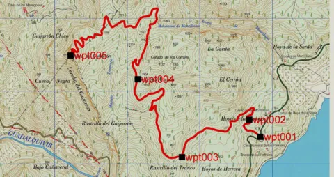
The beginning of the path is on the road on the A 319 between Cañada Morales and the Tranco dam, just above the Recreative Area of the Parrales and between the Camping Montillana and the Casa Rural Los Parrales just 200 m from both.

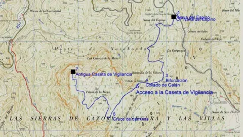
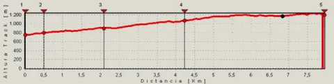
The route runs through a forest track usually closed to the traffic of vehicles, which ascends by the skirts of the Guijarrón, the final objective of the route. It has very panoramic sections, with excellent views of the Tranco reservoir, initially of the Horn tail and later of its most central area.

In the km 2,2 we find a fountain and a watershed that will allow us to supply for the rest of the tour. In the km 6.6 we will find a link to GR 144, Path of Trashumancia. Through this route we could return to Cañada Morales and from there, through the PR-A 193, return to our starting point, resulting in a circular tour of 27 km.

The final point of our route to the Guijarrón is the fire surveillance shelter, which rises on a cliff with spectacular views of the Tranco reservoir and large views of the Natural Park.

In the lower areas of the route we will pass through pineapple carrasco, which are becoming pineapple pineapple as we are gaining height. Under the pine tree grows a characteristic Mediterranean forest.

Breve descripción

The beginning of the path is on the road on the A 319 between Cañada Morales and the Tranco dam, just above the Recreative Area of the Parrales and between the Camping Montillana and the Casa Rural Los Parrales just 200 m from both.

Latitud
38.195088
Longitud
-2.803527
Distrito
Municipio
Ubicación en el mapa
POINT (-2.803527 38.195088)
imagen
Image
518_img.png
Imagen principal
Activado
imagen
Image
shutterstock_1060474277.jpg
Imagen principal
Desactivado
2 h 33 min (solo ida)

Nature

icon-intereses-naturaleza

Friends

icon-intereses-amigos

Adventure

icon-intereses-aventura

Culture

icon-intereses-cultura

Sport

icon-intereses-deporte

Eco-friendly

icon-intereses-eco-friendly

For couples

icon-intereses-en-pareja

Family

icon-intereses-familia

Gastronomy

icon-intereses-gastronomia

Municipality

icon-intereses-municipio

Low-cost tourism

icon-intereses-turismo-low-cost

Solo travel

icon-intereses-viajar-solo
Medium
Km. (from the beginning): 7.96
Image
5c3a9437-f5d2-438e-a307-cf3fea310c37?t=1607099424256
Image
74cbf89e-c5e1-8d5b-4719-2efb97b2984e?t=1607099411570
MONTILLANA- RISCA DEL GUIJARRÓN
7,96 km
602m
135m
2
1
1
2
Bicycle, Horse, walk, and all terrain.
All year round
Desactivado
Image
2f474108-5cf8-cc9c-4933-397d5be85a3a?t=1607099405218

RECREATIVE AREA THE PARRALES IN THE INITIUM

319 between the village of Cañada Morales and the Tranco dam. 100 m from Campsite Montillana.

748 m

Gear Risk Summit

1232 m
Coordenadas / Huso 30S
30 x = 0517204 and = 4227479 Z = 1232
Tramo de asfalto o cemento
0
Tramo de pista o camino forestal
98.74%
Tramo de vía pecuaria
0
Tramo de senda
1.26%