
Route Source of the River Segura – Viewpoint Juan León
Attention to snow in winter and contrast of temperatures between day and night in summer.
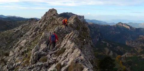
After contemplating at the beginning the great poza where the Segura river is born, the route ascends between pinars, pastures, small vaguadas and very broken hills by the karmic action.
The route ends in an impressive cut from which we discover the most panoramic. To the left, the rope of the Banderillas and the Sierra de Cazorla. To the right stands the summit of the Yelmo and the Alcaraz Albaceteña saw.
The most immediate thing is the abandoned village of Los Centenares. After that, the summit curtain of the Sierra de Mirabuenos and the Sierra de las Villas, among which the Guadalquivir valley and the Tranco reservoir are hidden. Beyond, the view is lost in the plains of Castilla-La Mancha. The area is continuously overflown by leonate vultures and the muflon is very abundant.


Pontones has various services and at the birth of the Segura there is a recreational area with banks and tables. There are no sources on the tour.
Recreative area of the Birth of the Segura, located at the end of the above mentioned road, which is 4.7 km long
On the road JF-7047, which leaves 0.5 km from Pontones (Pontón Bajo) towards Santiago de la Sword, to the right, with the indication "Fuente Segura."
Recreative area of the Birth of the Segura, located at the end of the above mentioned road, which is 4.7 km long.
