
Saltar al contenido principal

Route Source of the River Segura – Viewpoint Juan León

Submitted by brandcode_deweloper on
Id
5971858
Descripción larga

Attention to snow in winter and contrast of temperatures between day and night in summer.

Breve descripción

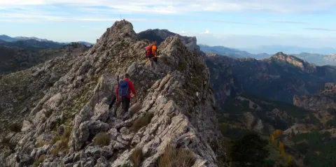
After contemplating at the beginning the great poza where the Segura river is born, the route ascends between pinars, pastures, small vaguadas and very broken hills by the karmic action.

The route ends in an impressive cut from which we discover the most panoramic. To the left, the rope of the Banderillas and the Sierra de Cazorla. To the right stands the summit of the Yelmo and the Alcaraz Albaceteña saw.

The most immediate thing is the abandoned village of Los Centenares. After that, the summit curtain of the Sierra de Mirabuenos and the Sierra de las Villas, among which the Guadalquivir valley and the Tranco reservoir are hidden. Beyond, the view is lost in the plains of Castilla-La Mancha. The area is continuously overflown by leonate vultures and the muflon is very abundant.
Latitud
38.0001
Longitud
-2.7503
Distrito
Municipio
Ubicación en el mapa
POINT (-2.7503 38.0001)
imagen
Image
2.jpg
Imagen principal
Activado
imagen
Image
Ruta%20Nacimiento%20del%20R%C3%ADo%20Segura%20%E2%80%93%20Mirador%20de%20Juan%20Le%C3%B3n.jpg
Imagen principal
Desactivado
1 h 45 min (solo ida)

Nature

icon-intereses-naturaleza

Friends

icon-intereses-amigos

Adventure

icon-intereses-aventura

Culture

icon-intereses-cultura

Sport

icon-intereses-deporte

Eco-friendly

icon-intereses-eco-friendly

For couples

icon-intereses-en-pareja

Family

icon-intereses-familia

Gastronomy

icon-intereses-gastronomia

Municipality

icon-intereses-municipio

Low-cost tourism

icon-intereses-turismo-low-cost

Solo travel

icon-intereses-viajar-solo
Medium
Ruta Nacimiento del Río Segura – Mirador de Juan León
5,6 km (solo ida)
317m
All year round
Desactivado

Pontones has various services and at the birth of the Segura there is a recreational area with banks and tables. There are no sources on the tour.

Recreative area of the Birth of the Segura, located at the end of the above mentioned road, which is 4.7 km long

On the road JF-7047, which leaves 0.5 km from Pontones (Pontón Bajo) towards Santiago de la Sword, to the right, with the indication "Fuente Segura."

Recreative area of the Birth of the Segura, located at the end of the above mentioned road, which is 4.7 km long.
Route Reservoir las Anchuricas

Submitted by brandcode_deweloper on
Id
5966065
Descripción larga

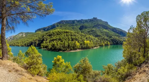
This path coincides throughout its journey with the PR-A 128 Circular Embalse of Anchuricas, which has a total distance of 14 km. And it's marked with stone mojones. It also coincides with the path marked by the Environmental Council, so the distances will not exactly be with those we see in the starting panel.

Breve descripción

In the heart of the Segura River Valley, in the municipal term of Santiago- Pontones.

Latitud
38.0803
Longitud
-2.6001
Distrito
Municipio
Ubicación en el mapa
POINT (-2.6001 38.0803)
imagen
Image
embalse-anchuricas-jpg
Imagen principal
Activado
imagen
Image
Imagen principal
Activado
imagen
Image
embalse-anchuricas-1-jpg
Imagen principal
Desactivado
1 h 30 min (solo ida)

Family

icon-intereses-familia

Friends

icon-intereses-amigos

Nature

icon-intereses-naturaleza

Adventure

icon-intereses-aventura

Solo travel

icon-intereses-viajar-solo

Culture

icon-intereses-cultura

Gastronomy

icon-intereses-gastronomia

Sport

icon-intereses-deporte

Municipality

icon-intereses-municipio

Low-cost tourism

icon-intereses-turismo-low-cost

Eco-friendly

icon-intereses-eco-friendly

For couples

icon-intereses-en-pareja
Baja
Document
Document
Document
Ruta Embalse de las Anchuricas
5,7 km
265m
330m
All year round
Desactivado

It is a short path without difficulty with exceptional views throughout the course that allow numerous stops; but we certainly recommend the one indicated in the second point of the description.

Right next to the birth in the Toba, by the track that comes from the water tank.

To get to La Toba we must travel the JF-7038 that goes from Navalhora to the Juntas through the valley of the Segura River. There is a small asphalt detour from the same that goes to the village of La Toba.

Tramo de asfalto o cemento
0
Tramo de pista o camino forestal
0.01
Tramo de vía pecuaria
0
Tramo de senda
0
