Saltar al contenido principal

Circular Route Campos de Hernán Pelea

Submitted by brandcode_deweloper on
Id
2819129
Descripción larga

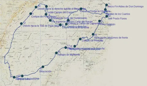
We must take the track that begins next to the Forest House of Don Domingo, in the direction of the Rambla, 1.5 km. We got to it. It is a stream that occasionally carries water, but that shows great avalanches in times of growth, before crossing it, we will have to take to the right a track that goes parallel to this stream. It is a breeding area par excellence, so along the route we will find flocks of Segureña sheep, tornajos (abrevaderos) for water and large pastures splattered with larice pines in some areas, black retama in others and graceful.

In the km. 5.5 We find a fork, to the right the track leads to the Chaparra Cortijos, we follow to the front. Later, in the km. 7.5 We find another right-hand detour, this one to access the Camarillas Cortijos, and we also follow the front.

At 8.4 km. We get to another crossing and here we have to turn right and at 600 m we will find again another crossing that we will have to follow right. Before the same we will also have left a secondary track to the right.

In the km. 11.5 We left to our left another track to access the herdsmen 'shelter of the Rincón Canyon. Our track is going up little by little, and almost 500 meters later we must leave it, to continue for a less busy that goes left. Right at this point and just 200 m to our left, there is a very striking dolina, as it has almost perfect funnel shape. Soon we passed through a hill and began a sharp descent towards a large plains that make up the Campo del Espino. In front we see the Banners peak and right in front of a forest mass that corresponds to the Pinar Negro estate, which we will travel from this moment on. In the km. 13 We left to our left the Cortijo del Campo del Espino, moving at this moment to the right, to border the forest mentioned above and to turn to the left, later to the Banderillas. We left to our right a peeled hill of trees that is the Majal de la Carrasca.

15.2 km. We left to the right a secondary track that we could access to the top of the Banderillas, we followed to the front and a few 1.3 km. We left to the right the Black Pinar Cortijos, which have a pebble. The tour at this time and for several km more runs through the base of the Banderillas that remains to our right and to our left infinity of dolinas, with rocks, pine and large pastures.

In the km. 18 We find a fork that we will have to follow to the right, the left track goes to the black Pinar Tina and we could also go through it to the Black Pinar Sima, a vertical oquity of several hundred meters of galleries.

From this moment on, we will go through the area known as the Charcones, very rich in fauna, and closed to the traffic of motor vehicles, so the observation of fauna is very common. We are coming down, but soon the track begins to rise to the steep crests of the Risco and the Halt of Hell, to return to Ramblaseca.

When we get to Rambla Seca we will take a little more than 28 km. Here we will find a herdsman's shelter and a water-filled work-room. To continue our route we must turn left and continue the main track. To the right is the old control of Rambla Seca.

From here it is difficult to get lost, as long as we maintain our criterion of following the most busy track, in the km. 31.5 we'll leave a new forest track to the left, and in km. 35 the Refuge of Monterilla. 1.7 km. On the same side again, we left another track to the left and soon arrived at the Cañada Mercosa Refuge.

At the height of the km. 39, the landscape begins to change, with some larity pines appearing and soon, 500 m away, we left the Pinadilla Cortijos to the left. Later on in the km. 42 We shall leave to the right the track that goes towards the fourth of the Pinar. We continue to the front on the right side of the Arroyo del Juan Fría. Very soon, on our left, we began to see some examples of larice of extraordinary dimensions. On the other side of the stream, in the km. 44.2, is the Pino Galapán, the highest of the larices of the entire Park.

Then we must follow our track, which begins a small climb, on a small hill we leave the Tina Prado Flores to the left and in the km. 47 We arrived again at the Rambla de los Cuartos, which we saw at the beginning. Now we will cross it, to return along the same path that we initially traveled to the village of Don Domingo.

Breve descripción

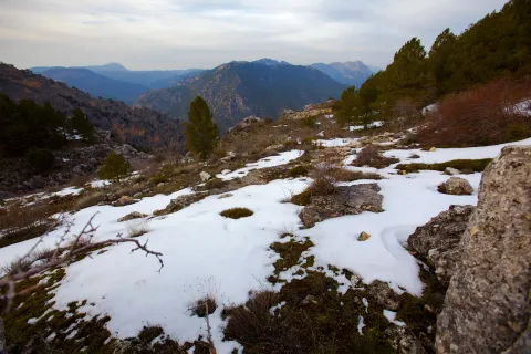
The tour takes place on the large kartic platform of the Campos de Hernán Pelea, altiplanicie located between 1,600 to 1,700 m of altitude, and is the largest reserve of underground water in the entire Natural Park Sierras de Cazorla, Segura and Las Villas. It is a circular route that begins in the village of Don Domingo, which can be reached by asphalt road, from the core of Santiago de la Sword.
Latitud
38.01781
Longitud
-2.652742
Distrito
Municipio
Ubicación en el mapa
POINT (-2.652742 38.01781)
imagen
Image
IMG_1218%20copia.jpg
Imagen principal
Activado
imagen
Image
Campos-Hern%C3%A1n-Perea.jpg
Imagen principal
Desactivado
imagen
Image
Campos-Hern%C3%A1n-Perea2.jpg
Imagen principal
Desactivado

Nature

icon-intereses-naturaleza

Friends

icon-intereses-amigos

Adventure

icon-intereses-aventura

Culture

icon-intereses-cultura

Sport

icon-intereses-deporte

Eco-friendly

icon-intereses-eco-friendly

For couples

icon-intereses-en-pareja

Family

icon-intereses-familia

Gastronomy

icon-intereses-gastronomia

Municipality

icon-intereses-municipio

Low-cost tourism

icon-intereses-turismo-low-cost

Solo travel

icon-intereses-viajar-solo
1,574 m.
Image
2e51fc1f-48d2-c7a4-5341-bfd8e4df99c9?t=1589390356114
CIRCULAR CAMPOS DE HERNÁN PELEA
48,22 km
852m
836m
All year round
Desactivado
Image
412bc72d-44fe-fef2-95e7-c6dd431279e2?t=1589390318542

Village of Don Domingo

_

1.544 m.

Village of Don Domingo

1.544 m.
Coordenadas / Huso 30S
30S x = 530481 and = 4207848
Tramo de asfalto o cemento
0.01
Tramo de pista o camino forestal
0
Tramo de vía pecuaria
0
Tramo de senda
0

Route Gil Cobo - Fuente Colorá

Submitted by brandcode_deweloper on
Id
2813220
Descripción larga

The path begins in the recreational area and camp of Gil-Cobos by the right margin of the stream of the Aguascebas, up the secondary forest track that exists there in a southeast direction. At 800 m from the beginning we find one of the most beautiful areas of this tour, the Cerrada de San Ginés, a vertical setting of rocky lanterns formed by the Lobo's Locks on the left, and the Escalera's boat on the right, which is surrounded by deciduous forests, pinars, and riparian and rupic communities.

At the end of it, where the stream is divided into two, the track is also divided and we will have to turn right according to the direction of the march, to continue a steep rise in its first meters; after a sharp curve we find a source of work with some stone tables, it is Fountain Colorá, at 2.1 km. From the beginning. 600 meters later we find on our left a shop, it is Majalserbal, which is raised on the beautiful and agribusiness boat Ignacio. The other boat, which falls from the ink to the beginning of the Cerrada de San Ginés, has the name "Lancha del Sordo."

After walking 4.4 km. We got to a collar. We are at the top of the Stairboat. The Poyo of the Robles is what is also called all this land. Large panorama of the lome of Ubeda with several well-visible villages and the massif of Sierra Magina. We are close to 1,600 m of altitude and vegetation is characteristic of the high mountain of the Park, piornal and other small-scale, arbustive and thorny plants, as well as herring, larice pines and some oaks.

This area will be the highest of our journey, as from here we begin to descend. The track tracks several curves with firm formed of loose stones and quite bumpy until it enters the flat lands of Jabalhora. A unique karctic landscape that will accompany us until the end of our journey. We found several streams on its highest side, such as Arroyo del Raso de la Escalera and Arroyo de la Fuente del Tejo, and in the km. 6.7 and also a jungle with water called the Fuentecilla of the Vultures.

Later, in the km. 8.2, we left a track to the left, which is directed to other cortijadas in the Avellano Canyon or Jabalhora cortijos also called. We will continue to the left to find in the km. 8.8 The cords of the Berraza, where there is a source. From this moment on the firm becomes more difficult and begins to turn right to leave Peña Corba to our left.

At 11.3 km. We got to the Pardal Cortijos. It is recommended to climb to the peak on foot, as with its 1.578 m., it offers a wide view of the area. The return will be on the same way out.

Breve descripción

If you access from Chilluévar and about 8 km away. after passing the reservoir of the Aguascebas, in the km. 28, there is a secondary forest track or road that leaves to the right of the road, just where it crosses the Arroyo de las Aguascebas de Gil Cobo, beginning of the route.

Latitud
38.032722
Longitud
-2.904077
Municipio
Ubicación en el mapa
POINT (-2.904077 38.032722)
imagen
Image
_MG_3292.JPG
Imagen principal
Activado
imagen
Image
PANTANO2.jpg
Imagen principal
Desactivado
imagen
Image
Sierra%20de%20las%20Villas.%20Vva.%20del%20Arzobispo%20%28Ja%C3%A9n%29.JPG
Imagen principal
Desactivado

Nature

icon-intereses-naturaleza

Friends

icon-intereses-amigos

Adventure

icon-intereses-aventura

Culture

icon-intereses-cultura

Sport

icon-intereses-deporte

Eco-friendly

icon-intereses-eco-friendly

For couples

icon-intereses-en-pareja

Family

icon-intereses-familia

Gastronomy

icon-intereses-gastronomia

Municipality

icon-intereses-municipio

Low-cost tourism

icon-intereses-turismo-low-cost

Solo travel

icon-intereses-viajar-solo
1,474 m.
Campamento de Gil Cobo a Cortijos del Pardal
11,3 km (solo ida)
476m
279m
All year round
Desactivado
Image
3698f04f-cd07-22ba-8591-6d952821430c?t=1589388090540

We can also access the beginning from the oil puddle.

1.178 m.

Itinerary: GIL COBO - SAN GIN CERRADA - SCALERA LANCH - JABALCABEL CLANES - PARDAL CORTIJO

1.178 m.
Coordenadas / Huso 30S
30S x = 508418 and = 4209450
Tramo de asfalto o cemento
0
Tramo de pista o camino forestal
0.01
Tramo de vía pecuaria
0
Tramo de senda
0