Saltar al contenido principal

Iglesia de San Pedro y San Pablo

Submitted by brandcode_deweloper on
Id
4528305
Descripción
Descripción larga
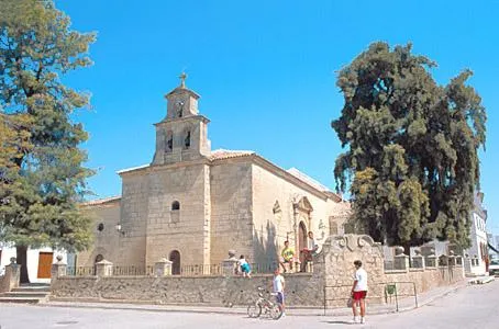
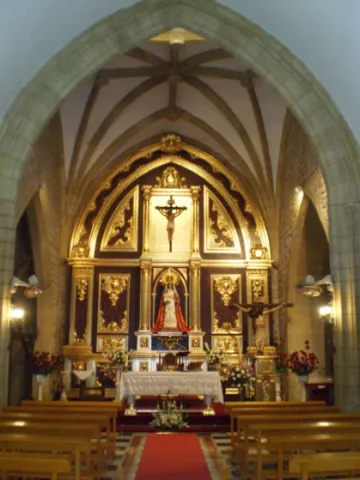
It has a single-nave floor plan with chapels set between the buttresses, not connected to one another. The vault of the central nave is a barrel vault, resting on transverse arches which in turn rest on beautiful pilasters. The main chapel is preceded by a large arch bearing the coat of arms of Bishop Don Antonio Brizuela y Salamanca. The presbytery is covered by an interesting pseudo-oval dome on pendentives, built in the 17th century. At the foot of the church stands the raised choir, supported by two columns, and the bell tower. The original main altarpiece, of which only the attic section survives intact, is a Baroque work, also completed in the second half of the 17th century, though gilded in 1737 by the master craftsmen Manuel Pancorbo and Antonio Clavijo. It shows a three-section structure divided by Solomonic columns, with an attic section housing an image of Christ Crucified. This church has seven side chapels, traditionally linked to particular families. During the Civil War, the original altarpieces disappeared, along with the rich collection of religious imagery from its altars. • Chapel of San José • Chapel of Nuestra Señora de los Dolores • Chapel of San Antonio • Chapel of María Auxiliadora • Chapel of the Souls (Ánimas) • Chapel of the Veracruz • Chapel of the Señor de la Columna
Breve descripción
This church was commissioned by Francisco Sarmiento de Mendoza, Bishop of Jaén, in 1523, who had it built in its entirety, including images, altarpieces and bells.
Ubicación
Latitud
38.02291
Longitud
-3.50205
Dirección
Calle Iglesia, 1
Municipio
Ubicación en el mapa
POINT (-3.50205 38.02291)
Tipos de punto de interés
Imágenes carrusel
imagen
Image
Iglesia%20de%20San%20Pedro%20y%20San%20Pablo2.jpeg
Imagen principal
Desactivado
Imágenes cabecera
imagen
Image
Iglesia%20de%20San%20Pedro%20y%20San%20Pablo.jpg
Imagen principal
Activado
Loading map
Preparing points of interest and routes...

Ermita del Santo Cristo de la Salud

Submitted by brandcode_deweloper on
Id
3964271
Descripción
Descripción larga
The popular veneration of the titular Christ is linked to a deadly plague epidemic that devastated the town in 1833, which subsided after residents agreed to carry the image of the Crucified Christ in procession, after which the epidemic receded and the sick recovered. In thanksgiving, the hermitage was remodelled, its features of interest being the ashlar semicircular-arched doorway and the single-tier bell gable, and the dedication of its titular image was changed.
Breve descripción
Outside the town walls, the hermitage of Santa Ana was built between the 16th and 17th centuries, using stones from the Iberian ruins of Maquiz; it was converted at the end of the 19th century into the hermitage of the Santo Cristo de la Salud.
Telecomunicaciones
Sitio web
http://www.parroquiavillargordo.es/
Teléfono de contacto
953 37 70 00
Ubicación
Código Postal
23630
Latitud
37.94571
Longitud
-3.73042
Dirección
C/ 14 de Abril s/n
Municipio
Ubicación en el mapa
POINT (-3.73042 37.94571)
Tipos de punto de interés
Imágenes carrusel
imagen
Image
Ermita%20del%20Santo%20Cristo%20de%20la%20Salud.png
Imagen principal
Desactivado
Imágenes cabecera
imagen
Image
MG_9427.jpg
Imagen principal
Activado
Loading map
Preparing points of interest and routes...

La Ermita de la Virgen de Atocha

Submitted by brandcode_deweloper on
Id
4521662
Descripción
Descripción larga
Around the 18th century, the hermitage of the Virgen de Atocha was built over the remains of a cemetery. We do not know exactly the date or year of her apparition, but it is linked to the apparition of the Virgen de Atocha of Madrid, as both refer to the same Virgin. The story goes back a long way, as oral tradition holds that one day the great Lady appeared where her hermitage now stands. Seeing that it was the same Virgen de Atocha venerated in Madrid, people decided to return her to the Spanish capital. She appeared again at the same spot, and once again they took her to Madrid, and so on, until they decided to leave her here, as she seemed unwilling to leave Villardompardo — and so it was, once her hermitage was built. Over the years, all the people of Villardompardo came to worship her and hold great faith in her.
Breve descripción
The hermitage of Nuestra Señora de Atocha, in Villardompardo, is a small church which, according to legend, was built atop the hill on which the Virgin appeared — a spot that had been an old esparto field with seven olive trees. The current image is a replica of the original, which was destroyed during the Civil War.
Telecomunicaciones
Sitio web
www.villardompardo.es
Teléfono de contacto
953 57 60 07
Ubicación
Código Postal
23659
Latitud
37.83886
Longitud
-4.00065
Dirección
Calle Virgen de Atocha, 23
Distrito
Municipio
Ubicación en el mapa
POINT (-4.00065 37.83886)
Tipos de punto de interés
Imágenes carrusel
imagen
Image
Las%20ermitas%20de%20la%20Virgen%20de%20Atocha.jpg
Imagen principal
Desactivado
imagen
Image
Las%20ermitas%20de%20la%20Virgen%20de%20Atocha2.jpg
Imagen principal
Desactivado
Imágenes cabecera
imagen
Image
ermita.jpg
Imagen principal
Activado
Loading map
Preparing points of interest and routes...

Iglesia de Nuestra Señora de Gracia

Submitted by brandcode_deweloper on
Id
4521600
Descripción
Breve descripción
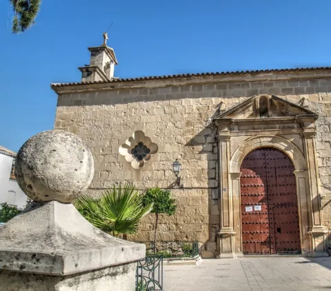
Dating from the 16th century and located in the centre of the municipality, it was built of masonry and reinforced with side buttresses. It consists of a central nave and a chapel. The doorway features a simple, stylised semicircular arch, above which sits a sculpture-less niche closed off with a small triangular pediment. Composed of a single nave decorated with a 17th-century coffered ceiling, now hidden beneath mid-20th-century barrel-vaulted domes. It probably originated with a monastic purpose, although no religious community ever came to settle here.
Telecomunicaciones
Teléfono de contacto
953576603
Ubicación
Código Postal
23659
Latitud
37.83960
Longitud
-4.00094
Dirección
Plaza Constitución, 0
Distrito
Municipio
Ubicación en el mapa
POINT (-4.00094 37.8396)
Tipos de punto de interés
Imágenes carrusel
imagen
Image
Iglesia%20de%20Nuestra%20Se%C3%B1ora%20de%20Gracia_Villadompardo.jpg
Imagen principal
Desactivado
Imágenes cabecera
imagen
Image
iglesia.jpg
Imagen principal
Activado
Loading map
Preparing points of interest and routes...

Iglesia Parroquial de San José

Submitted by brandcode_deweloper on
Id
4897477
Descripción
Breve descripción
Built in the mid-20th century. The interior is accessed through a semicircular arch, above which sits a circular window, topped by a pyramid-shaped bell gable with three bells and a whitewashed façade. Inside, the altarpiece has three sections with three niches, separated by columns and topped with pinnacles. The central niche houses the patron saint.
Telecomunicaciones
Sitio web
www.torreblascopedro.es
Teléfono de contacto
953 62 60 80.
Ubicación
Código Postal
23510
Latitud
37.99745
Longitud
-3.63695
Dirección
Parroquia de San José Paseo del Ayuntamiento, 19
Municipio
Ubicación en el mapa
POINT (-3.63695 37.99745)
Tipos de punto de interés
Imágenes carrusel
imagen
Image
Iglesia%20Parroquial%20de%20San%20Jos%C3%A9.jpg
Imagen principal
Desactivado
imagen
Image
Iglesia%20Parroquial%20de%20San%20Jos%C3%A92.jpg
Imagen principal
Desactivado
Imágenes cabecera
imagen
Image
00001083.jpg
Imagen principal
Activado
Loading map
Preparing points of interest and routes...

Iglesia Parroquial de la Asunción de Nuestra Señora

Submitted by brandcode_deweloper on
Id
4897653
Descripción
Breve descripción
The most notable building in Campillo del Río is the parish church, representative of post-war colonisation architecture. It has a rectangular floor plan and a very spacious interior. Externally, the presbytery is built in exposed brick, while the rest of the building is whitewashed. It was built in 1953 and has recently undergone improvement works.
Telecomunicaciones
Sitio web
www.andalucia.org/es/villacarrillo-turismo-cultural-parroquia-de-nuestra-senora-de-la-asuncion-3
Teléfono de contacto
953636012
Ubicación
Código Postal
23510
Latitud
37.99782
Longitud
-3.63529
Dirección
Torreblascopedro, Jaén
Municipio
Ubicación en el mapa
POINT (-3.63529 37.99782)
Tipos de punto de interés
Imágenes carrusel
imagen
Image
Iglesia%20Parroquial%20de%20la%20Asunci%C3%B3n%20de%20Nuestra%20Se%C3%B1ora.jpeg
Imagen principal
Desactivado
imagen
Image
Iglesia%20Parroquial%20de%20la%20Asunci%C3%B3n%20de%20Nuestra%20Se%C3%B1ora2.jpeg
Imagen principal
Desactivado
Imágenes cabecera
imagen
Image
image_230775.jpg
Imagen principal
Activado
Loading map
Preparing points of interest and routes...

Iglesia Parroquial Virgen de la Estrella

Submitted by brandcode_deweloper on
Id
4553942
Descripción
Descripción larga
On either side, two flared circular windows with polylobed outlines embellish the façade, which ends in a continuous moulding leading to the eaves. At the foot of the church, a prominent vertical section rises, topped by a bell gable that stands taller than the rest of the church, divided into two levels for bells: the first with two semicircular-arched openings, and the second with a single opening crowned by a small pediment bearing a cross at its apex. Below, a small door with large voussoirs, aligned with a raised semicircular-arched window above, gives verticality and marks the symmetry of this section. It stands on a small, charming square, the Plaza de la Constitución, raised above its surroundings and bordered externally by a platform with stone pillars topped with balls and linked by a wrought-iron railing. On one corner outside stands a charming stone fountain bearing the emblem of the Order of Calatrava, crowned with broken and mixtilinear mouldings in the Baroque taste.
Breve descripción
Built in 1723 and rebuilt in 1940, it has a single, box-shaped nave. On the outside, the church displays a clear volumetric geometry that emphasises its rectangular structure and central axis. Its ashlar stonework is carefully finished, and the whole conveys a stern, dignified character. The main doorway is stylised in relation to the elongated façade wall: it opens with a semicircular arch, framed by fillets and pilasters, and is crowned by a broken triangular pediment.
Telecomunicaciones
Sitio web
www.santiagodecalatrava.es/el-municipio/patrimonio-historico.html
Correo electrónico
scalatrava@promojaen.es
Ubicación
Código Postal
23612
Latitud
37.75332
Longitud
-4.17028
Dirección
Plaza Constitucion, s/n
Distrito
Ubicación en el mapa
POINT (-4.17028 37.75332)
Tipos de punto de interés
Imágenes carrusel
imagen
Image
iestrella.jpg
Imagen principal
Desactivado
Imágenes cabecera
imagen
Image
iglesia_%20%281%29.jpg
Imagen principal
Activado
Loading map
Preparing points of interest and routes...

Iglesia Nuestra Señora de la Asunción

Submitted by brandcode_deweloper on
Id
8089251
Descripción
Descripción larga
Its floor plan features three naves, with the central one wider than the rest. The pillars separating the naves have different layouts, and the arches connecting the central nave with the side naves are semicircular, except in the Gothic area of the presbytery, where they are naturally pointed. A barrel vault covers the three bays of the central nave, which is lined by a cornice and defined by false transverse arches resting on buttresses. The presbytery, built in the 14th century, is constructed of ashlar and roughly hewn stone, though only partially, and is covered by a rib vault with tiercerons, diagonals and a ridge rib. The passage from the nave into the presbytery is emphasised by a large pointed chancel arch with roll mouldings and Gothic capitals decorated with lilies. In contrast due to their more recent date are the sacristy, located at the start of the left-hand side, balanced on the opposite side by a chapel. At the foot of the church stands the choir, raised on Solomonic columns, with a wooden balustrade and three basket-handle arches.
Breve descripción
The origins of the parish church of Nuestra Señora de la Asunción are linked to a medieval legend: the apparition of the Virgen de Lorite at a farmstead, expressing her wish to be honoured with a church. Construction of the church began in the 14th century. Its small dimensions reflect its original medieval typology.
Telecomunicaciones
Sitio web
www.lupion.es/el-municipio/patrimonio-historico.html
Ubicación
Código Postal
23528
Latitud
37.99631
Longitud
-3.54652
Dirección
Plaza Ayuntamiento, 2
Municipio
Ubicación en el mapa
POINT (-3.54652 37.99631)
Tipos de punto de interés
Imágenes carrusel
imagen
Image
IGLESIA%20N%C2%AA%20SE%C3%91ORA%20DE%20LA%20ASUNCI%C3%93N%20lupon2.jpg
Imagen principal
Desactivado
Imágenes cabecera
imagen
Image
IGLESIA%20N%C2%AA%20SE%C3%91ORA%20DE%20LA%20ASUNCI%C3%93N%20lupon3.jpg
Imagen principal
Activado
Loading map
Preparing points of interest and routes...

Iglesia Antigua de Nuestra Señora de la Consolación

Submitted by brandcode_deweloper on
Id
7268241
Descripción
Descripción larga
It has a single rectangular nave in the shape of a Latin cross, flanked by side chapels and presided over by an apse-less presbytery. The church is covered by a Mudéjar coffered ceiling with a simple tie-and-collar-beam structure, with five ornamented tie beams decorated with strapwork resting on corbels, which, beneath the choir loft, rest on a transverse beam supported by an Ionic column and a wooden bracket decorated with large acanthus leaves. In this same spirit of austerity, the side doorway was built a century later: a lintelled opening with Tuscan pilasters and no decorative elements. During the Civil War, the wooden altarpiece presiding over the Señor de las Aguas was destroyed, and in 1949 another was installed in its place, presiding over the Señor de la Capilla, a name by which this church is also known. The current bell tower, which replaced a bell gable that collapsed in the early 20th century, was built in 1956–57 on a square, prism-shaped base, with a first section featuring vertically arranged oculi on its shaft, framed by a shared moulding; the second section, smaller and octagonal, has pinnacles at its corners and pairs of semicircular arches for the bells, and is topped by a pyramidal spire.
Breve descripción
Next to the now-vanished Castillo de la Tercia, the old Church of Nuestra Señora María de la Consolación was built at the end of the 15th century, intended to serve as the castle's chapel.
Ubicación
Código Postal
23746
Latitud
37.97076
Longitud
-3.99562
Distrito
Municipio
Ubicación en el mapa
POINT (-3.99562 37.97076)
Tipos de punto de interés
Imágenes carrusel
imagen
Image
Iglesia_Nuestra_Se%C3%B1ora_Mar%C3%ADa_Consolaci%C3%B3n_Lahiguera02%20%281%29.jpg
Imagen principal
Desactivado
Imágenes cabecera
imagen
Image
2496px-Iglesia_Nuestra_Se%C3%B1ora_Mar%C3%ADa_Consolaci%C3%B3n_Lahiguera01%20%281%29.jpg
Imagen principal
Activado
Loading map
Preparing points of interest and routes...

Iglesia Parroquial de la Inmaculada Concepción

Submitted by brandcode_deweloper on
Id
4649876
Descripción
Breve descripción
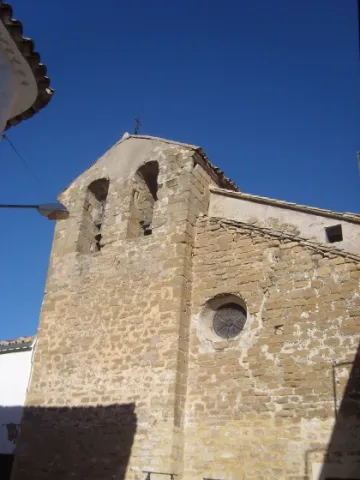
Its origins are medieval, as can be seen inside, where, despite the many alterations and restorations carried out over time, clear traces of late Gothic style survive, such as the helical columns. Baroque traces also remain inside, such as the altarpiece. On the outside, its side façade is Renaissance in style, although it was rebuilt in 1908. The main façade, on the other hand, is Baroque, though also rebuilt. A bell gable with two openings for bells crowns this main façade.
Telecomunicaciones
Sitio web
www.higueradecalatrava.es
Teléfono de contacto
953 52 91 17
Ubicación
Código Postal
23611
Latitud
37.79864
Longitud
-4.15776
Dirección
Plaza España, 4
Distrito
Ubicación en el mapa
POINT (-4.15776 37.79864)
Tipos de punto de interés
Imágenes cabecera
imagen
Image
-22%20164109.jpg
Imagen principal
Activado
Loading map
Preparing points of interest and routes...