Saltar al contenido principal
icon-intereses-senior

Arroyo Salado de Arjona

Submitted by brandcode_deweloper on
Id
8126032
Descripción
Descripción larga
The Salado de Arjona rises in the municipal district of Los Villares and flows through the Campiña region of Jaén in a roughly north–south direction over some 48 km, before flowing into the Guadalquivir river near the town of Marmolejo. The main towns within its basin are Martos and Lopera. It flows into the Guadalquivir within the municipal district of Marmolejo.
Breve descripción
The Salado de Arjona is a river or stream in southern Spain, part of the Guadalquivir river basin, running entirely through the province of Jaén.
Telecomunicaciones
Teléfono de contacto
953 53 00 14
Correo electrónico
lahiguera@promojaen.es
Ubicación
Código Postal
23746
Latitud
38.01654
Longitud
-4.12168
Dirección
Lahigera
Distrito
Municipio
Ubicación en el mapa
POINT (-4.12168 38.01654)
Tipos de punto de interés
Loading map
Preparing points of interest and routes...

Iglesia Antigua de Nuestra Señora de la Consolación

Submitted by brandcode_deweloper on
Id
7268241
Descripción
Descripción larga
It has a single rectangular nave in the shape of a Latin cross, flanked by side chapels and presided over by an apse-less presbytery. The church is covered by a Mudéjar coffered ceiling with a simple tie-and-collar-beam structure, with five ornamented tie beams decorated with strapwork resting on corbels, which, beneath the choir loft, rest on a transverse beam supported by an Ionic column and a wooden bracket decorated with large acanthus leaves. In this same spirit of austerity, the side doorway was built a century later: a lintelled opening with Tuscan pilasters and no decorative elements. During the Civil War, the wooden altarpiece presiding over the Señor de las Aguas was destroyed, and in 1949 another was installed in its place, presiding over the Señor de la Capilla, a name by which this church is also known. The current bell tower, which replaced a bell gable that collapsed in the early 20th century, was built in 1956–57 on a square, prism-shaped base, with a first section featuring vertically arranged oculi on its shaft, framed by a shared moulding; the second section, smaller and octagonal, has pinnacles at its corners and pairs of semicircular arches for the bells, and is topped by a pyramidal spire.
Breve descripción
Next to the now-vanished Castillo de la Tercia, the old Church of Nuestra Señora María de la Consolación was built at the end of the 15th century, intended to serve as the castle's chapel.
Ubicación
Código Postal
23746
Latitud
37.97076
Longitud
-3.99562
Distrito
Municipio
Ubicación en el mapa
POINT (-3.99562 37.97076)
Tipos de punto de interés
Imágenes carrusel
imagen
Image
Iglesia_Nuestra_Se%C3%B1ora_Mar%C3%ADa_Consolaci%C3%B3n_Lahiguera02%20%281%29.jpg
Imagen principal
Desactivado
Imágenes cabecera
imagen
Image
2496px-Iglesia_Nuestra_Se%C3%B1ora_Mar%C3%ADa_Consolaci%C3%B3n_Lahiguera01%20%281%29.jpg
Imagen principal
Activado
Loading map
Preparing points of interest and routes...

Ayuntamiento de Lahiguera

Submitted by brandcode_deweloper on
Id
7274012
Descripción
Descripción larga
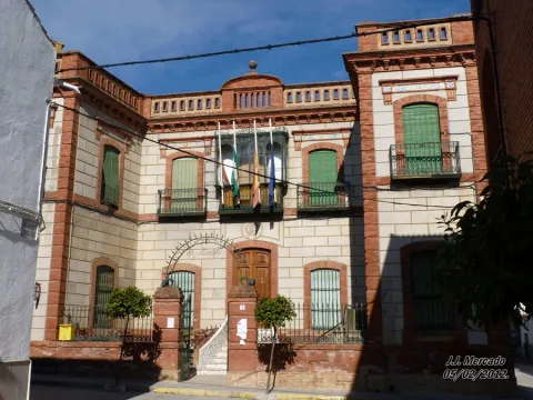
The building is symmetrical, with reinforced corners; its openings are closed with segmental arches, and hierarchy is marked both by the entrance door, emphasised by the access steps, and by the main balcony, from which commemorative events are presided over.
Breve descripción
The most significant civic building is the Town Hall, which, built in 1914 and refurbished from 1973 onwards, retains its original grandeur. Its central section is set back, with its two prismatic side wings projecting outward.
Telecomunicaciones
Teléfono de contacto
953530014
Ubicación
Código Postal
23746
Latitud
37.97062
Longitud
-3.98923
Dirección
C/ Ramon y Cajal, 2
Distrito
Municipio
Ubicación en el mapa
POINT (-3.98923 37.97062)
Tipos de punto de interés
Imágenes carrusel
imagen
Image
unnamed%20%281%29.jpg
Imagen principal
Desactivado
Imágenes cabecera
imagen
Image
P1040405.JPG
Imagen principal
Activado
Loading map
Preparing points of interest and routes...

Casa de los Benavides

Submitted by brandcode_deweloper on
Id
8108113
Descripción
Descripción larga
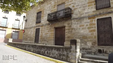
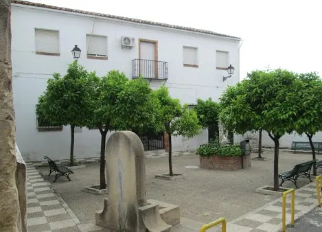
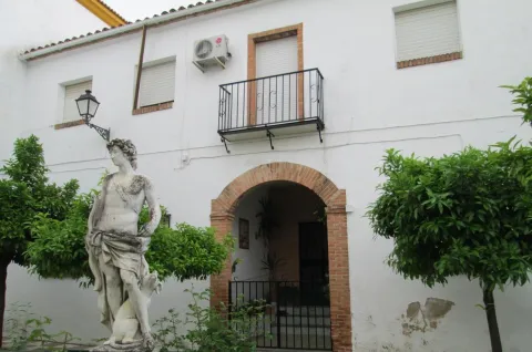
Located in the Plaza del Ayuntamiento. Former mansion of the lords of Ibros. Its structure is still original and stands out above all for its monumental façade and the original stone flooring, which remains fully intact. Ashlar façade with a coat of arms.
Breve descripción
This house belonged to the Benavides family, who were the lords of the town. Its structure is still original and stands out above all for its monumental ashlar façade and the original stone flooring, which remains fully intact. A coat of arms can be seen on the façade.
Telecomunicaciones
Sitio web
www.ayunibros.es
Teléfono de contacto
953 76 60 25
Ubicación
Código Postal
23450
Latitud
38.02256
Longitud
-3.50216
Dirección
Plaza del Ayuntamiento, 12. Ibros
Municipio
Ubicación en el mapa
POINT (-3.50216 38.02256)
Tipos de punto de interés
Imágenes carrusel
imagen
Image
Casa%20de%20los%20Benavides2.jpg
Imagen principal
Desactivado
Imágenes cabecera
imagen
Image
Casa%20de%20los%20Benavides.jpg
Imagen principal
Activado
Loading map
Preparing points of interest and routes...

Muralla Ciclópea de Ibros

Submitted by brandcode_deweloper on
Id
308824
Descripción
Descripción larga
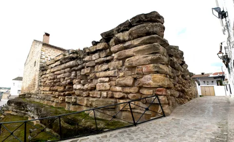
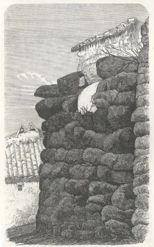
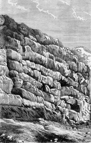
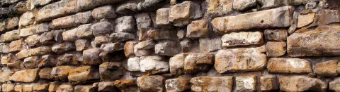
It was Manuel de Góngora, during his journey through the province of Jaén around 1860, who discovered this magnificent wall, stating for the first time that it was of Iberian construction. This Professor of Universal History and Inspector of Antiquities made a spectacular discovery: he was the first to identify the Iberian peoples of the Upper Guadalquivir. More recent studies have identified this type of cyclopean structure with towers and fortified enclosures dating from between the 2nd and 1st centuries BC. In these later stages of Iberian culture, the Romans had already reached the lands of the Guadalquivir, imposing new models of land occupation in which these great defensive structures appear to correspond to strategic sites that delimit and control territories, roads, water sources and even farmland. The cyclopean wall of Ibros, today integrated into the townscape, has survived to the present day as an important architectural element of Iberian culture. Its huge stones, originally joined without mortar, teach us much about those people: their fears, technological advances, struggles and wars, conquests, social transformations… It is located in the northern part of the historic centre, in the district known as "el señorío". Its location makes strategic sense, as it defended the most vulnerable area, closest to the riverbed. It is one of the most celebrated prehistoric monuments in the province of Jaén. A large structure, originally formed by a quadrangular enclosure surrounding the perimeter of the settlement, of which today only a corner measuring 12 to 13 metres long survives. Its enormous ashlar blocks are fitted together without mortar and measure 3.60 metres in length by 1.70 metres in width. We hear nothing more of the town until Christian times, when it was taken in 1157. It later fell once again into Arab hands, until it was definitively conquered by Ferdinand III the Saint. During the reign of Philip IV, the town's defence consisted of a small castle and a wall in which the Ibero-Roman cyclopean wall was reused. The old castle of Ibros must have gradually fallen into disuse, like the rest of the region's fortresses, since after the fall of Granada in 1492 there was no immediate external threat, and advances in artillery made such fortifications unnecessary.
Breve descripción
The Cyclopes were mythological beings with only one eye, members of a race of giants — strong, hot-tempered and prone to sudden emotions. Mythology tells us they were great builders and craftsmen, and this is why, during the Middle Ages, walls made of large worked blocks — like this one in Ibros — began to be discovered and came to be called "cyclopean structures", leading to the conclusion that only the Cyclopes possessed the skill and strength needed to build them.

Telecomunicaciones
Teléfono
Visita exterior, no precisa reservar para su visita.

*Consejos para la visita

Se aconseja comenzar la visita desde la Plaza del Ayuntamiento, dirigiéndonos hacia la calle Gradas llegaremos a la calle del Pilar donde se localiza la muralla.
Sitio web
www.ayunibros.es
Ubicación
Código Postal
23450
Latitud
38.02357
Longitud
-3.50342
Dirección
C/ Pilar, 1
Municipio
Ubicación en el mapa
POINT (-3.50342 38.02357)
Tipos de punto de interés
Imágenes carrusel
imagen
Image
murralla.png
Imagen principal
Desactivado
imagen
Image
muralla_ciclopeda_5.jpg
Imagen principal
Desactivado
imagen
Image
muralla_ciclopeda_4.jpg
Imagen principal
Desactivado
Imágenes cabecera
imagen
Image
Ibros_cab%20%281%29.jpg
Imagen principal
Activado
Horario
Abierto 24 horas
Microsite al que pertenece
Loading map
Preparing points of interest and routes...

Fuente Palacios

Submitted by brandcode_deweloper on
Id
4650607
Descripción
Descripción larga
Since the mid-20th century, the Romería de San Isidro has been held at Fuente Palacios on 15 May, in which the patron saint of farmers is carried in procession from Higuera de Calatrava to his hermitage, where locals gather for lunch and spend a festive day featuring float and horse competitions.
Breve descripción
The Fuente Palacios Natural Site is located very close to Higuera de Calatrava, barely a kilometre south of the town centre, and is reached via the J-2110 road towards Santiago de Calatrava. This natural spot, also known as San Isidro after the hermitage of the same name found here, offers beautiful views, thanks in particular to a large grove of trees. It has a good range of facilities for recreation and leisure, a picnic area without tables, a stage, a play area and a hostel currently under construction.
Telecomunicaciones
Sitio web
www.higueradecalatrava.es
Teléfono de contacto
953 529107
Ubicación
Código Postal
23611
Latitud
37.785080521129764
Longitud
-4.152102550592038
Dirección
Cortijo de Fuente Palacios
Distrito
Ubicación en el mapa
POINT (-4.152102550592 37.78508052113)
Tipos de punto de interés
Imágenes carrusel
imagen
Image
Fuente%20Palacios%20%281%29.jpg
Imagen principal
Desactivado
Imágenes cabecera
imagen
Image
natural8.jpg
Imagen principal
Activado
Loading map
Preparing points of interest and routes...

Casa del Párroco

Submitted by brandcode_deweloper on
Id
4650308
Descripción
Breve descripción
Attached to the church on the side opposite the square, the Priest's House is representative of 17th-century popular Baroque style. It shows a distinctive structure of recesses and projections, creating optical and perspective effects through its broken, angular forms. Notable is the asymmetrical arrangement and variety of its openings, ranging from the lintelled door and the rectangular windows and balcony to the small segmental-arched windows of the attic storey, along with the circular window in between.
Telecomunicaciones
Sitio web
www.higueradecalatrava.es/el-municipio/patrimonio-historico.html
Teléfono de contacto
953 529107
Ubicación
Código Postal
23611
Latitud
37.79849
Longitud
-4.15767
Dirección
C/ Huerta, 1
Distrito
Ubicación en el mapa
POINT (-4.15767 37.79849)
Imágenes carrusel
imagen
Image
casa%20del%20parroco%202.jpg
Imagen principal
Desactivado
Imágenes cabecera
imagen
Image
1.jpg
Imagen principal
Activado
Loading map
Preparing points of interest and routes...

Iglesia Parroquial de la Inmaculada Concepción

Submitted by brandcode_deweloper on
Id
4649876
Descripción
Breve descripción
Its origins are medieval, as can be seen inside, where, despite the many alterations and restorations carried out over time, clear traces of late Gothic style survive, such as the helical columns. Baroque traces also remain inside, such as the altarpiece. On the outside, its side façade is Renaissance in style, although it was rebuilt in 1908. The main façade, on the other hand, is Baroque, though also rebuilt. A bell gable with two openings for bells crowns this main façade.
Telecomunicaciones
Sitio web
www.higueradecalatrava.es
Teléfono de contacto
953 52 91 17
Ubicación
Código Postal
23611
Latitud
37.79864
Longitud
-4.15776
Dirección
Plaza España, 4
Distrito
Ubicación en el mapa
POINT (-4.15776 37.79864)
Tipos de punto de interés
Imágenes cabecera
imagen
Image
-22%20164109.jpg
Imagen principal
Activado
Loading map
Preparing points of interest and routes...

Ayuntamiento de Fuerte del Rey

Submitted by brandcode_deweloper on
Id
4518252
Descripción
Descripción larga
Opposite the church entrance, on higher ground, in the most representative space of the municipality, the Plaza de la Constitución, stands the Town Hall — a simple, functional building with an elongated layout, recently refurbished, dominated by exposed brick across its two sections, with an irregular, asymmetrical arrangement of openings, a stone coat of arms of the town featuring the imperial double-headed eagle as its heraldic emblem, and topped by a small pediment with a clock and bell, on whose iron structure the date 1933 appears.
Telecomunicaciones
Teléfono de contacto
953 37 60 11
Correo electrónico
ayuntamiento@fuertedelrey.es
Ubicación
Código Postal
23180
Latitud
37.87408
Longitud
-3.88461
Dirección
Plaza de la Constitución 1
Distrito
Municipio
Ubicación en el mapa
POINT (-3.88461 37.87408)
Imágenes carrusel
imagen
Image
fuerte%20del%20rey.jpg
Imagen principal
Desactivado
Imágenes cabecera
imagen
Image
fuerte%20del%20rey%202.jpg
Imagen principal
Activado
Loading map
Preparing points of interest and routes...

Parque Municipal de Fuerte del Rey

Submitted by brandcode_deweloper on
Id
8113746
Descripción
Descripción larga
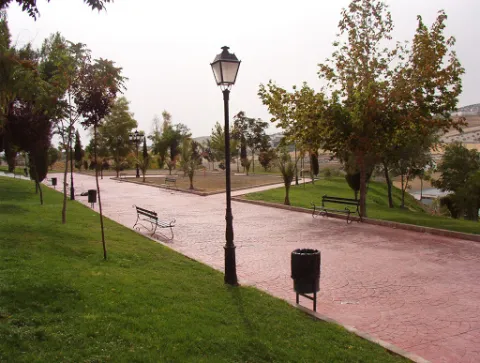
The great appeal of this park lies in its views and the large number of benches for resting, along with its function as an eco-park, allowing visitors to exercise on its outdoor gym equipment, although access to these is over uneven ground. The park has a children's play area that is not accessible, as it has a step of around 12 cm.
Breve descripción
A park located in the highest part of Fuerte del Rey, from where almost the entire town can be seen. At the main entrance there is a slight side incline that makes access more difficult.
Telecomunicaciones
Teléfono de contacto
953 37 60 11 / 953 37 61 17
Correo electrónico
ayuntamiento@fuertedelrey.es
Ubicación
Código Postal
23180
Latitud
37.87573
Longitud
-3.88143
Dirección
C/ Antonio Machado, nº 20
Distrito
Municipio
Ubicación en el mapa
POINT (-3.88143 37.87573)
Tipos de punto de interés
Imágenes carrusel
imagen
Image
Parque%20Municipal%20Fuerte%20del%20Rey2.jpg
Imagen principal
Desactivado
Imágenes cabecera
imagen
Image
Parque%20Municipal%20Fuerte%20del%20Rey.jpg
Imagen principal
Activado
Loading map
Preparing points of interest and routes...