Saltar al contenido principal
icon-intereses-amigos

Castle of Villardompardo

Submitted by brandcode_deweloper on
Id
PUN-0002
Perfil de redes sociales
Descripción
Descripción larga
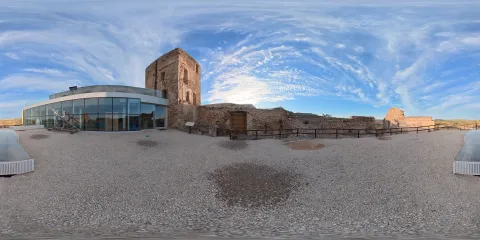
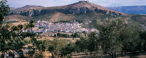
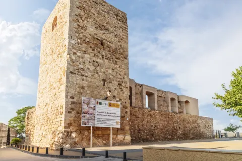
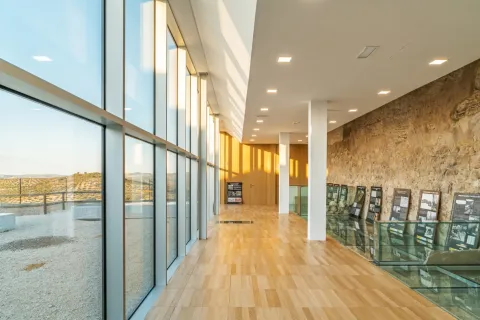
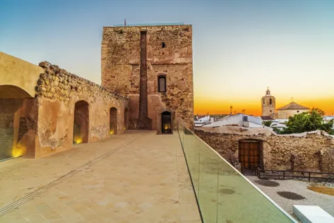
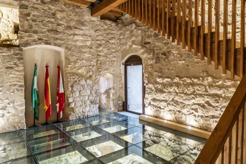
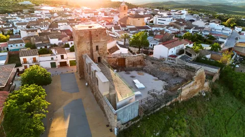
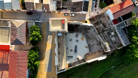
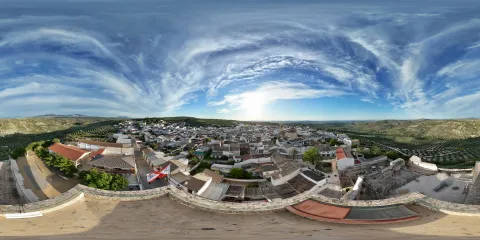
En la zona en que se asienta el castillo se han documentado estructuras de hábitat y almacenaje (una estructura hidráulica, silos y fondos de cabañas) pertenecientes a un poblado de la Edad del Cobre. Del asentamiento romano se puede distinguir un doble recinto amurallado, protegido por un foso en el lado norte, que reforzaba su defensa. Probablemente se articularía en torno a una torre situada al suroeste, a la que corresponderían los mampuestos de gran tamaño que cimientan el torreón medieval. En su interior se levantarían edificios de los que han quedado pocos vestigios, con estructuras de almacenaje de producción agrícola y de agua. La fortaleza medieval, erigida entre los siglos XIII y XIV, aprovechando los restos de época romana, consistía en un recinto amurallado en forma de trapecio irregular, con cuatro torres, de las que en la actualidad se conservan tres: una gran torre rectangular que ocupa el ángulo suroeste; una pequeña y circular al noroeste de la que solo se conserva la base; y otra rectangular, maciza, al noreste, que defendía la puerta del castillo. En la esquina sureste existió una cuarta torre, desaparecida en el siglo XIX. El conjunto está construido en mampostería, excepto el muro sur, con alzado de tapial. El torreón suroeste, o torre del Homenaje, se divide en tres plantas más una baja, ocupada por un aljibe. En algunos puntos de la torre del homenaje se pueden distinguir aún restos de la decoración original que cubriría los muros de la fortificación, un dibujo de hojas o gotas mediante técnicas de esgrafiado, decoración que cubriría también las murallas y la torre maciza. La puerta original de la torre estaba fuertemente defendida, de doble hoja, tendría una buhedera para arrojar líquidos o piedras sobre los atacantes y un rastrillo. Este acceso se cegó al construirse un aljibe en el interior de la torre, que ocupa casi toda la planta baja de la torre. La cubierta abovedada del aljibe ha desaparecido, pero aún se conservan dos elementos relacionados con el mismo, una estructura de decantación y un pozo para la extracción del agua. Las intervenciones arqueológicas que sacaron a la luz este depósito de agua, recuperaron también la escalera original embutida en el muro norte de la torre. Ambos pueden contemplarse en la visita, pudiéndose caminar sobre el aljibe. La subida al torreón culmina en la terraza, que ofrece un amplio control visual del territorio, divisándose emplazamientos como El Berrueco, Andújar, Arjona o Martos, lo que explica la elección de este emplazamiento para la construcción de la fortificación. Su ubicación sobre una pronunciada ladera actuaba como defensa natural, pero los lados norte y oeste, más accesibles, estaban protegidos por un amplio foso de unos 7 m de anchura y una profundidad máxima de 2,10 m, oculto hasta su recuperación en intervenciones arqueológicas recientes. El foso se extendía entre dos torres reforzadas mediante escarpas aún visibles. A partir del siglo XVI se abre una nueva puerta en la muralla oeste, con una portada renacentista que aún se conserva, realizada en piedra de cantería. Está formada por dos cuerpos, el inferior con arco de medio punto sobre pilastras y el segundo con un gran cartelón rectangular en el centro, que alberga las armas de don D. Fernando de Torres y su primera esposa Dª. Francisca de Carvajal y Osorio. La mayor transformación fue la construcción de cuerpos adosados a las murallas, formando un gran espacio residencial. La torre del Homenaje y la muralla sur conservan vanos que los comunicarían entre sí. Actualmente se reconocen las plantas bajas de estas construcciones, aunque habrían alcanzado entre dos y tres pisos de altura. Estos cuerpos albergaron el “espacio privilegiado” del palacio, es decir, las habitaciones del conde y la condesa, la capilla, la cripta, el zaguán y un corredor-galería o atrio, en el cuerpo oeste, mientras que en el edificio sur se dedicaba la planta baja al almacenaje, reservando la primera para el principal espacio representativo del palacio, un gran salón con una chimenea tallada en la fachada de la torre. Las estructuras situadas al norte y al este estarían dedicadas principalmente al servicio, incluyendo las caballerizas, cocinas y un sótano. Las intervenciones arqueológicas confirmaron la existencia de un asentamiento prehistórico, de la Edad del Cobre, en la loma en que hoy se encuentra el castillo. La presencia de dientes de hoz, molinos y silos de almacenaje apuntan hacia una economía agrícola basada en el cultivo de cereales. Se han localizado también una estructura hidráulica, estructuras de hábitat subterráneas y de hoyos de poste. No parece existir una continuidad en la ocupación del espacio, por lo que debió producirse un abandono temporal del asentamiento. Desde principios del siglo I a. n. e. hasta el II d. n. e. se produjo en la campiña un incremento de asentamientos agrícolas dedicados al cultivo del cereal. En esos momentos, se produce una reocupación de este espacio, un asentamiento fortificado, cuyo mayor apogeo se situaría entre el primer cuarto del siglo I y el siglo II d.n.e., a partir del cual se abandona nuevamente. El termino villar en la Baja Edad Media identificaba un lugar con restos de un asentamiento antiguo abandonado. Tras la conquista del territorio, los castellanos se establecen en el lugar cuando aún serían visibles las estructuras romanas, optando por reaprovechar algunas, así como material de construcción, para erigir el castillo. La aldea de El Villar de Don Pardo, se menciona ya en las fuentes en 1251, pero el castillo no se construirá hasta finales del siglo XIII o principios del XIV, aludiéndose por primera vez a la fortificación en 1416, como lugar perteneciente aún al Concejo de Jaén. Posteriormente Fernando Ruiz de Torres conseguiría la cesión de la aldea. En la segunda mitad del siglo XV, siendo señora del lugar Teresa de Torres, casada con el Condestable de Castilla Miguel Lucas de Iranzo, Villardompardo se convierte en una de las líneas de defensa de los partidarios de Enrique IV frente a la nobleza levantisca, acaudillada en la zona por la Orden de Calatrava. El fallecimiento sin herederos de su hijo, hizo pasar el señorío a una rama lateral de los Torres, que entroncó con la familia de Pedro I de Portugal. Felipe II lo erigió en cabeza de condado al nombrar a Don Fernando de Torres y Portugal conde de Villardompardo en 1576. Entre finales del siglo XVI y principios del siglo XVII se realizará la conversión del castillo en palacio, como vivienda habitual de los condes. Sus sucesores, sin embargo, instalaron su residencia en la Corte, en Madrid, lo que inició un proceso de ruina, por falta de mantenimiento. La abolición de los mayorazgos en el reinado de Fernando VII obligó a repartir la herencia, desvinculándose el castillo de Villardompardo de la rama nobiliaria principal. A finales del siglo XIX o principios del XX, se derribaron los edificios construidos en el siglo XVI, dejando solo los muros perimetrales, allanando la superficie y tallando gradas en la muralla norte para convertir temporalmente el recinto en una plaza de toros. El castillo ha sido objeto de diversos trabajos de consolidación de urgencia, excavaciones arqueológicas y restauración entre 2012 y 2023.
Breve descripción
The castle of Villardompardo, built between the 13th and 14th centuries, is a walled enclosure built mainly in masonry. It was pulled by four towers, among which the great tower of tribute stands out, and protected on its northwest side by a pit. From the 16th century a profound transformation of the fortress will begin, until its conversion into a large rural building, the residence-palace of the Condes de Villardompardo, of which the monumental cover or the aljibe that occupies the ground floor of the torreon stands out. The space in which it is located has housed a town of the Copper Age and a fortified Roman settlement dated between the beginning of the 1st and the 2nd century d.o.d., of which numerous structures are preserved. After the Spanish conquest of this territory, the Spanish raised a fortress that played an important role in the nobility struggles of the 15th century, becoming one of the lines of defense of the supporters of Henry IV. Philip II raised him to the head of the county by naming Don Fernando de Torres and Portugal Count of Villardompardo in 1576.
Ubicación
Código Postal
23659
Distrito
Municipio
Tipos de punto de interés
Imágenes carrusel
imagen
Image
Castillo de Villardompardo
Imagen principal
Desactivado
imagen
Image
Castillo de Villardompardo
Imagen principal
Desactivado
imagen
Image
Castillo de Villardompardo
Imagen principal
Desactivado
imagen
Image
Castillo de Villardompardo
Imagen principal
Desactivado
Imágenes cabecera
imagen
Image
CyB_Villadompardo_01
Imagen principal
Desactivado
imagen
Image
CyB_Villadompardo_02
Imagen principal
Desactivado
Microsite al que pertenece
Experiencia 360
Image
CyB_Villadompardo_03_360
Image
CyB_Villadompardo
Marcas de calidad

Arroyo del Gallo Country House

Submitted by brandcode_deweloper on
Id
10635457
Redes sociales
Facebook
https://www.facebook.com/arroyodelgallo
Descripción
Breve descripción

During your stay in Viña Arroyo del Gallo you can enjoy nature and make many hiking and mountain bike routes, being located next to the Natural Park of the Sierra de Andújar.

More known as the La Alcaparrosa area, it is a place surrounded by pineapple forests and Mediterranean bushes, where the tranquility and harmony of nature reigns. So here it will be very easy for you to disconnect from everything that has to do with the city.

In addition, in 15 minutes we can reach Andújar and within an hour's drive you can visit the cities of Jaén, Córdoba, Baeza and Ubeda. We will receive you and report all the services of the house.

Información de contacto
Teléfono
635 401 749
Teléfono de contacto
639 388 918
Correo electrónico
vinaarroyodelgallo@gmail.com
Ubicación
Código Postal
23740
Latitud
38.125496
Longitud
-4.032780
Dirección
Ctra. de la Alcaparrosa, km. 8
Distrito
Municipio
Ubicación en el mapa
POINT (-4.03278 38.125496)
Tipo de alojamiento
Imágenes
imagen
Image
arroyo%20del%20gallo.jpg
Imagen principal
Activado
imagen
Image
arroyo%20del%20gallo%202.jpg
Imagen principal
Desactivado
imagen
Image
arroyo%20del%20gallo%203.jpg
Imagen principal
Desactivado
imagen
Image
arroyo%20del%20gallo%204.jpg
Imagen principal
Desactivado
Loading map
Preparing points of interest and routes...
El Hotel

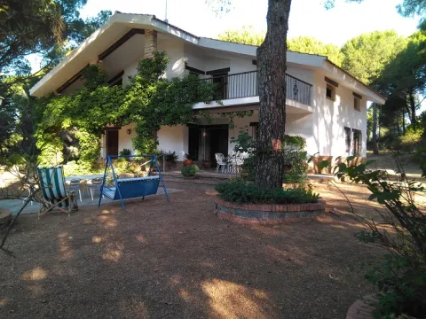
Casa Rural Viña Arroyo del Gallo is a beautiful rural house located next to the Natural Park of the Sierra de Andújar, in the town of Andújar (Jaén).

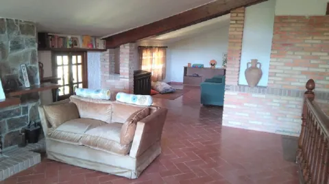
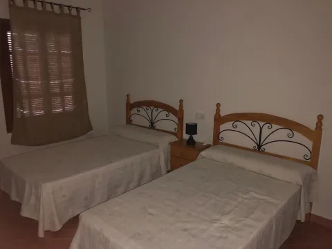
It is located on a plot of 5,000 m ² and consists of two floors with six bedrooms - one with bathroom included - three bathrooms, a living room of 50 m ² on the ground floor and one on the upper floor, large kitchen open to the dining room, salita on the upper floor and pantry.

There are three bedrooms with a bed of 135 and three with two beds of 105. In the bedrooms there is heating by radiators and in each living room there is a fireplace. The house has WIFI and TV.

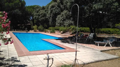
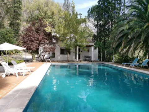
On the outside we can find a landscaped strip and then a large, sunny pool and, next to it, an oak that provides a fantastic shade area.

Arroyo Colmenar Country Cottage

Submitted by brandcode_deweloper on
Id
4396022
Descripción
Breve descripción

Located in the town of Villanueva del Archbishop, we find theCasa Arroyo Colmenar,which has6 places. 3 double bedrooms, one has a double bed, while the others have 2 single beds each.

Información de contacto
Teléfono
606 272 731
Ubicación
Código Postal
23330
Latitud
38.186070
Longitud
-2.892990
Dirección
Ctra. del Tranco. Paraje Rompecalzas
Ubicación en el mapa
POINT (-2.89299 38.18607)
Tipo de alojamiento
Imágenes
imagen
Image
ARROYO%20COLMENAR.jpg
Imagen principal
Activado
imagen
Image
casarural_39.jpg
Imagen principal
Desactivado
Loading map
Preparing points of interest and routes...
El Hotel

This family house has fully equipped interiors. A spacious living room in which living and dining room share a stay. The kitchen is equipped with everything you need (ceramic, oven, dishwasher, washing machine...).

Surrounded by a pure nature: the gentle murmur of the waters of the river, or the sweet pear of the birds on the trees of the farm itself. On the outside you will be able to spend great moments, for example, in thepool.

Take this opportunity to know places of interest like Ubeda or Baeza.

Frailes RV Overnight Parking Area

Submitted by brandcode_deweloper on
Id
11764809
Descripción
Breve descripción

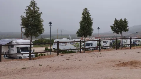
Caravan area with water change service. Located in the local fair. Very close to the city centre and the shopping area.

The caravan area is within the parking lot of the fairground. Free area, maximum stay, 48 hours.
No tables, chairs, etc... All services are in the city centre, about 600 m.

To highlight the Church of Saint Lucia (16th century) and the House of Mudarra. In the area, the fortress and the historic town of Alcalá la Real (20 km) deserve a visit.

Información de contacto
Teléfono
953 593 002
Sitio web
turismofrailes.com
Ubicación
Código Postal
23690
Latitud
37.488330
Longitud
-3.830830
Dirección
C/ Mecedero, s/n
Distrito
Municipio
Ubicación en el mapa
POINT (-3.83083 37.48833)
Tipo de alojamiento
Imágenes
imagen
Image
Frailes.jpg
Imagen principal
Activado
Horario
24 h
Loading map
Preparing points of interest and routes...
El Hotel

Includes the following services

  • Empty of grey water

  • emptying of black water

  • Water filling

  • Baths

Slow travel in Fries. The charm of Fries can already be seen in the distance, although it is even more felt when you discover its picturesque streets that go on to make and deal with its orography. Here we find acut that divides the villageand that it is unique to that of other nearby peoples.

Quesada RV Overnight Parking Area

Submitted by brandcode_deweloper on
Id
11766840
Descripción
Breve descripción

Quesada, from where many routes to the natural park start, you can also enjoy the medieval historical centre, the Rafael Zabaleta Museum, the Center for the Interpretation of the Archaeological Heritage of Quesada, the Miguel Hernández Museum and the Romana Villa of Bruñel, about 7 km away.

Información de contacto
Teléfono
953 733 025
Sitio web
https://ayuntamientoquesada.es
Ubicación
Código Postal
23480
Latitud
37.846940
Longitud
-3.070830
Dirección
Av. de Úbeda, 32
Municipio
Ubicación en el mapa
POINT (-3.07083 37.84694)
Tipo de alojamiento
Imágenes
imagen
Image
quesada%20ruta%20%20de%20los%20nazaries%205.jpg
Imagen principal
Activado
Qué ofrece

Rates. Parking and overnight: Free. Water change: 4 €. Electricity: 5 €/ day. It is paid in the tourist office a few meters away. Authorized stay, 72 hours. No tables, chairs, awnings, etc... More info: + 34 953 714 011.

Loading map
Preparing points of interest and routes...
El Hotel

Rates. Parking and overnight: Free. Water change: 4 €. Electricity: 5 €/ day. It is paid in the tourist office a few meters away. Authorized stay, 72 hours. No tables, chairs, awnings, etc... More info: + 34 953 714 011.

Capacity of 8 caravans. services:

  • Empty of grey water

  • emptying of black water

  • Buses of light

  • Water filling

Pozo Alcón RV Overnight Parking Area

Submitted by brandcode_deweloper on
Id
11766754
Descripción
Breve descripción

Well Alcónis foundto the south of the Natural Park of the Sierras de Cazorla, Segura and Las Villas,between two landscapes that combine the verdor of the mountains with the dryness of the lowlands that border Granada.

Theagriculture is the main activity, highlighting theolive cultivation,herbaceous plantsandalmonds. ThelivestockIt is also an important activity, dominated by sheep (Segureño lamb) and poultry.

Tourismis consolidating asa future activityin the so-called environment"Sierra del Pozo,"where there are numerous sites of great environmental value and exceptional landscapes. Near the village is the beautiful area of theBread reservoir.

All this allows the enjoyment of numerous and varied activities ranging from extreme sports, hiking through sports fishing, observation of fauna and flora and astronomical observation.

In July the Water Festival is very popular with recreational, cultural, sports and gastronomic activities.

Información de contacto
Teléfono
953 738 041
Sitio web
www.pozoalcon.es
Ubicación
Código Postal
23485
Latitud
37.707500
Longitud
-2.939720
Dirección
C/ Atalayuela, 78
Municipio
Ubicación en el mapa
POINT (-2.93972 37.7075)
Tipo de alojamiento
Imágenes
imagen
Image
535_img.png
Imagen principal
Activado
Qué ofrece

If for anything this municipality is known is for its surroundings, so the most interesting thing to see in Pozo Alcón is in the middle of nature. A few minutes from the village is the Tiscar shrine and the Water cave, the last Arab bridge of the area that has a castle on the rock and the port between the mountains. There are also different viewpoints spread through the well saw from which the indigenous birds can be seen as the guazalamanco lookout, Peña Quesada or the Alcantilla ravine.

Loading map
Preparing points of interest and routes...
El Hotel

Maximum authorized stay, five days. Services included:

  • Empty of grey water

  • Buses of light

  • Water filling

La Guardia de Jaén RV Overnight Parking Area

Submitted by brandcode_deweloper on
Id
11766651
Descripción
Breve descripción

The Jaén Guard is located on the hill of San Marcos, in the foothills of the natural park of Sierra Magina. Dominated by the ensemble that form the castle and church of Santa Maria, in ruins, the town has numerous steep streets.

Información de contacto
Teléfono
953 327 100
Sitio web
http://laguardiadejaen.com
Ubicación
Código Postal
23170
Latitud
37.742568
Longitud
-3.693708
Dirección
Recinto Ferial. JV-2226, La Guardia
Distrito
Ubicación en el mapa
POINT (-3.693708 37.742568)
Tipo de alojamiento
Imágenes
imagen
Image
La%20Guardia%20de%20Ja%C3%A9n.jpg
Imagen principal
Activado
Horario
24 h
Qué ofrece

Small municipality located in the west of the Sierra Mágina region, a few kilometres from the capital. The urban core, located at the eastern end of the Cerro de San Cristóbal, looking at the Guadalbullion River, conserves the tipism of its white houses and its steep and narrow streets.

Among the natural enclaves of interest of La Guardia are the Cerro de San Cristóbal, whose summit is repopulated with pine trees, and the Vega of the Guadalbullón river itself, which continues to preserve an abundant riverside vegetation.

La Guardia offers many possibilities for walking, horse or bicycle excursions, such as the Cañada del Santo or the banks of the Guadalbullion River. Of archaeological interest are the settlements of Guadaola (period of emiral), the Roman villa of the Yuca, or the different Ibero-Roman necropolis of Las Eas de San Sebastián and Barranquillo.

The castle, of Arab origin, which was remodeled as a palacio-citadel by the Messias in the 14th and 15th centuries, is the main architectural jewel of the town, along with the parish Church of the Assumption, a work of the 16th century that was originally convent of the Dominicans.

Loading map
Preparing points of interest and routes...
El Hotel

The services available to the area are:

  • Empty of grey water
  • emptying of black water

  • Water filling

Génave RV Overnight Parking Area

Submitted by brandcode_deweloper on
Id
11765759
Descripción
Breve descripción

The Génave (Jaén) motorhome area is 4 km from the roadN-322/ A-32, in a fenced enclosure withzahorraGood.level, large squaresReservedandlightingnight, no shadows, located in an easy-to-reach area with beautifulview,Easy.to stay in a rural environment.

Génave is a town of700inhabitants, which has several bars, supermarkets, bakery, pharmacy, stanco, and health center, available to400 mof the car area.

Información de contacto
Teléfono
953 493 053
Sitio web
https://caravanasgenave.com/
Correo electrónico
ayuntamiento@genave.es
Ubicación
Código Postal
23392
Latitud
38.319154
Longitud
-2.787126
Dirección
Camino de Génave a la Puerta
Distrito
Municipio
Ubicación en el mapa
POINT (-2.787126 38.319154)
Tipo de alojamiento
Imágenes
imagen
Image
inicio_01-jpg
Imagen principal
Activado
imagen
Image
post_1-jpg
Imagen principal
Desactivado
Horario
24 h
Qué ofrece

Génave is a town of700inhabitants, which has several bars, supermarkets, bakery, pharmacy, stanco, and health center, available to400 mof the car area.

Loading map
Preparing points of interest and routes...
El Hotel

The night area of Génave includes the following services.

  • Capacity 10 places maximum stay 72 h
  • Open all year 24 h for free
  • Pets allowed
  • Filling and emptying of grey and black waters
  • Drinking water

Úbeda RV Parking Area

Submitted by brandcode_deweloper on
Id
11767010
Redes sociales
Facebook
https://www.facebook.com/ubeda.turismo
Descripción
Breve descripción

The city (World Heritage) has 48 notable monuments and over a hundred buildings of interest (Renaissance, Arab, Baroque and Gothic). Very important your Holy Week. A must visit to the Museum of the pottery and the Centre for the interpretation of the olive and oil.

Información de contacto
Teléfono
953 779 204
Sitio web
www.turismodeubeda.com
Correo electrónico
promocion@ubeda.es
Ubicación
Código Postal
23400
Latitud
38.006390
Longitud
-3.379440
Dirección
Travesía del Comendador Messía, s/n
Municipio
Ubicación en el mapa
POINT (-3.37944 38.00639)
Tipo de alojamiento
Imágenes
imagen
Image
visita-ubeda-baeza-individuales.jpg
Imagen principal
Activado
Horario
24 h
Qué ofrece

Ubeda has a beautiful monumental and cultural heritage that makes it a fundamental destination for those interested in the Renaissance architecture.

From its heritage we will highlight the excellent degree of conservation of many of its buildings, which still keep details of the time as can be the doors of claveted wood, the iron aldabas, the lanterns and the bars.

Loading map
Preparing points of interest and routes...
El Hotel

Free parking. Maximum stay, 48 hours. It is not allowed to remove chairs, tables, or other camping elements. All services and the historic centre are about 800 m away.

Number of places: 10 places.

Maximum permanence:Two nights.

Services included:

  • Empty of grey water

  • emptying of black water

  • Water filling

Vitores Apartments

Submitted by brandcode_deweloper on
Id
10614971
Redes sociales
Facebook
https://www.facebook.com/Vitores-Apartamentos-Turisticos-%C3%9Abeda-625390631190863/
Instagram
https://www.instagram.com/vitoresubeda/
Descripción
Breve descripción

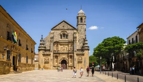
The Vítores Apartments are located in the heart of the historic city heritage of the humanity of Ubeda. Just a few steps away from the main tourist points of interest of the Renaissance city, such as La Sacra Capilla del Salvador, Plaza Vázquez de Molina or the emblematic Church of San Pablo.

Información de contacto
Teléfono
633 428 961
Sitio web
https://www.vitoresapartamentos.com/
Correo electrónico
vitoresubeda@gmail.com
Ubicación
Código Postal
23400
Latitud
38.008466
Longitud
-3.367803
Dirección
C/ Juan Ruíz González, 22
Municipio
Ubicación en el mapa
POINT (-3.367803 38.008466)
Tipo de alojamiento
Imágenes
imagen
Image
vitores%206.jpg
Imagen principal
Activado
imagen
Image
vitores%207.jpg
Imagen principal
Desactivado
imagen
Image
vitores%208.jpg
Imagen principal
Desactivado
Idiomas
Las habitaciones

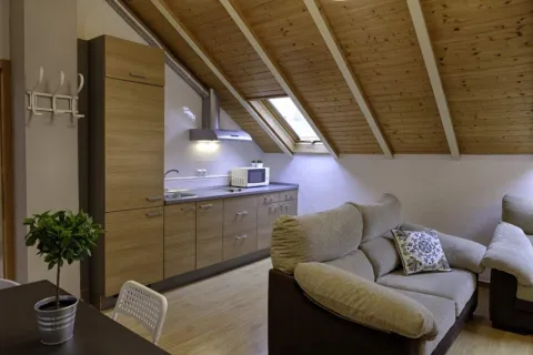
The accommodation has air conditioning, fully equipped kitchen with dining area, flat-screen TV and private bathroom with shower, hairdryer and free toiletries. There is also a microwave, fridge and stove, as well as coffee maker and kettle.

Loading map
Preparing points of interest and routes...
El Hotel

Our apartments are in a privileged area to visit the center of the Ubeda, without giving up a quiet rest. We are in the center of an oasis of Renaissance palaces, church stories with its time bells, between a sea of olive trees with infinite viewpoints,... Ubeda in love and her stay in our apartments will make your visit a unique moment full of sensations.