Saltar al contenido principal

Fountain of the Seven Spouts. Albanchez de Mágina

Submitted by brandcode_deweloper on
Id
1735433
Descripción larga

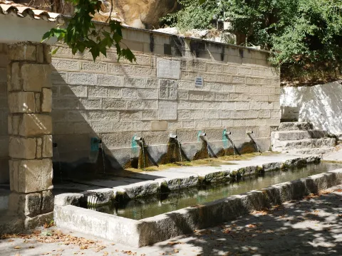
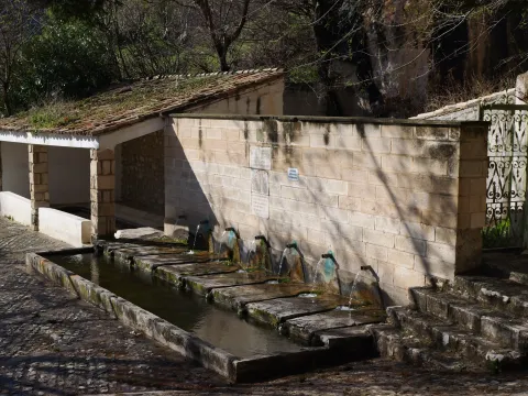
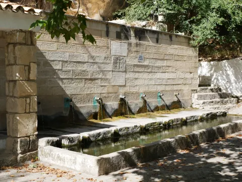
The Fuente de los Siete Caños is a water spring located about 500 metres south of the town of Albanchez de Mágina. This is a clear example of rural architecture, one that combined aesthetics with functionality to pleasing effect. In this case, little explanation is needed, as it is plain to see how the water was put to use for the trough, the washing place, and the irrigation of nearby market gardens and olive groves.

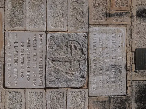
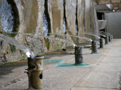
The fountain's construction features a finely finished stone ashlar front. It has seven water spouts, in bronze pipes, which give it a pleasing appearance. It carries a fairly abundant flow, which has never dried up, although in times of drought it tends to reduce somewhat.

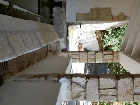
The water flow collects in a trough of modest depth, which until recently was used to quench the thirst of the "beasts" that worked the land. Each spout carries a variable flow, with the last one carrying the greatest. Attached to it is a public washing place, featuring two rows for washing clothes and an iron fitting. The water from the washing place flows from the trough through a small stone channel, fitted with a grille to protect anyone passing over it.
The rest area also has street furniture for sitting and enjoying impressive views of the Albanchez river, El Torcal and Bedmar.

This spot also lies along the Route to the Caldera del Tío Lobo, so if you enjoy hiking, don't hesitate to walk it. And once you've completed it, stop, rest and enjoy the surroundings.


Breve descripción

Fountain with seven water spouts, which give it its name. It has a stone-fronted trough and a public washing place, an example of traditional rural architecture linked to the use of water for drinking and for irrigating market gardens, dating back to the 16th century.

Latitud
37.788118
Longitud
-3.466169
Distrito
Ubicación en el mapa
POINT (-3.466169 37.788118)
imagen
Image
p1080490-jpg
Imagen principal
Activado
imagen
Image
p1080488-jpg
Imagen principal
Desactivado
imagen
Image
p1080494-jpg
Imagen principal
Desactivado
imagen
Image
p1022493-jpg
Imagen principal
Desactivado
imagen
Image
dji_20250522110724_0010_d-jpg
Imagen principal
Desactivado
imagen
Image
p1023710-jpg
Imagen principal
Desactivado
imagen
Image
p1070609-jpg
Imagen principal
Desactivado

Friends

icon-intereses-amigos

Nature

icon-intereses-naturaleza

Solo travel

icon-intereses-viajar-solo

Culture

icon-intereses-cultura

Adventure

icon-intereses-aventura

Sport

icon-intereses-deporte

Municipality

icon-intereses-municipio

Low-cost tourism

icon-intereses-turismo-low-cost

Eco-friendly

icon-intereses-eco-friendly
Fuente de los Siete Caños. Albanchez de Mágina
Desactivado

Open 24 hours.

Coordenadas / Huso 30S

30S x=458954 y=4182409

Tramo de asfalto o cemento
 
Tramo de pista o camino forestal
 
Tramo de vía pecuaria
 
Tramo de senda
 

Seven Spouts Fountain. Albanchez de Mágina

Submitted by brandcode_deweloper on
Descripción
Descripción larga

The Fountain of the Seven Caños is a water birth located in the south of the municipality of Albanchez de Mágina about 500 metres away. We are facing a clear example of rural architecture. Which brought together aesthetics with functionality, with a pleasant result. In this case, the explanation is sufficient, as the use of water for abrevadero, laundry and for irrigation of nearby orchards and olive groves is seen to the naked eye.

The construction of the fountain has a front of stone chairs, of great finish. It has seven water exits, in bronze rods, which provide an aesthetic grate. It has a rather large flow rate, which has never been dried. Although in times of drought it usually reduces its amount a little.

The flow of this water is collected in a watershed, of a little depth. Which was used until recently to satisfy the thirst of the "beasts" that worked the field. The pipes each have a variable flow rate. That's the last one. Beloved to her, we met with a public laundry. A laundry room with two rows for laundry, and an iron reten. The water from the laundry room flows from the abrevadero through a small stone lacquer, which has a grid as protection to those who pass over.
The rest area also features urban furniture in which to rest and enjoy stunning views of the Rio de Albanchez, El Torcal and Bedmar.

This brand area is also located within the Route to the Caldera del Tio Lobo, so if you like hiking, don't hesitate to walk it. And once you go to, rest and enjoy the place.

Breve descripción

Source with seven pipes of water, which give her name. It has a pavement pillar with a front of chairs, and public laundry, example of traditional rural architecture related to the use of water for the consumption and irrigation of the gardens, which dates back to the 16th century.

Ubicación
Código Postal
23538
Latitud
37.7913
Longitud
-3.4681
Distrito
Ubicación en el mapa
POINT (-3.4681 37.7913)
Tipos de punto de interés
Imágenes carrusel
imagen
Image
p1080490-jpg
Imagen principal
Activado
imagen
Image
p1070609-jpg
Imagen principal
Desactivado
Imágenes cabecera
imagen
Image
p1080490-jpg
Imagen principal
Desactivado
Horario

Open 24 hours.

Microsite al que pertenece
Loading map
Preparing points of interest and routes...

Pegalajar Climbing Areas

Submitted by brandcode_deweloper on
Breve descripción

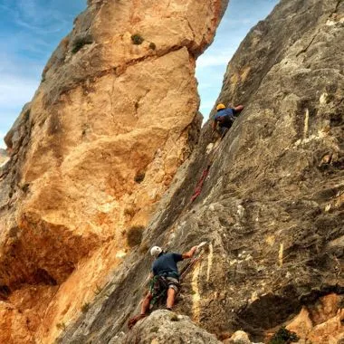
The Pegalajar Climbing Area is one of the most complete and well-established spots in the Sierra Mágina. It is a climbing school on high-quality grey and orange limestone, combining sport climbing, traditional and adventure climbing, and bouldering, in a natural setting close to the town but with a distinct mountain character.

Although the cliffs of the Peña de los Buitres stand out from the motorway linking Jaén and Granada, for years it was a little-visited area. Since 2011, thanks to the ongoing work of local climbers such as José Robles, José E. Carrillo and the Al-hayar Youth Association, the climbing school has developed significantly, especially in the sport climbing and bouldering sectors, becoming today a provincial benchmark.

The variety of styles, orientations and grades makes Pegalajar a suitable destination for both beginners and experienced climbers, provided the sometimes variable rock quality in certain sectors is taken into account.

The sectors and their features are detailed below:
1. Sport climbing sectors
These sectors have modern bolting and single-pitch routes:

  • Iniciación: The sector closest to the village, ideal for beginners. It has between 22 and 23 routes on grey limestone with plenty of pockets and "water drops," with grades ranging from IV to 6c.
  • Arabaico: Located at the foot of the Portichuelo crag, this is an expanding sector with long routes (an 80 m rope is recommended) of great technical quality. It has around 16 routes with grades between IV+ and 7c.
  • Aromático: Located next to the Serrezuela trail, it offers short but intense routes with magnificent views. It has 15 routes with difficulties between 6a and 7a.
  • El Escondite (Sport): A sector that includes routes such as El pecho de un lagarto (6a) and Smile time (7b).

2. Traditional and adventure climbing sectors

Areas of large walls where multi-pitch routes, self-belay and greater technical commitment predominate.

  • Portichuelo: Large cliffs with routes up to 100 metres and 5 pitches. Notable routes include Gripe (6a+) and Bienvenida (6a+).
  • Peña de los Buitres: The main crag, home to committing routes such as D.D.T. (6a+), Manuela (6a) and Fisura Salomón.
  • Peña Grajera: A north-facing sector, located 3 km from the village towards Mancha Real. It features routes such as Diedro Lucifer (6a+) and Ensalada templada (7a+).

3. Bouldering sectors

Pegalajar has more than a hundred boulders, spread across different areas, mainly beneath the Portichuelo. The rock is generally of excellent quality, especially in the beginner sectors, although there are stretches with loose blocks that require caution.

  • Perdigón: The most developed and well-known sector, located in the shade of the pine trees. Due to its size, it is divided into several specific sub-sectors:
    • Rockland: With high-difficulty boulders such as Rockland (8A).
    • La Estrecha: Includes lines such as Serrano Airlines (7A) and Kinderheim 511 (8A).
    • El Capitán: With grade 6 lines and arêtes.
    • El Vacín: Includes boulders such as Sugurus victory (6C) and Sandrova (7B).
    • El Hombre: Boulders such as Levitación (7A) and Aromas de Chefchaouen (6A).
    • Puto Bloke: An area with grade 5 and 6 boulders.
    • Villa Calzones: With boulders such as Kraken (7B) and Lagarto pegalajero (7A).
  • Solera: Located just above Perdigón, on the scree slope beneath the Portichuelo.
  • Peñorares (or Peñonares): A smaller area with more scattered boulders.
  • El Ático: Located next to the Serrezuela trail.
  • Escondite (Boulder): Located near the access to the Arabaico sector.

Warnings and restrictions

  • On the long routes at Portichuelo and Peña de los Buitres, climbing is strictly forbidden from January to July, due to raptor nesting, particularly of the Bonelli's eagle.
  • There are stretches with poor-quality rock and loose blocks, especially on the long routes, so extra caution is recommended.
  • Some equipped long routes are not suitable for beginners and require prior experience, as well as sound route-reading skills.

Orientation and recommended season

The variety of orientations allows for climbing almost all year round, by choosing the sector according to the season.

  • South-facing sectors work well in winter.
  • Peña Grajera, north-facing, is cooler, but not excessively shaded.
  • In the Portichuelo and Peña de los Buitres sectors, climbing is strictly forbidden from January to July. These walls serve as shelter and nesting sites for species such as the Bonelli's eagle.

imagen
Image
escalada pegajalar
Imagen principal
Desactivado
Puntos del trazado
Latitud
37.73634
Longitud
-3.65611
Desactivado

Cambil Via Ferrata

Submitted by brandcode_deweloper on
Breve descripción

The Cambil Via Ferrata is a new addition to the network of via ferratas in the province of Jaén. Located in the municipality of Cambil, this route offers a unique experience combining active tourism with mycotourism and nature. Opened in March 2025, the via ferrata lies to the west of the Mata-Bejid Visitor Centre, on a rocky outcrop. From the visitor centre's car park, a 1,400-metre trail leads to the start of the via ferrata, where the adventure begins.
The Cambil Via Ferrata is known for its three bridges of different sizes (13, 10 and 29 metres), which add an extra challenge for participants, together with a compulsory 39-metre zip line and an 11-metre ladder. Along the route, participants will face slight overhangs and will make use of the rock's natural shapes to progress in a more organic way, adding a unique touch to the experience.
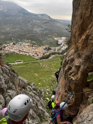
Thanks to its strategic location, the route offers spectacular views of the Sierra Mágina Natural Park. Once the highest point of the route is reached, adventurers can enjoy a flat area to rest before setting off on the zigzagging descent across the meadow, among rocks, until reaching the final obstacle: an equipped descent through the ravine of around 50 metres, which brings us back to the base of the rock face.

Imagen principal
Desactivado
1:30h
Puntos del trazado
Latitud
37.7160
Longitud
-3.5510
Medium
1286m

3,26 km

Desactivado

It is essential to use approved via ferrata-specific equipment (harness, helmet and energy absorber/lanyard). It is recommended to check the weather forecast before the activity, as well as to carry enough water. Although there are no escape routes along the way, the descent is properly equipped.

Al-Manzur Via Ferrata in the Serrezuela de Bedmar

Submitted by brandcode_deweloper on
Descripción larga

The route alternates vertical rock face with an exposed ridge that offers a commanding view over the valley from a privileged position. After the initial stretches of continuous progression, the cable-bridge sector (K4) is reached, more physical and demanding, where balance and arm management are key.
The route culminates with a 65-metre zip line, adding a dynamic and spectacular element before the descent.

Breve descripción

The Al-Manzur Via Ferrata is located in the Serrezuela de Bedmar, at the foot of the Castillo Nuevo, with wide views over the Cuadros river valley and its sea of olive trees. It is a modern facility, opened in September 2025, designed as an active tourism resource to diversify the sporting offer of the region.
It is a very complete route combining vertical sections, an equipped ridge, a more demanding cable-bridge sector (K4) and a final 65-metre zip line. The via ferrata maintains a medium difficulty (K3) along most of the route, with occasional more physical sections and the odd overhang that add intensity and continuity.
Its west-facing orientation and the calm surroundings make it an appealing alternative to other, busier via ferratas in Andalusia.

imagen
Image
escalada
Imagen principal
Activado
imagen
Image
escalada grupo de personas
Imagen principal
Desactivado
imagen
Image
escalada vistas
Imagen principal
Desactivado
4h
Puntos del trazado
Latitud
37.8322
Longitud
-3.4235
Medium
946m
Desactivado

It is essential to use approved via ferrata-specific equipment (harness, helmet and energy absorber/lanyard).
If you do not have the necessary experience and knowledge, it is recommended to hire a certified, qualified guide.
It is advisable to check the weather forecast before the activity and to carry enough water. Although there is an alternative route to avoid getting wet when water flow is high, it doesn't hurt to leave a change of clothes in the vehicle.

Valdepeñas de Jaén – Noalejo – Campillo de Arenas (C1)

Submitted by brandcode_deweloper on
Breve descripción

A long, demanding route linking mountain and countryside, stringing together historic passes, inland valleys and open landscapes. A mixed-surface itinerary, with prolonged climbs and sustained descents, passing through such distinctive spots as the Cañón de los Pitillos, the Piedra del Palo and the Quejigo del Amo, a Natural Monument. Ideal for experienced cyclists seeking variety and terrain.
The route sets off from Valdepeñas de Jaén, leaving the town to climb through olive-grove hillsides and patches of Mediterranean scrubland. The initial ascent leads to the Puerto de los Carboneros, the first pass of the day, which acts as a transition between slopes and opens up the view towards the Sierra Sur. From here, the route strings together quiet, narrow roads, isolated farmhouses and secluded valleys, before tackling the Cuesta de la Burra and the Puerto de los Vinateros, passes historically linked to livestock droving and muleteers.
The route continues towards the Puerto de los Azores, one of the most rewarding viewpoints along the way, then descends through olive groves and open areas to the outskirts of Noalejo, where the landscape softens and allows for a refreshment stop. From here, the route heads towards Campillo de Arenas, alternating secondary roads and rural tracks, always with Sierra Mágina in the background.
The most mountainous stretch comes when the route enters livestock trails and gravel tracks, following old droving routes such as the Cordel de Jaén. It approaches the Cañón de los Pitillos, where the Valdearazo river carves its way between limestone walls, with the option of a detour to the Mirador de la Piedra del Palo, a natural viewpoint over the tail end of the Quiebrajano reservoir. Further on, the path reaches the area around the Quejigo del Amo (or del Carbón), a monumental tree and symbol of the Mediterranean woodland, before heading back towards Valdepeñas de Jaén along traditional paths through olive groves and ravines.
It is a route that demands stamina, but rewards riders with a rich diversity of landscapes, a real sense of the territory, and the feeling of a complete crossing.

imagen
Image
RUTA C1 ATARDECER
Imagen principal
Desactivado
imagen
Image
Ciclista
Imagen principal
Desactivado
imagen
Image
Ciclistas observando la sierra y campiña de Sierra Mágina
Imagen principal
Desactivado
imagen
Image
Sierra Mágina
Imagen principal
Desactivado
imagen
Image
Piedra del Palo
Imagen principal
Desactivado
imagen
Image
ruta
Imagen principal
Activado
6:30
Puntos del trazado
Latitud
37.5900
Longitud
-3.8200
Latitud
37.52902
Longitud
-3.65422
Latitud
37.5553093
Longitud
-3.6354566
Medium

68,1 km

2.801,0
2.801,0
2.734,0
Desactivado

Route recommended for cyclists with good physical fitness. Check the weather forecast, as there are exposed stretches and stony track sections where the surface can vary. Take care on long descents and at road crossings. Carry enough water and respect livestock trails and fencing. On detours to viewpoints, take extra care near cliff edges.

Route card

Km. 0

La ruta parte del casco urbano de Valdepeñas de Jaén y abandona la localidad por el sur. En un giro a la izquierda tomaremos una carretera vecinal asfaltada que avanza entre lomas de olivar. Un segundo giro a la izquierda nos deja en una vía de mayor continuidad, también asfaltada. Tras unos primeros metros de suave rodaje, la carretera comienza a ganar altura progresivamente, dibujando curvas que ofrecen vistas hacia el valle y los montes que rodean la población. Un paisaje que combina olivar en terraza con manchas de encinar y quejigal en umbrías. A medida que ganamos cota, podremos disfrutar de bonitas vistas hacia la Sierra Sur. El camino discurre entre bancales de olivo y manchas dispersas de matorral mediterráneo, recordando el uso agrícola tradicional de estas laderas. Poco a poco, el paisaje se vuelve más abierto y agreste, con laderas pedregosas y pequeñas vaguadas. El Puerto de los Carboneros (1.340 m) se alcanza al coronar la divisoria, en un collado amplio que actúa de paso natural entre vertientes. Es un buen punto para breve parada: resguardo del viento, ofrece panorámica de sierras calizas subbéticas y marca el final del ascenso principal de este primer tramo.

Km. 4,2

Desde el Puerto de los Carboneros (1.340 m), la ruta continúa en dirección noroeste, por una estrecha carretera asfaltada que desciende suavemente al inicio. A poco más de un kilómetro, el camino bordea el Cortijo de los Carbonerillos, situado a mano derecha, junto al Arroyo de Carboneros, que da nombre al valle y se convierte en una referencia acústica y visual de este tramo. Este cortijo es ejemplo de arquitectura rural ligada al aprovechamiento agrícola y ganadero de estas sierras. Superado este enclave, el trazado gira levemente hacia el norte y comienza a ganar altura de forma progresiva. El perfil se endurece a medida que la carretera serpentea en sucesivas curvas, flanqueada por laderas cubiertas de monte bajo y pinares de repoblación, que se alternan con claros y pequeños barrancos. En el tramo final, la orientación vuelve a ser noroeste, afrontando las rampas más sostenidas que conducen hasta la Cuesta de la Burra (1.440 m). Este collado natural ofrece un respiro al ciclista y una panorámica amplia: hacia el este se distinguen los valles que descienden hacia el río Valdearazo, mientras que hacia el oeste la mirada se abre hacia la campiña olivarera de la Sierra Sur.

Km. 11,5

Desde la Cuesta de la Burra, la ruta continúa en dirección sureste por un camino asfaltado estrecho que se abre paso entre lomas de olivar y manchas dispersas de matorral mediterráneo. El ascenso es moderado, con tramos de subida continuada que exigen pedaleo constante, aunque sin pendientes fuertes. Tras unos dos kilómetros de avance, el itinerario deja a la izquierda varias antiguas caserías vinculadas a la explotación del monte y a la pequeña ganadería tradicional. A lo largo del camino se distinguen barrancos y vaguadas donde aflora la vegetación de ribera —zarzas, adelfas y algún taray—, que contrasta con la monotonía olivarera del entorno. El relieve se hace más abierto conforme nos aproximamos al Puerto de los Vinateros, paso natural situado a unos 2’5 km del inicio del tramo.

Km. 13

Este collado recibe su nombre por ser, según la tradición, lugar de tránsito de arrieros y vinateros que cruzaban entre las sierras y la campiña. Desde este punto, las vistas se amplían al suroeste, hacia la campiña y las laderas que descienden al valle. Desde el Puerto de los Vinateros, el itinerario prosigue en dirección suroeste por un camino de montaña, con un perfil ascendente que gana altura de forma constante. La carretera se estrecha y serpentea entre laderas de olivar y manchas de monte bajo, donde reaparecen encinas y quejigos y es posible encontrar formaciones de matorral mediterráneo como coscojas, lentiscos y jaras. Encontraremos que durante unos 1’9 km el trazado coincide con parte del trazado de GR7. El trazado mantiene una subida progresiva, con algún tramo de mayor pendiente que requiere esfuerzo constante al ciclista. Tras recorrer unos 4,5 km desde el collado anterior, se alcanza el Puerto de los Azores, otro paso natural que conecta estas sierras interiores y que constituye un excelente mirador sobre la Sierra Sur de Jaén.

Km. 18

Desde el puerto, la ruta inicia un descenso moderado en dirección noreste, avanzando por una estrecha carretera asfaltada que se desliza entre vaguadas y lomas suaves. A medida que se pierde altitud, aparecen las primeras referencias del parque eólico Sierra del Trigo, con sus aerogeneradores dominando el horizonte. El recorrido alterna tramos de bajada con suaves ondulaciones, rodeado por un mosaico de olivar y zonas despejadas que evidencian la vocación agrícola del territorio. Finalmente, tras unos 3,8 km de pedaleo, se alcanza la subestación del parque eólico, punto de referencia clara en este sector de la ruta.

Km. 23,5

Desde la subestación del parque eólico, el recorrido continúa en dirección este-noreste unos 5 km por una carretera asfaltada. El trazado avanza entre lomas cubiertas de olivar, intercaladas con manchas de vegetación mediterránea donde prosperan coscojas, jaras y tomillos. El perfil, favorable en algunos tramos, mantiene un suave descenso que permite disfrutar de panorámicas abiertas hacia el valle a medida que alcanzamos las inmediaciones de Navalcán.

Km. 29,6

Desde el paraje de Navalcán, la ruta inicia un descenso progresivo siguiendo un firme de camino rural asfaltado que discurre entre lomas de olivar. El trazado se abre con amplias vistas hacia el valle que se extiende frente a Noalejo, mientras a la espalda quedan los relieves de Sierra Mágina. El camino, cómodo y sin grandes pendientes, avanza entre cortijos dispersos y parcelas de olivar que ocupan casi por completo estas tierras de transición entre la sierra y la campiña. A lo largo del descenso, se atraviesan pequeños barrancos de escorrentía, modelados por la erosión y flanqueados por vegetación mediterránea adaptada a la aridez. Finalmente, tras unos 5’3 km desde Navalcán la ruta alcanza el núcleo urbano de Noalejo, entrando por la zona baja del municipio y remontando ligeramente hasta el centro urbano. El entorno de la Plaza de España es un buen punto para avituallarse y ajustar la ruta antes de continuar hacia el este en dirección a Campillo de Arenas.

Km. 33,8

Abandonamos el tramo urbano de Noalejo por la JV-2229 hasta alcanzar el cruce con la N-323, donde tomamos dirección a Campillo de Arenas. Desde este punto, la ruta prosigue por la nacional durante unos 4,5 km en firme asfaltado y de cómodo pedaleo. El itinerario avanza paralelo a la ladera norte de Sierra Mágina, entre un mosaico de olivares en pendiente y pequeños cortijos dispersos que recuerdan el carácter agrícola de esta zona. La carretera, de trazado sinuoso pero cómodo, desciende de manera progresiva siguiendo el corredor natural que conecta ambos municipios. En el horizonte se van perfilando los cerros que protegen Campillo de Arenas, al aproximarnos a la localidad, podremos reconocer el cerro coronado por su castillo medieval, hito visual que anuncia la llegada al municipio. El acceso a Campillo de Arenas se realiza tras un suave descenso final, entrando al municipio por la N-323 y alcanzando sus primeras calles tras unos 4,2 km desde Noalejo. Abandonamos Campillo de Arenas dirigiéndonos al noroeste por la calle Barranquillo hacia la calle Acera del Río. Tras recorrer unos 130 m, giramos a la izquierda para incorporarnos a la JV-2228. Apenas 600 m después, tomamos un carril a la derecha que nos conducirá progresivamente hacia las lomas que cierran el valle. El firme es inicialmente asfaltado, aunque pronto pasa a ser un carril de zahorra compactada, con un trazado cómodo en suave ascenso. Los olivares dominan el paisaje en los primeros kilómetros, hasta que aparecen zonas de monte bajo, plantaciones de almendros y pinares de repoblación que recuerdan la vocación forestal de estas sierras. Este camino coincide en varios tramos con cordel de Jaén, vía pecuaria de gran tradición en la comarca, utilizada durante siglos para la trashumancia y el movimiento de ganados entre la campiña y las sierras. El firme presenta tramos pedregosos e irregulares que requieren precaución en la marcha. El itinerario continúa por el Cordel de Jaén hasta alcanzar una bifurcación claramente señalizada. Si tomáramos el desvío a la derecha, podríamos enlazar con Carchelejo y con la ruta cicloturista C2; mientras que este trazado que recorremos conecta con un tramo del GR 7, perfectamente balizado y coincide con el comienzo de la ruta de senderismo que nos conducirá a la Piedra del Palo. En nuestro caso seguimos de frente, avanzando hacia el Cortijo del Cortijuelo, que se alza como punto de referencia en el camino. La senda gana altura suavemente hasta aproximarse al collado de la Cañada del Sabinar y el paraje del Cañón de Pitillos, labrado por el río Valdearazo. El Valdearazo se encajona de forma espectacular entre altas paredes calizas, describiendo varios meandros que hacen aún más impresionante el cañón. Curiosas formaciones pétreas salpican todo este paraje, como la piedra del Palo, una formación rocosa singular que se erige como hito natural del recorrido y lugar de parada obligada para quienes buscan disfrutar de la grandeza del paisaje y de la naturaleza. A ella podremos llegar tomando un desvío a la izquierda de nuestra marcha que nos conduce al Mirador de la Piedra del Palo.

Km. 50,3

Desde las inmediaciones del Cañón de los Pitillos, la ruta prosigue en dirección suroeste, afrontando un ascenso progresivo por pista pedregosa que requiere precaución en la marcha. El camino se abre paso entre laderas de matorral mediterráneo y coscojares, con tramos donde el desnivel se hace más evidente. Tras recorrer unos 5 km, se alcanza el Collado de los Yeros, paso natural que comunica varios barrancos y ofrece una buena panorámica de las umbrías cercanas. El camino está salpicado de un abrupto paisaje típico mediterráneo con bosques de encinas, alcornoques, pinos y quejigos centenarios, pero de entre todos ellos destaca el Quejigo del Amo o del Carbón. Desde este collado, el itinerario desciende suavemente durante el primer kilómetro, siempre en rumbo oeste-suroeste, bordeando laderas más abiertas. El firme continúa siendo irregular, con presencia de piedra suelta. Poco después, la pendiente se invierte y comienza un desnivel continuo hacia el siguiente hito. Tras un total de 2,7 km desde el collado, se llega al entorno del Quejigo del Amo o del Carbón, ejemplar monumental de gran porte y longevidad. Situado en el municipio de Valdepeñas de Jaén, fue declarado Monumento Natural en 2001. Este ejemplar representativo de la vegetación autóctona mediterránea, está considerado como uno de los de mayores dimensiones del territorio andaluz. Este quejigo constituye no solo un valor natural de primer orden, sino también un símbolo etnográfico ligado a los antiguos usos del monte.

Km. 57

Desde el entorno del monumental Quejigo del Amo, la ruta inicia un tramo descendente que avanza en dirección suroeste. El firme es pedregoso en varios puntos, por lo que conviene extremar la precaución, sobre todo en épocas húmedas. El recorrido atraviesa laderas de monte mediterráneo y olivares hasta alcanzar el Collado del Cañón, paso natural que ofrece amplias vistas hacia los barrancos próximos. A partir de aquí la marcha prosigue entre repechos suaves, alternando descensos y ligeras subidas, hasta alcanzar el Collado de Navalayegua, punto estratégico desde donde se abre el horizonte hacia las estribaciones que rodean Valdepeñas de Jaén. Los últimos kilómetros discurren por caminos tradicionales, entre olivares y pequeños barrancos, recordando la estrecha relación entre este territorio y los usos agrícolas y ganaderos que lo han modelado durante siglos.

Km. 67,7

Finalmente, el itinerario se adentra de nuevo en el núcleo urbano de Valdepeñas de Jaén, cerrando el circuito circular. El regreso al punto de partida permite al ciclista valorar la diversidad de paisajes atravesados: desde los collados serranos y los hitos naturales —como la Piedra del Palo o el Quejigo del Amo— hasta las laderas de olivar y los pasos tradicionales de las vías pecuarias. Un recorrido exigente en su kilometraje y desnivel, pero de gran riqueza cultural, natural y etnográfica, que resume la esencia de Sierra Mágina.

Blood Sausage

Submitted by brandcode_deweloper on
REC-29
imagen
Image
morcilla%20de%20res_sm%20%281%29.jpg
Imagen principal
Activado
Morcilla de res (blood sausage) is a traditional cured product from Albanchez de Mágina, especially associated with winter and the pig-slaughtering season. Made with lamb blood and meats, spices and natural casing, it is part of that intense, hearty mountain cuisine designed for the coldest months. Its preparation combines the cooking of lamb trotters and tripe with a traditional sofrito of vegetables and spices, in which extra virgin olive oil with PDO Sierra Mágina adds flavour and character to the dish. It is served hot, as a winter recipe full of tradition and local character.
Desactivado
Lamb blood, Suet, Lamb trotters and tripe, Onion, Garlic, Tomato, Fresh pepper, Oregano, Clove, Cumin, Aniseed, Cinnamon, Pepper, Paprika, Chilli, Salt, Extra virgin olive oil PDO Sierra Mágina

Mojili torreño

Submitted by brandcode_deweloper on
REC-28
Distrito
Municipio
Mojili torreño is a traditional dish from Torres, simple and closely tied to popular, resourceful cuisine. It is made with potatoes cut into thin slices, fried in the same oil in which a slice of bread, garlic and choricero peppers have previously been browned. With the fried bread, garlic, choricero peppers and some cumin, a crushed mixture is prepared, which is then added to a broth in which the already fried potatoes are cooked for a few minutes. The result is a humble, tasty dish with the character of age-old home recipes.
Desactivado
Potatoes, Bread, Garlic, Choricero peppers, Cumin, Olive oil, Water or stock, Salt

Fried Flour Crumbs

Submitted by brandcode_deweloper on
REC-27
Distrito
Municipio
imagen
Image
migas_de_trigo_sm.jpg
Imagen principal
Activado
Migas de harina (fried flour crumbs) is one of the most characteristic recipes of Cambil and Arbuniel and of the region's traditional cuisine. Unlike other versions, in Cambil they are usually formed into a large golden cake, prepared slowly in a pan and worked patiently until achieving its characteristic texture. Preparation begins by heating extra virgin olive oil with PDO Sierra Mágina, in which the garlic, pork belly, chorizo and peppers are fried and then set aside. Water, salt and flour are added to that same oil, stirring constantly until the dough cooks, comes away from the pan and starts to brown. Finally, a cake is formed and flipped so it browns on both sides. Once ready, it is served with the reserved pork belly, chorizo and peppers. Traditionally it can also be served with fruit such as melon, grapes or orange, creating that contrast between savoury and fresh so typical of popular cuisine.
Desactivado
Flour, Pork belly/bacon, Chorizo, Garlic, Peppers, Extra virgin olive oil PDO Sierra Mágina, Salt

Hornazos (Easter Egg Bread)

Submitted by brandcode_deweloper on
REC-26
Distrito
Municipio
imagen
Image
hornazo_sm.jpg
Imagen principal
Activado
Hornazos are a traditional preparation from Bedmar and Garcíez and other areas of Jaén, especially associated with Easter. They are made with a bread dough enriched with olive oil and aniseed, which wraps around one or more whole boiled eggs before baking. Their decorated shape and festive character make hornazos a recipe closely tied to family celebrations and popular seasonal baking. The optional use of extra virgin olive oil with PDO Sierra Mágina adds flavour and reinforces the link with the area's olive-growing tradition.
Desactivado
Flour, Eggs, Aniseed, Extra virgin olive oil PDO Sierra Mágina, Salt, Yeast, Sugar (optional)