Saltar al contenido principal
icon-intereses-gastronomia

Iglesia de San Francisco de Paula

Submitted by brandcode_deweloper on
Id
3966027
Descripción
Breve descripción
The parish church of Torrequebradilla stands out as the most significant cultural asset in the town centre. It has a nave with a gabled roof covered in Arabic tiles; a slightly pronounced transept, in keeping with its Latin-cross floor plan, marked by a dome covered externally with a hipped roof; and a bell gable that marks the church's highest point.
Telecomunicaciones
Sitio web
www.villatorres.es/patrimonio-historico/
Ubicación
Código Postal
23638
Latitud
37.91060
Longitud
-3.66297
Dirección
Plaza Mayor, 5
Municipio
Ubicación en el mapa
POINT (-3.66297 37.9106)
Imágenes carrusel
imagen
Image
francisco%20de%20paula.jpg
Imagen principal
Desactivado
Imágenes cabecera
imagen
Image
2053553j9.jpg
Imagen principal
Activado
Loading map
Preparing points of interest and routes...

Ermita del Santo Cristo de la Salud

Submitted by brandcode_deweloper on
Id
3964271
Descripción
Descripción larga
The popular veneration of the titular Christ is linked to a deadly plague epidemic that devastated the town in 1833, which subsided after residents agreed to carry the image of the Crucified Christ in procession, after which the epidemic receded and the sick recovered. In thanksgiving, the hermitage was remodelled, its features of interest being the ashlar semicircular-arched doorway and the single-tier bell gable, and the dedication of its titular image was changed.
Breve descripción
Outside the town walls, the hermitage of Santa Ana was built between the 16th and 17th centuries, using stones from the Iberian ruins of Maquiz; it was converted at the end of the 19th century into the hermitage of the Santo Cristo de la Salud.
Telecomunicaciones
Sitio web
http://www.parroquiavillargordo.es/
Teléfono de contacto
953 37 70 00
Ubicación
Código Postal
23630
Latitud
37.94571
Longitud
-3.73042
Dirección
C/ 14 de Abril s/n
Municipio
Ubicación en el mapa
POINT (-3.73042 37.94571)
Tipos de punto de interés
Imágenes carrusel
imagen
Image
Ermita%20del%20Santo%20Cristo%20de%20la%20Salud.png
Imagen principal
Desactivado
Imágenes cabecera
imagen
Image
MG_9427.jpg
Imagen principal
Activado
Loading map
Preparing points of interest and routes...

Museo Cerezo Moreno

Submitted by brandcode_deweloper on
Id
2279093
Descripción
Descripción larga
Francisco Cerezo was a figurative painter and one of the finest contemporary still-life painters. The exhibition also features the La Granja Glass Collection, the most important of its kind after that of the La Granja de San Ildefonso Museum itself, in Segovia. A highly prolific painter, towards the end of his life he still owned a large amount of his own work, at which point he offered his entire collection to the town of Villargordo on condition that a permanent exhibition be set up. The museum has five rooms, two on the ground floor and three on the first floor. One of the rooms is dedicated to other painters from Jaén, displaying works by several generations of artists, all connected to the museum's namesake. The other rooms are devoted to landscape, portraiture, still life, and to Segura de la Sierra, a town in Jaén where Francisco Cerezo studied and produced much of his work, especially mountain landscapes and miniature panel paintings reminiscent of the early Flemish masters. Display cases in the rooms hold an important collection of La Granja de San Ildefonso glassware, likewise owned by the painter, of great significance both in quantity and in the quality of the pieces.
Breve descripción
The Cerezo Moreno Museum in Villargordo is housed in the old town hall building, overlooking the town's main square. It is a monographic museum dedicated to the local painter Francisco Cerezo Moreno, displaying more than 150 of his works.
Telecomunicaciones
Sitio web
https://museo.villatorres.es/
Ubicación
Código Postal
23630
Latitud
37.93871
Longitud
-3.72942
Dirección
Museo Cerezo Moreno
Municipio
Ubicación en el mapa
POINT (-3.72942 37.93871)
Tipos de punto de interés
Imágenes carrusel
imagen
Image
main_image_65897.jpeg
Imagen principal
Desactivado
imagen
Image
3.jpg
Imagen principal
Desactivado
imagen
Image
22181235_280726989087832_6942261374176704497_o.jpg
Imagen principal
Desactivado
Imágenes cabecera
imagen
Image
image_276034.jpeg
Imagen principal
Activado
Horario
Tuesday to Friday: 4:00 pm to 8:30 pm. Saturdays and Sundays: 10:00 am to 2:00 pm and 4:00 pm to 8:30 pm.
Loading map
Preparing points of interest and routes...

Charca de Pajarejos

Submitted by brandcode_deweloper on
Id
4521732
Descripción
Descripción larga
Location: North-east of the town, close by. Distance: 5 km. Means of access: By car, by bicycle or on foot. Access route: Directly from the town, leaving via the JV-2.334 towards Fuerte del Rey.
Breve descripción
This natural pond, which only forms after heavy rainfall, functions as a temporary wetland ecosystem where various waterbirds nest.
Ubicación
Código Postal
23659
Latitud
37.83971
Longitud
-4.00149
Dirección
Villardompardo
Distrito
Municipio
Ubicación en el mapa
POINT (-4.00149 37.83971)
Imágenes carrusel
imagen
Image
Charca%20de%20Pajarejos3.jpg
Imagen principal
Desactivado
imagen
Image
Charca%20de%20Pajarejos.jpg
Imagen principal
Desactivado
Imágenes cabecera
imagen
Image
1539949207_996559_1539949275_noticia_normal.jpg
Imagen principal
Activado
Loading map
Preparing points of interest and routes...

La Ermita de la Virgen de Atocha

Submitted by brandcode_deweloper on
Id
4521662
Descripción
Descripción larga
Around the 18th century, the hermitage of the Virgen de Atocha was built over the remains of a cemetery. We do not know exactly the date or year of her apparition, but it is linked to the apparition of the Virgen de Atocha of Madrid, as both refer to the same Virgin. The story goes back a long way, as oral tradition holds that one day the great Lady appeared where her hermitage now stands. Seeing that it was the same Virgen de Atocha venerated in Madrid, people decided to return her to the Spanish capital. She appeared again at the same spot, and once again they took her to Madrid, and so on, until they decided to leave her here, as she seemed unwilling to leave Villardompardo — and so it was, once her hermitage was built. Over the years, all the people of Villardompardo came to worship her and hold great faith in her.
Breve descripción
The hermitage of Nuestra Señora de Atocha, in Villardompardo, is a small church which, according to legend, was built atop the hill on which the Virgin appeared — a spot that had been an old esparto field with seven olive trees. The current image is a replica of the original, which was destroyed during the Civil War.
Telecomunicaciones
Sitio web
www.villardompardo.es
Teléfono de contacto
953 57 60 07
Ubicación
Código Postal
23659
Latitud
37.83886
Longitud
-4.00065
Dirección
Calle Virgen de Atocha, 23
Distrito
Municipio
Ubicación en el mapa
POINT (-4.00065 37.83886)
Tipos de punto de interés
Imágenes carrusel
imagen
Image
Las%20ermitas%20de%20la%20Virgen%20de%20Atocha.jpg
Imagen principal
Desactivado
imagen
Image
Las%20ermitas%20de%20la%20Virgen%20de%20Atocha2.jpg
Imagen principal
Desactivado
Imágenes cabecera
imagen
Image
ermita.jpg
Imagen principal
Activado
Loading map
Preparing points of interest and routes...

Iglesia de Nuestra Señora de Gracia

Submitted by brandcode_deweloper on
Id
4521600
Descripción
Breve descripción
Dating from the 16th century and located in the centre of the municipality, it was built of masonry and reinforced with side buttresses. It consists of a central nave and a chapel. The doorway features a simple, stylised semicircular arch, above which sits a sculpture-less niche closed off with a small triangular pediment. Composed of a single nave decorated with a 17th-century coffered ceiling, now hidden beneath mid-20th-century barrel-vaulted domes. It probably originated with a monastic purpose, although no religious community ever came to settle here.
Telecomunicaciones
Teléfono de contacto
953576603
Ubicación
Código Postal
23659
Latitud
37.83960
Longitud
-4.00094
Dirección
Plaza Constitución, 0
Distrito
Municipio
Ubicación en el mapa
POINT (-4.00094 37.8396)
Tipos de punto de interés
Imágenes carrusel
imagen
Image
Iglesia%20de%20Nuestra%20Se%C3%B1ora%20de%20Gracia_Villadompardo.jpg
Imagen principal
Desactivado
Imágenes cabecera
imagen
Image
iglesia.jpg
Imagen principal
Activado
Loading map
Preparing points of interest and routes...

Villardompardo Castle

Submitted by brandcode_deweloper on
Id
4521326
Descripción
Descripción larga
In the area where the castle stands, dwelling and storage structures (a hydraulic feature, silos and hut floors) belonging to a Copper Age settlement have been documented. Of the Roman settlement, a double walled enclosure can be identified, protected by a moat on the northern side that reinforced its defences. It was probably organised around a tower located to the south-west, to which the large-sized masonry blocks forming the foundations of the medieval tower would correspond. Inside, buildings would have stood, of which few traces remain, with storage structures for agricultural produce and water. The medieval fortress, built between the 13th and 14th centuries making use of Roman-period remains, consisted of a walled enclosure in the shape of an irregular trapezoid, with four towers, of which three survive today: a large rectangular tower occupying the south-western corner; a small, circular one to the north-west, of which only the base survives; and another rectangular, solid one to the north-east, which defended the castle gate. A fourth tower once stood at the south-eastern corner, lost in the 19th century. The complex is built of masonry, except for the southern wall, which is built in rammed earth. The south-western tower, or keep, is divided into three floors plus a ground floor, occupied by a cistern. In some parts of the keep, traces can still be seen of the original decoration that would have covered the walls of the fortification — a pattern of leaves or drops using sgraffito techniques, decoration that would also have covered the walls and the solid tower. The tower's original door was heavily defended, double-leaved, and would have had a machicolation-like opening for pouring liquids or stones onto attackers, as well as a portcullis. This access was sealed off when a cistern was built inside the tower, occupying almost the entire ground floor. The vaulted roof of the cistern has disappeared, but two related elements survive: a settling structure and a well for drawing water. The archaeological excavations that uncovered this water tank also recovered the original staircase embedded in the tower's north wall. Both can be seen during a visit, and it is possible to walk over the cistern. The climb up the tower ends at the terrace, which offers wide visual control of the surrounding territory, with views of sites such as El Berrueco, Andújar, Arjona and Martos — explaining why this location was chosen for the fortification. Its position on a steep slope acted as a natural defence, but the northern and western sides, being more accessible, were protected by a wide moat around 7 m across and up to 2.10 m deep, hidden until it was uncovered during recent archaeological work. The moat ran between two towers reinforced with scarps that are still visible. From the 16th century onwards, a new door was opened in the western wall, with a Renaissance doorway carved in ashlar stone that survives today. It consists of two sections: the lower one with a semicircular arch on pilasters, and the second with a large rectangular panel at its centre, bearing the coat of arms of Don Fernando de Torres and his first wife, Doña Francisca de Carvajal y Osorio. The greatest transformation was the construction of wings attached to the walls, forming a large residential space. The Keep and the southern wall retain openings that would have connected them. Today, the ground floors of these structures can still be identified, although they would originally have reached two or three storeys in height. These wings housed the palace's "privileged space" — that is, the rooms of the Count and Countess, the chapel, the crypt, the entrance hall and a gallery-corridor or atrium, in the western wing — while in the southern building, the ground floor was used for storage, with the first floor reserved for the palace's main representative space, a large hall with a fireplace carved into the tower's façade. The structures to the north and east would have been dedicated mainly to service functions, including stables, kitchens and a cellar. Archaeological work confirmed the existence of a prehistoric, Copper Age settlement on the hill where the castle now stands. The presence of sickle teeth, mills and storage silos points to an agricultural economy based on cereal farming. A hydraulic structure, underground dwelling features and post-hole structures have also been found. There does not appear to have been continuous occupation of the site, suggesting the settlement must have been temporarily abandoned. From the early 1st century BC to the 2nd century AD, there was an increase in agricultural settlements devoted to cereal farming across the countryside. During this period, the site was reoccupied as a fortified settlement, reaching its peak between the first quarter of the 1st century and the 2nd century AD, after which it was abandoned once again. In the late Middle Ages, the term "villar" identified a place with the remains of an abandoned ancient settlement. Following the conquest of the territory, the Castilians settled here while Roman structures were still visible, choosing to reuse some of them, along with building material, to construct the castle. The hamlet of El Villar de Don Pardo is already mentioned in sources in 1251, but the castle was not built until the late 13th or early 14th century, with the fortification first referred to in 1416, as a place still belonging to the Council of Jaén. Fernando Ruiz de Torres later obtained the cession of the hamlet. In the second half of the 15th century, with Teresa de Torres — married to the Constable of Castile, Miguel Lucas de Iranzo — as lady of the estate, Villardompardo became one of the defensive lines of the supporters of Henry IV against the rebellious nobility, led in the area by the Order of Calatrava. The death of her son without heirs passed the lordship to a side branch of the Torres family, which married into the family of Peter I of Portugal. Philip II made it the seat of a county when he named Don Fernando de Torres y Portugal Count of Villardompardo in 1576. Between the late 16th and early 17th centuries, the castle was converted into a palace, serving as the usual residence of the counts. Their successors, however, settled at Court in Madrid, which began a process of decline through lack of maintenance. The abolition of entailed estates under the reign of Ferdinand VII forced the inheritance to be divided, separating Villardompardo Castle from the main noble line. In the late 19th or early 20th century, the 16th-century buildings were demolished, leaving only the perimeter walls, levelling the surface and carving steps into the northern wall to temporarily turn the enclosure into a bullring. The castle has undergone various emergency consolidation works, archaeological excavations and restoration between 2012 and 2023.
Breve descripción
Villardompardo Castle, built between the 13th and 14th centuries, is a walled enclosure built mostly of masonry. It was marked by four towers, the most notable being the great keep, and was protected on its north-western side by a moat. From the 16th century onwards, the fortress underwent a profound transformation, eventually becoming a large rural building, the palace-residence of the Counts of Villardompardo, notable for its monumental doorway and the cistern occupying the ground floor of the tower. The site on which it stands was once home to a Copper Age settlement and a fortified Roman settlement dated between the early 1st and 2nd centuries AD, of which numerous structures survive. Following the Castilian conquest of this territory, the Castilians built a fortress that played an important role in the noble power struggles of the 15th century, becoming one of the defensive lines of the supporters of Henry IV. Philip II made it the seat of a county when he named Don Fernando de Torres y Portugal Count of Villardompardo in 1576.

Telecomunicaciones
Sitio web
www.villardompardo.es/el-municipio/patrimonio-historico.html
Correo electrónico
villardompardo@promojaen.es
Ubicación
Código Postal
23659
Latitud
37.83912
Longitud
-3.99972
Dirección
Villardompardo, Jaén
Distrito
Municipio
Ubicación en el mapa
POINT (-3.99972 37.83912)
Tipos de punto de interés
Imágenes carrusel
imagen
Image
Castillo%20de%20Villardompardo2.jpg
Imagen principal
Desactivado
imagen
Image
Castillo%20de%20Villardompardo5.jpg
Imagen principal
Desactivado
imagen
Image
Castillo%20de%20Villardompardo13.jpg
Imagen principal
Desactivado
imagen
Image
Castillo%20de%20Villardompardo9.jpg
Imagen principal
Desactivado
Imágenes cabecera
imagen
Image
Castillo%20de%20Villardompardo14.jpg
Imagen principal
Activado
Microsite al que pertenece
Loading map
Preparing points of interest and routes...

Iglesia Parroquial de San José

Submitted by brandcode_deweloper on
Id
4897477
Descripción
Breve descripción
Built in the mid-20th century. The interior is accessed through a semicircular arch, above which sits a circular window, topped by a pyramid-shaped bell gable with three bells and a whitewashed façade. Inside, the altarpiece has three sections with three niches, separated by columns and topped with pinnacles. The central niche houses the patron saint.
Telecomunicaciones
Sitio web
www.torreblascopedro.es
Teléfono de contacto
953 62 60 80.
Ubicación
Código Postal
23510
Latitud
37.99745
Longitud
-3.63695
Dirección
Parroquia de San José Paseo del Ayuntamiento, 19
Municipio
Ubicación en el mapa
POINT (-3.63695 37.99745)
Tipos de punto de interés
Imágenes carrusel
imagen
Image
Iglesia%20Parroquial%20de%20San%20Jos%C3%A9.jpg
Imagen principal
Desactivado
imagen
Image
Iglesia%20Parroquial%20de%20San%20Jos%C3%A92.jpg
Imagen principal
Desactivado
Imágenes cabecera
imagen
Image
00001083.jpg
Imagen principal
Activado
Loading map
Preparing points of interest and routes...

Iglesia Parroquial de la Asunción de Nuestra Señora

Submitted by brandcode_deweloper on
Id
4897653
Descripción
Breve descripción
The most notable building in Campillo del Río is the parish church, representative of post-war colonisation architecture. It has a rectangular floor plan and a very spacious interior. Externally, the presbytery is built in exposed brick, while the rest of the building is whitewashed. It was built in 1953 and has recently undergone improvement works.
Telecomunicaciones
Sitio web
www.andalucia.org/es/villacarrillo-turismo-cultural-parroquia-de-nuestra-senora-de-la-asuncion-3
Teléfono de contacto
953636012
Ubicación
Código Postal
23510
Latitud
37.99782
Longitud
-3.63529
Dirección
Torreblascopedro, Jaén
Municipio
Ubicación en el mapa
POINT (-3.63529 37.99782)
Tipos de punto de interés
Imágenes carrusel
imagen
Image
Iglesia%20Parroquial%20de%20la%20Asunci%C3%B3n%20de%20Nuestra%20Se%C3%B1ora.jpeg
Imagen principal
Desactivado
imagen
Image
Iglesia%20Parroquial%20de%20la%20Asunci%C3%B3n%20de%20Nuestra%20Se%C3%B1ora2.jpeg
Imagen principal
Desactivado
Imágenes cabecera
imagen
Image
image_230775.jpg
Imagen principal
Activado
Loading map
Preparing points of interest and routes...

Casas Señoriales

Submitted by brandcode_deweloper on
Id
4897406
Descripción
Breve descripción
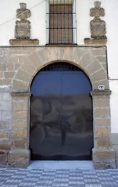
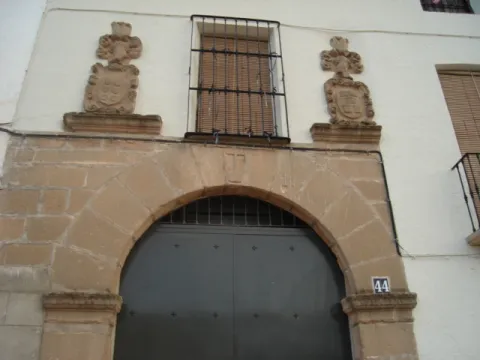
The oldest building within the town centre, built with rendered masonry, is a traditional Andalusian noble house, three storeys high and of large dimensions. The ground-floor windows have wrought-iron grilles with lead ornamentation, and the five balconies on the upper floor rest on corbels, with iron parapets and trapezoidal moulding. Engraved on the lintel of one of the windows is the date 1714. The entrance door, framed with a jamb, is off-centre. Next to this house is another, with a doorway featuring a semicircular arch resting on impost blocks and a cross at the keystone. The original ashlar stonework has disappeared, but above the arch a barred window survives, flanked by 17th-century Baroque-style stone coats of arms.
Telecomunicaciones
Sitio web
www.torreblascopedro.es
Teléfono de contacto
953626001
Correo electrónico
torreblascopedro@jaen.com
Ubicación
Código Postal
23510
Latitud
37.99658
Longitud
-3.63589
Dirección
C/ Constitución nº 42
Municipio
Ubicación en el mapa
POINT (-3.63589 37.99658)
Imágenes carrusel
imagen
Image
Torreblascopedro.jpg
Imagen principal
Desactivado
Imágenes cabecera
imagen
Image
Portada_de_la_Casa_Se%C3%B1orial.jpg
Imagen principal
Activado
Loading map
Preparing points of interest and routes...