Saltar al contenido principal
icon-intereses-cultura

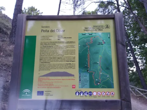
Circular Route Peña del Olivar

Submitted by brandcode_deweloper on
Id
5973466
Breve descripción

Northern area of the Natural Park, municipality of Siles.

Latitud
38.3883
Longitud
-2.5817
Distrito
Municipio
Ubicación en el mapa
POINT (-2.5817 38.3883)
imagen
Image
1.jpg
Imagen principal
Activado
imagen
Image
Ruta%20Circular%20Pe%C3%B1a%20del%20Olivar.jpg
Imagen principal
Desactivado

Nature

icon-intereses-naturaleza

Friends

icon-intereses-amigos

Adventure

icon-intereses-aventura

Culture

icon-intereses-cultura

Sport

icon-intereses-deporte

Eco-friendly

icon-intereses-eco-friendly

For couples

icon-intereses-en-pareja

Family

icon-intereses-familia

Gastronomy

icon-intereses-gastronomia

Municipality

icon-intereses-municipio

Low-cost tourism

icon-intereses-turismo-low-cost

Solo travel

icon-intereses-viajar-solo
Medium
Document
Document
Ruta Circular Peña del Olivar
1,3 km
4480m
All year round
Desactivado

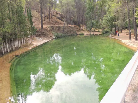
In the recreational area of La Peña del Olivardis it puts the fountain, tables, bathing area and a kiosk that usually opens during the holiday period. There is also water in the Nogueron Fountain (Km 1),

From Siles: on the JF-7012 road, marked "The Way of the Azeas."

Recreative area of the Peña del Olivar, in the Km 2 of the said road, next to the ceramic panel.

Circular Route Navalespino

Submitted by brandcode_deweloper on
Id
5972751
Descripción larga

From Segura de la Sierra we take the Sierra road (JV-7032), and at 8.3 km we find a crossing called La Era del Fustal, where we turn right, towards Santiago de la Sword. About 400? m later we took to the left a long forest track that flows into the Albaceteña village of Parolís. It is a wide track and in good condition, at the beginning of which there are signs of speed and weight limitation.

From Siles we take the road called the Road of the Azebeas (JF-7012). At 14 Km we arrive at the crossing that goes to Segura de la Sierra on the right (The Era del Fustal). We ignore it and continue to face it by finding about 400? m to the left the forest track mentioned above.

Latitud
38.276424
Longitud
-2.543725
Distrito
Municipio
Ubicación en el mapa
POINT (-2.543725 38.276424)
imagen
Image
2.jpg
Imagen principal
Activado
imagen
Image
turismoActivo9.jpg
Imagen principal
Desactivado
2 h 30 min

Nature

icon-intereses-naturaleza

Friends

icon-intereses-amigos

Adventure

icon-intereses-aventura

Culture

icon-intereses-cultura

Sport

icon-intereses-deporte

Eco-friendly

icon-intereses-eco-friendly

For couples

icon-intereses-en-pareja

Family

icon-intereses-familia

Gastronomy

icon-intereses-gastronomia

Municipality

icon-intereses-municipio

Low-cost tourism

icon-intereses-turismo-low-cost

Solo travel

icon-intereses-viajar-solo
Medium
Ruta Circular Navalespino
7,7 km
250m
All year round
Desactivado

The only point of water is the Fountain of the Hoya del Trigo at 2,2? Km from the beginning. It can dry in summer.

Type of Signals:Beacons with white arrows and mojones. From the km 1.3 and to the top we will also find white and yellow signs of international signage such as the Path of Small Tour (PR) of the PR-A 178.

At 6.9 Km from the start of the track, and as we go down to the stream of the Fountain of the Tejo, just before reaching it, a track to the stream of the Fountain of the Tejo, just before reaching it, a track to the right, which in 1.6 Km will place us next to the front of the path. There are wooden rails that delimit the parking area.

Coordenadas / Huso 30S
539909 mE / 4236584 mN
Tramo de asfalto o cemento
 
Tramo de pista o camino forestal
 
Tramo de vía pecuaria
 
Tramo de senda
 

Route Source of the River Segura – Viewpoint Juan León

Submitted by brandcode_deweloper on
Id
5971858
Descripción larga

Attention to snow in winter and contrast of temperatures between day and night in summer.

Breve descripción

After contemplating at the beginning the great poza where the Segura river is born, the route ascends between pinars, pastures, small vaguadas and very broken hills by the karmic action.

The route ends in an impressive cut from which we discover the most panoramic. To the left, the rope of the Banderillas and the Sierra de Cazorla. To the right stands the summit of the Yelmo and the Alcaraz Albaceteña saw.

The most immediate thing is the abandoned village of Los Centenares. After that, the summit curtain of the Sierra de Mirabuenos and the Sierra de las Villas, among which the Guadalquivir valley and the Tranco reservoir are hidden. Beyond, the view is lost in the plains of Castilla-La Mancha. The area is continuously overflown by leonate vultures and the muflon is very abundant.

Latitud
38.0001
Longitud
-2.7503
Distrito
Municipio
Ubicación en el mapa
POINT (-2.7503 38.0001)
imagen
Image
2.jpg
Imagen principal
Activado
imagen
Image
Ruta%20Nacimiento%20del%20R%C3%ADo%20Segura%20%E2%80%93%20Mirador%20de%20Juan%20Le%C3%B3n.jpg
Imagen principal
Desactivado
1 h 45 min (solo ida)

Nature

icon-intereses-naturaleza

Friends

icon-intereses-amigos

Adventure

icon-intereses-aventura

Culture

icon-intereses-cultura

Sport

icon-intereses-deporte

Eco-friendly

icon-intereses-eco-friendly

For couples

icon-intereses-en-pareja

Family

icon-intereses-familia

Gastronomy

icon-intereses-gastronomia

Municipality

icon-intereses-municipio

Low-cost tourism

icon-intereses-turismo-low-cost

Solo travel

icon-intereses-viajar-solo
Medium
Ruta Nacimiento del Río Segura – Mirador de Juan León
5,6 km (solo ida)
317m
All year round
Desactivado

Pontones has various services and at the birth of the Segura there is a recreational area with banks and tables. There are no sources on the tour.

Recreative area of the Birth of the Segura, located at the end of the above mentioned road, which is 4.7 km long

On the road JF-7047, which leaves 0.5 km from Pontones (Pontón Bajo) towards Santiago de la Sword, to the right, with the indication "Fuente Segura."

Recreative area of the Birth of the Segura, located at the end of the above mentioned road, which is 4.7 km long.

Circular Route el Yelmo Chico

Submitted by brandcode_deweloper on
Id
5970388
Breve descripción

Between the Garganta de Hornos and the El Yelmo peak, near the village of La Capellanía in the municipality of Hornos de Segura.

In the village of the Capellania, right at the entrance, as the first building is passed to our right, the path starts. There is an indicative arrow and the corresponding start panel.

Latitud
38.212083
Longitud
-2.686295
Distrito
Municipio
Ubicación en el mapa
POINT (-2.686295 38.212083)
imagen
Image
1.jpg
Imagen principal
Activado
imagen
Image
Ruta%20Circular%20el%20Yelmo%20Chico%20%281%29.jpg
Imagen principal
Desactivado
4 h

Nature

icon-intereses-naturaleza

Friends

icon-intereses-amigos

Adventure

icon-intereses-aventura

Culture

icon-intereses-cultura

Sport

icon-intereses-deporte

Eco-friendly

icon-intereses-eco-friendly

For couples

icon-intereses-en-pareja

Family

icon-intereses-familia

Gastronomy

icon-intereses-gastronomia

Municipality

icon-intereses-municipio

Low-cost tourism

icon-intereses-turismo-low-cost

Solo travel

icon-intereses-viajar-solo
Medium
Document
Document
Ruta Circular el Yelmo Chico
14,8 km
580m
All year round
Desactivado

Along the route we will find several places suitable for refreshment and rest, two of them, on foot of the route, are corresponding to cattle forks. But we recommend to visit the area of La Fuente de los Ganados just 5 minutes from our route, a very suitable place for the rest where we will find an old forest house.

To reach this path you have to go to the village of the Capellanía, which is accessed by a short signposted detour from the road of Hornos de Segura to Rio Madera A-317, old road to Pontones.

Coordenadas / Huso 30S
527463 mE / 4229393Nm
Tramo de asfalto o cemento
 
Tramo de pista o camino forestal
 
Tramo de vía pecuaria
 
Tramo de senda
 

Circular Route Alto del Montero

Submitted by brandcode_deweloper on
Id
5969785
Descripción larga

In Hornos de Segura we take the road A-317 towards Pontones and take a right turn, at the height of the village of Hornos el Viejo, towards La Plantera. We passed a few meters from this village and reached another crossing, where the asphalt is finished, we turned left, in the direction of the Fountain de la Higuera. The beginning of the path is 3.5 km (approx.) from this crossing. This forest track borders the Embalse del Tranco, we will leave to the right a recreational area, called Fountain de la Higuera and just 200 meters to the right begins our route, initially by a forest track with a little use.

A very good path for the observation of fauna, especially the boar and deer. It is recommended to go in silence and very attentive. Animals usually go down to drink, and sometimes they are surprised very close to the itinerary. In addition, the semi-abandoned olive groves in the area of Arroyo Montero are exceptional areas of grass. This path can also be realized from the area of Coto Ríos, entering the forest track of Llanos de Arance and following it to the end, where we would find the Arroyo Montero, by being circular, we could also do it from there in its entirety.

Breve descripción

Proximities of the Embalse del Tranco, near the Hornos de Segura (approx. 10 km).

Latitud
38.2804
Longitud
-2.6402
Distrito
Municipio
Ubicación en el mapa
POINT (-2.6402 38.2804)
imagen
Image
6%20%281%29.jpg
Imagen principal
Activado
imagen
Image
Ruta%20Circular%20Alto%20del%20Montero%20%281%29.jpg
Imagen principal
Desactivado
4 h 30 min

Nature

icon-intereses-naturaleza

Friends

icon-intereses-amigos

Adventure

icon-intereses-aventura

Culture

icon-intereses-cultura

Sport

icon-intereses-deporte

Eco-friendly

icon-intereses-eco-friendly

For couples

icon-intereses-en-pareja

Family

icon-intereses-familia

Gastronomy

icon-intereses-gastronomia

Municipality

icon-intereses-municipio

Low-cost tourism

icon-intereses-turismo-low-cost

Solo travel

icon-intereses-viajar-solo
Alta
Document
Document
Ruta Circular Alto del Montero
18,9 km
342m
All year round
Desactivado
Image
a3ec287d-faae-f015-1436-6b812ece7703?t=1607022723091

In the middle of the tour, we will find the Montero stream, which we will have to cross on two occasions. It is a very appropriate place to make a stop and rest.

Past Higuera Source, the forest track seems to leave the reservoir to start climbing. Right at that point, to the right, it starts this path, on a small forest track.

Route Reservoir las Anchuricas

Submitted by brandcode_deweloper on
Id
5966065
Descripción larga

This path coincides throughout its journey with the PR-A 128 Circular Embalse of Anchuricas, which has a total distance of 14 km. And it's marked with stone mojones. It also coincides with the path marked by the Environmental Council, so the distances will not exactly be with those we see in the starting panel.

Breve descripción

In the heart of the Segura River Valley, in the municipal term of Santiago- Pontones.

Latitud
38.0803
Longitud
-2.6001
Distrito
Municipio
Ubicación en el mapa
POINT (-2.6001 38.0803)
imagen
Image
embalse-anchuricas-jpg
Imagen principal
Activado
imagen
Image
Imagen principal
Activado
imagen
Image
embalse-anchuricas-1-jpg
Imagen principal
Desactivado
1 h 30 min (solo ida)

Family

icon-intereses-familia

Friends

icon-intereses-amigos

Nature

icon-intereses-naturaleza

Adventure

icon-intereses-aventura

Solo travel

icon-intereses-viajar-solo

Culture

icon-intereses-cultura

Gastronomy

icon-intereses-gastronomia

Sport

icon-intereses-deporte

Municipality

icon-intereses-municipio

Low-cost tourism

icon-intereses-turismo-low-cost

Eco-friendly

icon-intereses-eco-friendly

For couples

icon-intereses-en-pareja
Baja
Document
Document
Document
Ruta Embalse de las Anchuricas
5,7 km
265m
330m
All year round
Desactivado

It is a short path without difficulty with exceptional views throughout the course that allow numerous stops; but we certainly recommend the one indicated in the second point of the description.

Right next to the birth in the Toba, by the track that comes from the water tank.

To get to La Toba we must travel the JF-7038 that goes from Navalhora to the Juntas through the valley of the Segura River. There is a small asphalt detour from the same that goes to the village of La Toba.

Tramo de asfalto o cemento
0
Tramo de pista o camino forestal
0.01
Tramo de vía pecuaria
0
Tramo de senda
0

Route siles-Villarrodrigo

Submitted by brandcode_deweloper on
Id
5931433
Descripción larga

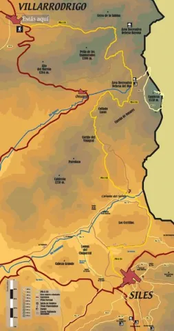
This one that we take care of, runs along the dirt track that leaves to the right of the ceramic panel and, little by little, is gaining height until we reach the Fountain of the Sabina or the Noguerón; from here, we will continue along this same track until we reach a firewall, where we will see the arrow that marks a detour and the path by which we must continue.
This zigzaguea path between pines and madroños, gently ascending until we link to the middle track, we will turn a few meters to the left and when we get back to the firewall we will see on a stone wall the continuation of this path. This stretch, with a similar route to the previous one, will take us to the top track, again by the firewall, where we will have a rewarding view of the Puntal.

On this track we will walk about 100 meters and see a stone that marks the continuation of the path, already softer, until we reach a mold where we can rest. If we move along the track a few meters we will see a splendid view of the Morles River Valley, the village of La Hueta and the hill of Peñalta.
Then our path will come down gently, until we reach the sign that indicates the ascension to the Hole Stone. If we decide to go up to it, we will have to take certain precautions, as the path is narrow and may be dangerous.
We will continue to descend until we reach the Fresnedilla and then we will walk along sections of path and lane alternatively until we reach the old schools of this village. We will cross the road and through a narrow path that runs between rocks and oaks we will get back to the road where we will walk in a banana way until we reach the starting point: the Peña del Olivar.

Breve descripción

La Peña del Olivar is a good place for leisure and rest, and from here several hiking routes start.

Latitud
38.4522
Longitud
-2.6578
Distrito
Municipio
Ubicación en el mapa
POINT (-2.6578 38.4522)
imagen
Image
Ruta%20siles-Villarrodrigo.jpeg
Imagen principal
Activado
imagen
Image
Ruta%20siles-Villarrodrigo1.jpeg
Imagen principal
Desactivado
7 h 30 min

Nature

icon-intereses-naturaleza

Friends

icon-intereses-amigos

Adventure

icon-intereses-aventura

Culture

icon-intereses-cultura

Sport

icon-intereses-deporte

Eco-friendly

icon-intereses-eco-friendly

For couples

icon-intereses-en-pareja

Family

icon-intereses-familia

Gastronomy

icon-intereses-gastronomia

Municipality

icon-intereses-municipio

Low-cost tourism

icon-intereses-turismo-low-cost

Solo travel

icon-intereses-viajar-solo
Medium
Document
Document
Document
Ruta siles-Villarrodrigo
26,4 km
1350m
All year round
Desactivado

Area R. de la Peña del Olivar. The route starts to the right of the start panel.

Route Waterfalls of Hueta

Submitted by brandcode_deweloper on
Id
5931004
Descripción larga

From Siles we take the national road A-310 direction to the Gate of Segura, as we cross the Emilio del Arroyo bridge river of the Molinos, a lane to the villages of Puente Onda and La Hueta is left; this will be the detour we must follow.

We follow the forest track for 2.8 Km towards Puente Honda, once we reach the crossing where you see the Puente Honda Village we will take the detour that comes to the right direction the Hueta.

Next that forest track we will pass through the Mill of the Moors and we will have to go straight for 2 Km until we reach the pastry of La Hueta.

Unrecommended route for children and older persons, as there are large ravines and steep areas that are dangerous.

Breve descripción

In the Natural Park of the Sierra de Segura in the village of La Hueta belonging to the term Orcera.

Latitud
38.336322
Longitud
-2.609489
Distrito
Municipio
Ubicación en el mapa
POINT (-2.609489 38.336322)
imagen
Image
3%20%281%29.jpg
Imagen principal
Activado
imagen
Image
turismoActivo14.jpg
Imagen principal
Desactivado
1 h

Nature

icon-intereses-naturaleza

Friends

icon-intereses-amigos

Adventure

icon-intereses-aventura

Culture

icon-intereses-cultura

Sport

icon-intereses-deporte

Eco-friendly

icon-intereses-eco-friendly

For couples

icon-intereses-en-pareja

Family

icon-intereses-familia

Gastronomy

icon-intereses-gastronomia

Municipality

icon-intereses-municipio

Low-cost tourism

icon-intereses-turismo-low-cost

Solo travel

icon-intereses-viajar-solo
Alta
Ruta Cascadas de la Hueta
1,2 km
172m
All year round
Desactivado

In the village of the Hueta at the beginning of the route we can find a source of drinking water.

La Hueta village.

Coordenadas / Huso 30S
38.336322 / -2.609489
Tramo de asfalto o cemento
 
Tramo de pista o camino forestal
 
Tramo de vía pecuaria
 
Tramo de senda
 

Route Miradores Félix Rodríguez de la Fuente

Submitted by brandcode_deweloper on
Id
5729462
Descripción larga

This route begins at the LINAREJOS VIEWPOINT, from where you can enjoy an excellent panoramic view of much of the Sierra de Cazorla, one of the mountain ranges that make up the Natural Park. The renowned naturalist and great admirer of these landscapes filmed countless scenes very close to this location. During the winter months, you can hear the sound of the water plunging down the nearby Linarejos Stream waterfall. In addition to the “Félix Rodríguez de la Fuente Viewpoints” Route, there are other equally interesting routes nearby that allow visitors to discover more of this magnificent Natural Park, such as Cerrada de Utrero and the Linarejos Viewpoint Route.

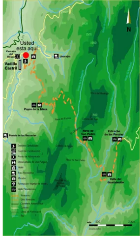
The second VIEWPOINT included on this route is POYOS DE LA MESA, which offers one of the most spectacular panoramic views in the Sierras de Cazorla, Segura y Las Villas Natural Park: the Poyos de la Mesa plateau, which reaches an altitude of 1,635 metres. Should you decide to climb it, you will enjoy breathtaking views of the Guadalquivir Valley, Vadillo-Castril and the El Adelantado Parador, among other places. It is a geological formation highly characteristic of these mountains: a unique high plateau that ends in a steep descending slope. Among the pine forests near this point stands the Pino Abuelo, or Grandfather Pine, one of the oldest trees in the area.

Coordinates: 37.906835,-2.913155

The third VIEWPOINT on the route is NAVA DE SAN PEDRO, where the meadows were once converted into vegetable gardens and cultivated fields. It provides an insight into living conditions at a time when timber was one of the main resources extracted from the mountains and the inhabitants used the relatively scarce open spaces for livestock farming and agriculture. On many occasions, the forest rangers themselves established forest houses in suitable locations such as this one, where vegetable gardens and small-scale livestock farming supplemented both their diet and their income. From this viewpoint, you can enjoy impressive views and learn about the return of the bearded vulture to Andalusia.

The landscape before you was the last Andalusian refuge of an animal as little known as it is spectacular: the bearded vulture. This Iberian vulture disappeared from the mountains you are now looking at in the late 1980s, resulting in its extinction in Andalusia.

Shortly afterwards, work began on the programme to reintroduce the bearded vulture to Andalusia, promoted by the Regional Ministry of the Environment. The species’ most remarkable characteristic is its scavenging diet, as it is the only bird on the planet that feeds almost exclusively on bones. To do so, it has developed an ingenious behaviour from which it takes its name: it drops bones from great heights so that they break against the ground in places known as bone-breaking sites. This allows it to consume large, hard bones. Although the bird is harmless, all the threats faced by bearded vultures are associated with human beings and their activities.

Their populations declined and became locally extinct as a result of direct persecution, collecting, collisions and electrocution involving power lines, and the illegal use of poisoned bait.

Today, they are also affected by disturbance around nesting sites caused by nearby recreational activities such as climbing and paragliding, as well as by reduced food availability and the decline of extensive livestock farming.

To achieve the return of the bearded vulture to Andalusia, feasibility studies were carried out to identify the most suitable areas for the species. A captive-breeding programme was established to provide chicks for reintroduction, together with a release and monitoring plan and a public-awareness programme aimed at informing the sectors involved in its conservation.

The fourth stop has been named the BARRANCO DEL GUADALENTÍN VIEWPOINT, where you can clearly observe the course followed by the river on its way towards the nearby La Bolera Reservoir. Over the centuries, the Guadalentín River has carved an impressive valley through the hard rock, which later narrows into secluded gorges known locally as “cerradas”. From here, the Sierra del Pozo rises majestically, containing some of the highest peaks in the Natural Park, including Pico Cabañas, which stands at over 2,000 metres and dominates the mountain landscape. At the foot of the viewpoint lies the path of the “Félix Rodríguez de la Fuente Viewpoints” Route, which climbs continuously until reaching the end of this magnificent route at the Estrecho de los Perales.

The fifth stop is the ESTRECHO DE LOS PERALES VIEWPOINT, a remarkable gorge distinguished by the beauty of its unusual rock formations. Below, the Valdetrillo Stream tumbles through lively rapids, providing a pleasant natural soundtrack. In this area, you may see agile mouflons and male Iberian ibex climbing the vertical rock faces, or enjoy the majestic flight of a golden eagle, griffon vulture or booted eagle. Behind the viewpoint stands Cerro de los Trancos, which offers views of some of the highest mountains in this protected natural area, including El Cabañas.

“We must do everything within our power; we must fight together, united and tenaciously, so that a vast, round rock does not die: a rock with a heart of iron and basalt, a rock with a skin of water and clouds, a rock whose voice is the singing of birds and the whisper of the breeze, now increasingly overwhelmed by the roar of the machines invented by humankind; a rock travelling through space, carrying the human species and every living animal; a rock that I like to call the blue planet.”

Félix Rodríguez de la Fuente in El Hombre y la Tierra.

Breve descripción

This route is located in Puente de la Cerrada del Utrero. Nearby you will find the INITIO sign of path where it explains that we will travel through the forest track that is headed to the fields of Hernán Perea. It is a free road for road traffic so we must take precautions to walk on a path.

Along the itinerary several viewpoints will help us to interpret the landscape by delights us with the views that these saws offer us.

Among the most striking points are the Cerrada de Utrero and Linarejos, where the waters of the Guadalquivir River have excavated a deep throat, the Poyos de la Mesa, a striking geological formation in which the strong rocky, the Spora de San Pedro, a kárstic planicie surrounded by mountains, The Guadaltir Valley, which leads the waters of this river to the reservoir of La Bolera, and the Strait of Perales, pronounced throat where the rock is the main protagonist of the environment.

You will also pass by the poyos of the Carilong, where he lived the last broken bones of Andalusia. At present this rapture is once again spreading the natural park skies thanks to the reintroduction.

Latitud
37.9202
Longitud
-2.9804
Municipio
Ubicación en el mapa
POINT (-2.9804 37.9202)
imagen
Image
735_img.png
Imagen principal
Activado
imagen
Image
curva.jpg
Imagen principal
Activado
imagen
Image
shutterstock_1060474277.jpg
Imagen principal
Desactivado
4 h 30 min

Nature

icon-intereses-naturaleza

Friends

icon-intereses-amigos

Adventure

icon-intereses-aventura

Culture

icon-intereses-cultura

Sport

icon-intereses-deporte

Eco-friendly

icon-intereses-eco-friendly

For couples

icon-intereses-en-pareja

Family

icon-intereses-familia

Gastronomy

icon-intereses-gastronomia

Municipality

icon-intereses-municipio

Low-cost tourism

icon-intereses-turismo-low-cost

Solo travel

icon-intereses-viajar-solo
Medium
Image
86984fd3-de31-e1f9-58a1-23a33abfa6c7?t=1607016107801
Ruta Miradores Félix Rodríguez de la Fuente
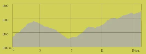
15,2 km
All year round
Desactivado
Image
b16b97bd-2592-e87e-e751-4d81489e51d0?t=1607016265852

Hiking Route Casa Forestal de la Zarza passing through La Iruela and Santo Tomé

Submitted by brandcode_deweloper on
Id
5729300
Descripción larga

Bidirectional
DEDE_

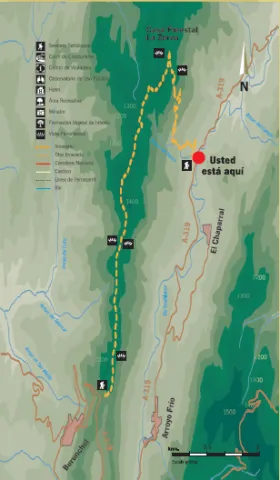
The path goes first through the mountain ridge that allows us to observe on one side the area prepared with olive groves and to the bottom of the Loma and on the other side the Valle del Guadalquivir in the interior of the Natural Park, following the track we will reach the Fountain Forest House of La Zarza. Here we will enjoy a panoramic view of the valley and several summits (El Yelmo, Banderillas and Cabeza del Tejo). Then we go down a path of high slope, old horseshoe road, which passes by the Barranco de la Tuerta, Arroyo del Sauco and the Huertezuelos to end on the road A-319.
Along the way there is a good representation of pine masses, oaks and complaints and even some maples. The lentilery is based on lentils, rosemary, jars and omillos and in the vicinity of the Arroyo more hygrophilic species like willows and chopos. The cornicabra formations in the hills are interesting and in the autumn give an ocre color to the tour.
At the beginning of the route it is common to find leonate vultures and in the descent, in the Barranco and next to the Arroyo it is easy to observe boar, and in the rocky mountain goats. In the rest of the forest mass there are also ungulates: deer and go.


DEDE_

Starting from the Ericas (in the A-319), we ascend through Los Huertezuelos, the Arroyo del Sauco and the Barranco de La Tuerta to reach the forest house of the Fuente de la Zarza. It is an old horseshoe road with strong slopes that in the past joined the Forest Houses of the Sierra. As we gain height we have a panoramic view of the valley and the forest house even of several summits (El Yelmo, Banderillas and Cabeza del Tejo). In the first stretch, we can enjoy the sound of the water and freshness of the Arroyo which in summer represents a true oasis on this slope.
After the forest house of the Fuente de la Zarza, we continue on a road that passes through the mountain crest that allows us to observe on one side the area prepare with olive groves and at the bottom of the Loma, and on the other side the Valle del Guadalquivir in the interior of the Natural Park.
Along the way there is a good representation of pine masses, oaks and complaints and even some maples. The lentilery is based on lentils, rosemary, jars and omillos and in the vicinity of the Arroyo more hygrophilic species like willows and chopos. The cornicabra formations in the hills that in the autumn give an ocre color to the tour are interesting.
Next to the Arroyo it is common to observe boar, and in the rocky mountain goats. In the rest of the forest mass there are also ungulates: deer and gus and in the final part of the tour we can observe leonate vultures.

Breve descripción

The path goes first through the mountain ridge that allows us to observe on one side the area prepared with olive groves and to the bottom of the Loma and on the other side the Valle del Guadalquivir in the interior of the Natural Park, following the track we will reach the Fountain Forest House of La Zarza. Here we will enjoy a panoramic view of the valley and several summits (El Yelmo, Banderillas and Cabeza del Tejo)...

Latitud
37.9242
Longitud
-2.9931
Municipio
Ubicación en el mapa
POINT (-2.9931 37.9242)
imagen
Image
721_img.png
Imagen principal
Activado
imagen
Image
shutterstock_1060474277.jpg
Imagen principal
Desactivado
3 h 30 min

Nature

icon-intereses-naturaleza

Friends

icon-intereses-amigos

Adventure

icon-intereses-aventura

Culture

icon-intereses-cultura

Sport

icon-intereses-deporte

Eco-friendly

icon-intereses-eco-friendly

For couples

icon-intereses-en-pareja

Family

icon-intereses-familia

Gastronomy

icon-intereses-gastronomia

Municipality

icon-intereses-municipio

Low-cost tourism

icon-intereses-turismo-low-cost

Solo travel

icon-intereses-viajar-solo
Alta
Document
Image
8466a76e-af31-72ca-0ad8-aa8cce4ae972?t=1607019009270
Ruta de Senderismo Casa Forestal de la Zarza que discurre por La Iruela y Santo Tomé
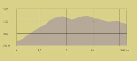
10,78 km
All year round
Desactivado
Image
66400e6a-131b-0b14-cf44-5f1349915746?t=1607019052526
Tramo de asfalto o cemento
 
Tramo de pista o camino forestal
 
Tramo de vía pecuaria
 
Tramo de senda