Saltar al contenido principal

Scenic Drive: Piscifactoría de Borosa - Hornos de Segura

Submitted by brandcode_deweloper on
Id
5713838
Descripción larga
  • Km 0 - Piscifactory and River Borosa River Interpreting Center. In this Centre we will know the importance of water and river ecosystems in the Natural Park, in which emblematic species such as the common trout and the otter stand out.

  • Km 1,7 - Vinagre Tower. This area is one of the most crowded in the Park and is located in a geographically privileged area for its centrality. Here it is essential to know the Park Visitors Center, which has been recently modernized and has various interactive resources. It has a Natural Park Store, toilets, cafe, rest room and children's play area on the outside. Very close to this center is the Botanical Garden, a pleasant place with a wide and careful selection of natural park plants, from small herbaceas to large trees. It is a perfect place to observe and learn to distinguish them or simply to take a pleasant walk between lush vegetation.

  • Km 6.5 - Coto Ríos. This village, on the banks of the Guadalquivir, was built in the 1960s of last century to house families living in scattered villages and cortijos and whose houses were expropriated to create the National Cazorla-Segura Hunting Coto (now the Andaluza de Caza Reserve). It has medical assistance, shops and other services, in addition to several campsites.

  • Km 13.3 - Wild Fauna Park Collado del Almond. In their enclosure they pasture in semi-freedom deer, mountain goats, wos and muflons. You can see them and photograph them by walking a pleasant itinerary with fountains, banks and several viewpoints with splendid views of the Tranco reservoir and the ruins of the castle of Bujaraiza.

  • Km 14 - FRF look. It is one of the milestones of the Route of the same name, dedicated to the mythical naturalist Felix Rodríguez de la Fuente, who from this point of view filmed the famous scenes of the berrea of the deer in the 1970s. In front of it is Mount Bujaraiza, which sometimes, when the reservoir is very full, becomes an island, and is crowned by the ruins of an Arab turret.

  • Km 17.6 - Old-garden controlled area. This place is very nice to eat and rest, except on the dates you are occupied by some camp.

  • Km 19.2 - House of Crafts Los Casares. It is an old Forest House converted into a shop of crafts and products from the Park.

  • Km 26 - Old Control Recreative Area. It is a large and recently built area with magnificent views over the northern part of the Tranco reservoir. It has banks, tables to eat and fountain.

  • Km 28.4 Tranco Dam - This impressive dam, whose height on the Guadalquivir channel is 82 meters, is one of the largest in Spain. In its surroundings there are several restaurants, terraces and water sports facilities, as well as the village that was raised for the workers who built the dam.

  • Km 31.5 - The Parral Recreative Area. It is in the middle of the carrasco pine pinar and has a look-out with good views over the waters of the Tranco reservoir.

  • Km 35.7 - Cñada Morales. When it reaches this village the landscape is opened and no longer exclusively forest, to give way to large humanized areas with olive groves, orchards and scattered cortijos.

  • Km 44.6 - Safe Furnaces. This small town, built on the top of a peñasco, is in the center of the Natural Park. Its monuments, views and irregular alleys of the Arab past, served him the declaration of Artistic Historical Set.

Breve descripción

It is one of the most busy and popular routes of the Natural Reserve, which combines an attractive landscape dominated by the Tranco water reservoir and the opportunity to visit interesting facilities where visitors can enjoy discovering and observing the natural heritage of this protected space. Most of the route follows the winding road A-319.

Do not forget to drive with caution, especially in high season, when there is a greater influx of tourists. You will discover many viewpoints and recreational areas that are good places to stop, but we especially recommend the stops and visits described below. You will find more information about most of these places on this website.

Latitud
37.9502
Longitud
-2.8601
Distrito
Municipio
Ubicación en el mapa
POINT (-2.8601 37.9502)
imagen
Image
piscifactoria%20borosa.jpg
Imagen principal
Activado
imagen
Image
Piscifactoria%20Borosa%2C%20Hornos%20del%20Segura.jpg
Imagen principal
Desactivado
imagen
Image
Piscifactoria%20Borosa%2C%20Hornos%20del%20Segura2.jpg
Imagen principal
Desactivado
Se recomienda al menos 1 día completo.

Nature

icon-intereses-naturaleza

Friends

icon-intereses-amigos

Adventure

icon-intereses-aventura

Culture

icon-intereses-cultura

Sport

icon-intereses-deporte

Eco-friendly

icon-intereses-eco-friendly

For couples

icon-intereses-en-pareja

Family

icon-intereses-familia

Gastronomy

icon-intereses-gastronomia

Municipality

icon-intereses-municipio

Low-cost tourism

icon-intereses-turismo-low-cost

Solo travel

icon-intereses-viajar-solo
Ruta en coche: Piscifactoría de Borosa - Hornos de Segura
45 km
By car, on foot
All year round
Desactivado

Piscifactory del Borosa

Safe Furnaces.

Scenic Drive Hinojares - Quesada (Route Nazarí)

Submitted by brandcode_deweloper on
Id
5713476
Descripción larga

Km 0.0. Departure.In the square of the Constitution of Hinojares (x = 500190; and = 4174475), at the height of the Fountain of the Frogs, we put the CK at 0.0 and we left the village upwards, on the street of the Church, towards the road of Tícar (A-6206).

Km 1.5 Cross of the Tranco de la Zorra (x = 501180; and = 4175910).In the stop we put the CK at 0.0 and turn left.

Km 1,1. Cuenca cross (x = 501825, and = 4175910).We left the main road, to turn right.

Km 3.7. Cuenca (x = 502725; and = 4176830).We park the car in the Consultorio, to visit the Birth of Seven Fuentes and the village; to reach the remains of the fortress and medieval village of the Castellones de Cuenca is complicated, but on the return to the main road, as we pass the last houses of the village, we can see the enclave on the other side of the ravine. When we reach the A-6206, in the stop we put the CK at 0.0 and turn right.

Km 10.2. Belerda Cross (x = 498490; and = 4180130).We're still on the front, direction Quesada. Another option is to turn left to visit The Casillas of Don Pedro and Las Belerdas and return back to this point, where we will follow left; the next point is 0.3 km.

Km 10.5. Entry into the Water Cave (x = 498220; and = 4180260).We turn left; 300 m away are the parking and access to a great open oquedad, crossed by the Arroyo de Tiscar, proposed as a Natural Monument; on leaving to the main road we turn left, to visit the Sanctuary and Castle of Peña Negra. We return to the A-6206, direction Quesada and to the entrance of the Vadillo Road (x = 498015; and = 4180895) we put the CK at 0.0.

Km. 4.8. Port of Tiscar (x = 496675; and = 4182345).We left the car in a space that we found on the right of the road, to go up, taking a walk, to the Atalaya del Infante Don Enrique (13th century) that is enabled as a lookout; behind the tower, the Picón del Rayal (1,834 m.), in the form of a colossal wave; "rayal" was synonymous with "border" in the Reconquista.

Km. 13.5. Quesada (x = 494160; and = 4188735).Here we can visit the Arc of the Saints, the Arc of the Maquita of Utrera, the remains of the Arab Alcazaba, the two churches and the Museum of Rafael Zabaleta.

Breve descripción

Despite the fact that there are natural areas of extraordinary beauty, the historical and cultural interest of this route is its main argument. We will cross a border land between Arabs and Christians that lasted three centuries, until the final take of Granada in 1492. It is essential to understand the culture and uniqueness of the lands of the ancient advance of Cazorla, dependent on the Archbishopric of Toledo, which was created in 1231 and which was abolished by the Cortes of Cadiz in 1811.

Latitud
37.8319
Longitud
-3.0647
Municipio
Ubicación en el mapa
POINT (-3.0647 37.8319)
imagen
Image
654_img.png
Imagen principal
Activado
imagen
Image
Ruta%20en%20coche%20Hinojares%20-%20Quesada%20%28Ruta%20Nazar%C3%AD%29.jpg
Imagen principal
Desactivado

Nature

icon-intereses-naturaleza

Friends

icon-intereses-amigos
Ruta en coche Hinojares - Quesada (Ruta Nazarí)
33 km
By car, on foot
All year round
Desactivado

Scenic Drive del Reservoir Tranco

Submitted by brandcode_deweloper on
Id
5713331
Breve descripción

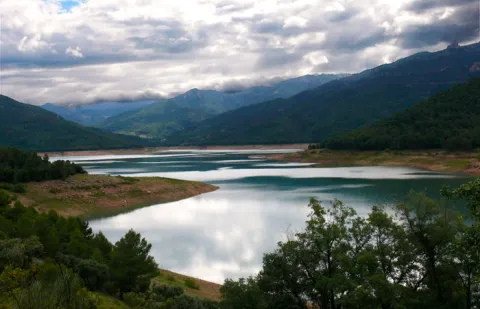
This 43 km route is one of the most classic of the Natural Park. It runs for the most part on the left side of the Tranco reservoir, so the landscape harmoniously combines the platitude of the great water sheet with the rotunity of the great mountains around it, many of them covered by dense pine trees. Not in vain, most of the area is especially protected under the figure of Bujaraiza Reserve Area.

During the first miles, the road runs very close to the Guadalquivir, in the last stretch in which its waters run free before being packed in the Tranco.

The landscape of the reservoir is purely forest, with the predominance of the carrasco pine under whose shade grows a very rich Mediterranean forest.

From the village of Cañada Morales, already near Hornos, the landscape is transformed into a mosaic of mountain olive groves, pine-covered mountains and small villages.

The route has many points to stop at, such as the views and recreational areas of the reservoir and, above all, some of the most relevant public facilities of the Natural Park, such as the Collado del Almond Wildlife Park, the Torre del Vinagre Visitors Center and the Botanical Garden of the same name. It is also worth knowing the villages near the Hornos de Segura.

Latitud
37.9801
Longitud
-2.7902
Distrito
Municipio
Ubicación en el mapa
POINT (-2.7902 37.9801)
imagen
Image
Ruta%20en%20coche%20del%20Embalse%20del%20Tranco%205.jpg
Imagen principal
Activado
imagen
Image
Ruta%20en%20coche%20del%20Embalse%20del%20Tranco.jpg
Imagen principal
Desactivado

Nature

icon-intereses-naturaleza

Friends

icon-intereses-amigos

Adventure

icon-intereses-aventura

Culture

icon-intereses-cultura

Sport

icon-intereses-deporte

Eco-friendly

icon-intereses-eco-friendly

For couples

icon-intereses-en-pareja

Family

icon-intereses-familia

Gastronomy

icon-intereses-gastronomia

Municipality

icon-intereses-municipio

Low-cost tourism

icon-intereses-turismo-low-cost

Solo travel

icon-intereses-viajar-solo
Ruta en coche del Embalse del Tranco
43 km
By car, on foot
All year round
Desactivado

We suggest...

  • The route deserves a full day, without the visit to Hornos.
  • Don't stop quietly in some of the sights and recreational areas. The views are unpayable.
  • It is appropriate to spare no time in El Collado del Almond and Torre del Vinagre, because the resources they offer will love you and will allow you to understand and admire the impressive ecological heritage of the Natural Park.
Tramo de asfalto o cemento
 
Tramo de pista o camino forestal
 
Tramo de vía pecuaria
 
Tramo de senda
 

Scenic Drive de los Miradores

Submitted by brandcode_deweloper on
Id
5713131
Breve descripción

This route runs the first 20 km that has the road A-317 from Hornos to Pontones and Santiago de la Espada. This is a very panoramic section whose seven viewpoints make it an authentic landscape route. All are equipped with parking, banks, stationery and wooden fences. Some also have tables to eat. The viewpoints have attractive ceramic panels, which serve to interpret the landscape and to know some aspects of the natural and cultural heritage of the environment.

The look at La Morra de Los Canalizos (km 31) has tables to eat. A little further we found the crosses to Hornos el Viejo and La Plantera. It is highly advisable to turn around this last village, with its scattered population and large oaks, and even down to the Tranco reservoir, to take a relaxing walk along its margin.

In the impressive Mirabuenos lookout (km 35) the views change quite a lot: from the humanized landscape of the previous lookout, with extensive olive areas and numerous cortijos and villages, we go to the vast panoramic high mountain, where the large forests dominate.

The view of Las Huelguecillas (km 36), which has tables to eat, is on an extensive promontory, and thanks to its situation as a small "peninsula" aerial we enjoy a very wide panoramic in all directions.

The Pradillos lookout (km) is the last and has a special charm for being at 1,340 m of altitude. This section of the A-317 ends when it stops climbing. You'll find a crossing and you'll have two options. If you keep going, you'll go to Pontoons and the birth of the Segura. You will find a livestock landscape, with very clear views. If you choose to turn left, you will enter a more forest landscape. You can complete your route in a circular way by returning to the Hornos de Segura on the roads of La Suma and la Garganta (A-317a).

Latitud
37.9204
Longitud
-2.9803
Distrito
Municipio
Ubicación en el mapa
POINT (-2.9803 37.9204)
imagen
Image
Ruta%20en%20coche%20de%20los%20Miradores2.jpg
Imagen principal
Activado
imagen
Image
Ruta%20en%20coche%20de%20los%20Miradores.png
Imagen principal
Desactivado
imagen
Image
MIR15.jpg
Imagen principal
Desactivado

Nature

icon-intereses-naturaleza

Friends

icon-intereses-amigos

Adventure

icon-intereses-aventura

Culture

icon-intereses-cultura

Sport

icon-intereses-deporte

Eco-friendly

icon-intereses-eco-friendly

For couples

icon-intereses-en-pareja

Family

icon-intereses-familia

Gastronomy

icon-intereses-gastronomia

Municipality

icon-intereses-municipio

Low-cost tourism

icon-intereses-turismo-low-cost

Solo travel

icon-intereses-viajar-solo
Ruta en coche de los Miradores
By car, on foot
All year round
Desactivado

Scenic Drive Cazorla - Cerrada del Utrero - Torre del Vinagre

Submitted by brandcode_deweloper on
Id
5712511
Descripción larga

Km 0. Caraway. The best way to enjoy Cazorla is to get lost in the streets of the old town and to discover some of its wonders, but on this occasion we propose some forced visits: the Plaza de Santa María, the Castle of the Yedra and some churches such as that of the Carmen or San Francisco of Renaissance style.

Km 1.5. The Iruela.Here we propose to stop you again, leave the car by the road and walk up one of the steep streets that lead to the castle that was owned by the Templars. From above you will have a beautiful view of the Guadalquivir depression. Next to the castle you can also visit the Church of Santo Domingo - and know the details of its foundation and history. Back in the car you will enjoy slimmed streets full of flowers that cheer the view.

Km 12. Air Pass lookout.We go up the road that leads us to the Natural Park and to say goodbye to the countryside, nothing better than to stop at this Mirador and enjoy its views. From here we change villages, castles and olive trees to valleys, rivers and mountains.

Km 13. View of the Port of the Doves (1200 m).The landscape changes dramatically. You will find a great panoramic view of the Alto Valle del Guadalquivir, surrounded by beautiful mountains, including the Poyos de la Mesa on the right, unmistakable by its steep cliffs. It is also a good point to observe rapacious birds such as the royal eagle or the leonate vulture.

Km 16. Valley splash.In fact, the Valley Empalme is not a stop but a crossroads. We can turn left and descend to Cold Arroyo, but at this point we will follow the right-hand option following the JF-7092 road that leads us to the Utrero Clock.

Km 19.5. Closed from the Utrel. 3.5 Km from the Empalme del Valle you can reach a bridge over the Guadalquivir River. At this point we have to leave the car. Here begins a circular route of approximately 45 minutes that we will walk. It is a charming walk next to a Guadalquivir that is going to fit in and that later receives the surprise from the air of the stream of Linarejos. Impossible.

Km 23. Valley splash.Back to the road crossing we now continue on the right, following the A-319 road towards Cold Arroyo.

Km 30. Cold Arroyo.At this point in the road we can visit the Ethnographic Museum of Arts and Customs of the Natural Park. Cold Arroyo is also a good place to take something or make some unexpected purchase.

Km 33. Tejina Recreative Area.A stop on the way to rest, relax and eat outdoors if that's your choice.

Km 40. Vinagre Tower.This is certainly a strategic place within the Park because of it some of the routes that will take you to places as famous as the Cerrada de Elias or the Laguna de Valdeazores. At this point there are also a number of facilities that allow you to know the Park. You will find information about this extraordinary enclave in the area "Passeos por el Valle."

Breve descripción

History and nature by the Guadalquivir River are the proposals for this route full of contrasts that leads us to some of the most significant points of the Natural Park of the saws of Cazorla, Segura and the Villas.

The great protagonist is, of course, the Guadalquivir River, which we will see docile in the olive and narrow and noisy countryside in the high parts of the valley where he has been in charge of modeling the magnificent landscapes we will see. You can appreciate the contrast between people full of history and culture, who live together with a natural environment that is invariable and full of life: you will find wild animals, forests that cover the whole landscape, high mountains and water everywhere.

Latitud
37.9143
Longitud
-3.0072
Municipio
Ubicación en el mapa
POINT (-3.0072 37.9143)
imagen
Image
Ruta%20en%20coche%20Cazorla%20-%20Cerrada%20del%20Utrero%20-%20Torre%20del%20Vinagre%205.jpg
Imagen principal
Activado
imagen
Image
Ruta%20en%20coche%20Cazorla%20-%20Cerrada%20del%20Utrero%20-%20Torre%20del%20Vinagre%20%281%29.jpeg
Imagen principal
Desactivado
imagen
Image
5vinagre_vista_bosque_caducifolio.jpg
Imagen principal
Desactivado
1 día

Nature

icon-intereses-naturaleza

Friends

icon-intereses-amigos

Adventure

icon-intereses-aventura

Culture

icon-intereses-cultura

Sport

icon-intereses-deporte

Eco-friendly

icon-intereses-eco-friendly

For couples

icon-intereses-en-pareja

Family

icon-intereses-familia

Gastronomy

icon-intereses-gastronomia

Municipality

icon-intereses-municipio

Low-cost tourism

icon-intereses-turismo-low-cost

Solo travel

icon-intereses-viajar-solo
Ruta en coche Cazorla - Cerrada del Utrero - Torre del Vinagre
40 km (solo ida)
By car, on foot
All year round
Desactivado

Caraway

The Vinagre Tower.

Tramo de asfalto o cemento
 
Tramo de pista o camino forestal
 
Tramo de vía pecuaria
 
Tramo de senda
 

Scenic Drive carretera de La Cumbre

Submitted by brandcode_deweloper on
Id
5712445
Breve descripción

This area is not what suggests its name, but a long and wide range of water between the basins of Guadalquivir and Segura. It is surrounded by the quiet road A-317a, through which you can enjoy a very wooded landscape dominated by larix pine pines, with some points from which a memorable panorama is dominated to the Tranco reservoir, the Las Villas saw and the Banderillas mountain range.

You can take advantage of this stretch of road to close a car circuit with the Miradores Route and the Hornos Grain road. If you want to walk, we recommend the public road that goes east in the direction of the village of Cabeza Gorda passing through the old forest house of the Fuente del Chorro, which passes through dense pine forests.

Latitud
37.9002
Longitud
-2.9701
Distrito
Municipio
Ubicación en el mapa
POINT (-2.9701 37.9002)
imagen
Image
499_img.png
Imagen principal
Activado
imagen
Image
Ruta%20en%20coche%20carretera%20de%20La%20Cumbre.jpg
Imagen principal
Desactivado

Nature

icon-intereses-naturaleza

Friends

icon-intereses-amigos

Adventure

icon-intereses-aventura

Culture

icon-intereses-cultura

Sport

icon-intereses-deporte

Eco-friendly

icon-intereses-eco-friendly

For couples

icon-intereses-en-pareja

Family

icon-intereses-familia

Gastronomy

icon-intereses-gastronomia

Municipality

icon-intereses-municipio

Low-cost tourism

icon-intereses-turismo-low-cost

Solo travel

icon-intereses-viajar-solo
Ruta en coche carretera de La Cumbre
By car, on foot
All year round
Desactivado

Trail Aguacebas Gil and Cobo

Submitted by brandcode_deweloper on
Id
4446105
Descripción larga

From Chilluévar take the Crta de la sierra towards the Embalse de Aguascebas and Charco de La Pringue (This road links with the Crta de Vva from the Archbishop to the Embalse del Tranco). Continue this road for the next 28? km, at that moment we will find the beginning of the path and the pleasant recreational area of the Cueva del Peinero.

Breve descripción

The river of Gil-Cobo, also called Aguascebas de la Cueva del Agua, is born in the Sierra de Las Villas because a cave with that name is nearby. The stream is a tributary of the river Aguascebas Grande, the most important channel of the saw. The road is, in fact, a throat, as it is strongly attached by the Four Villas saw, on the one hand, and The Rasos. In it, the strawberries, the walnuts, the tiles and even the stalks abound.

Latitud
38.2301
Longitud
-2.6603
Municipio
Ubicación en el mapa
POINT (-2.6603 38.2301)
imagen
Image
IMGP8869.jpg
Imagen principal
Activado
imagen
Image
Sendero%20Aguacebas%20Gil%20y%20Cobo.jpg
Imagen principal
Desactivado
10 min

Nature

icon-intereses-naturaleza

Friends

icon-intereses-amigos

Adventure

icon-intereses-aventura

Culture

icon-intereses-cultura

Sport

icon-intereses-deporte

Eco-friendly

icon-intereses-eco-friendly

For couples

icon-intereses-en-pareja

Family

icon-intereses-familia

Gastronomy

icon-intereses-gastronomia

Municipality

icon-intereses-municipio

Low-cost tourism

icon-intereses-turismo-low-cost

Solo travel

icon-intereses-viajar-solo
Baja
Sendero Aguacebas Gil y Cobo
1,9 km
On foot
All year round
Desactivado

Wear clean water and adequate clothing and footwear. Ensure the potability of water from the sources.

We start from the recreational area Aguascebas de Gil Cobo and we will walk the river, which maintains a fresh and abundant flow even in summer, which will find us pleasant surprises in the form of small waterfalls and, above all, the steep ravine known as Cerrada de San Ginés, which forms a unique stage.

Tramo de asfalto o cemento
 
Tramo de pista o camino forestal
 
Tramo de vía pecuaria
 
Tramo de senda
 

Route del Toro Bravo

Submitted by brandcode_deweloper on
Id
2854106
Descripción larga

The tour begins at point 0 of the road J-5010 to the Sanctuary of the Virgin of the Head and Puertollano. In the first three kilometers we move between the family gardens and the irrigations of the terraces of Guadalquivir to pass, at the point of kilometer 4,500, by olive land. From this point, coinciding with the state's stallion stop, the terrain becomes more serrano, first by shrubs and pasture dehesa, gradually passing to high density repopulation pines. At the kilometer point 12,300 we can visit the Visitor Center of the Natural Park Viñas de Peñallana, a place where magnificent recreational farms, known as "Viñas," are located. At the kilometer point 14,200 we take the right deviation on the JH-5002 road, which runs between more or less mixed pineas with lentils, coscojas and jars of great faunistic wealth and cynetic and livestock dedication. At this crossing there are two restaurants, last point for breakfast or a snack in two or three hours. The road has a regular state of conservation.

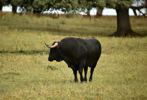
Around the 18th kilometer of the tour, the pineapple disappears, the landscape is dehesa of pastures with oak and cork trees, mainly, and panoramic views of the saw open on both sides. Towards kilometer 21 begins a magnificent adhesado encore in which the bulls of the Finca de los Escoriales, of the iron of D. Germán Gervás, founded in 1959, are pasted. In the km 24,100 we found the mines of Los Escoriales, which was already exploited by the Romans. At the kilometer 24,400 we are at a crossroads and a tentadero. The detour to the left will lead us to the Jandula Embalse. Following to the right we will pass through the Tapicas farms, the Farms of Flores- Albarrán, Navas of Benjamin Sordo or The Alarms of Samuel Flores, the latter since 1928, places where we can discover the bravo bull in its middle, the fences of protection and management, the places of food and abrevadero, along with some protected species or cynetics. From the kilometer point 32,800 you can see magnificent views that must not be lost: to the right, of the Sierra de Ambroz (761 m.), and to the left of the Embalse del Rumblar and the Castle of Burgalimar, in Baños de la Encina. From here on the road continues north, passing through the big house-cortijo of Los Alarcones. The landscape opens to the mountains of Ambroz and Los Calderones, at the northeastern end of the Natural Park of the Sierra de Andújar. At point kilometer 42, and coinciding with the beginning of the National Cote of Selladores- Contadero, we will see areas of small pinars that intermingle with the dehesa and the matorral; later the pinar spots are larger and dense although retaining some copies of alcornoque. The road improves and becomes descending, turning from the house of Selladores to the southeast. The landscape, leaving Selladores- Contadero, changes to a mountain of shrubs dominated by the lentisco jara and natural pastures; thus we arrive at Nava del Sach, in the kilometer 64, where there are catalogued rock paintings, to ascend from here to El Centenillo, a former mining village, in which environment we can see numerous scaffolding of the mines that operated until the 1950s, now converted into a residential core. In this small town we can make a recess to take an appetizer and taste the typical dishes of the place, including hunting meat stew and serrano products. We continue the last part of the route, already on a road of saw in perfect condition of conservation to La Carolina, distant about 16 km, descending from El Centenillo to the Rio Grande, where the pine definitely disappears to follow already on the ground of bushes and pastures and cross the river of the Campana.

Breve descripción

This route connects us to the north-west of the park, where you will find the National Contradero-Sealing Party.

Latitud
38.0394
Longitud
-4.0511
Distrito
Municipio
Ubicación en el mapa
POINT (-4.0511 38.0394)
imagen
Image
ruta-caballo.jpg
Imagen principal
Activado
imagen
Image
shutterstock_1717083154.jpg
Imagen principal
Desactivado
imagen
Image
shutterstock_3420981.jpg
Imagen principal
Desactivado
imagen
Image
shutterstock_1713194008.jpg
Imagen principal
Desactivado
5 h

Nature

icon-intereses-naturaleza

Friends

icon-intereses-amigos

Adventure

icon-intereses-aventura

Culture

icon-intereses-cultura

Sport

icon-intereses-deporte

Eco-friendly

icon-intereses-eco-friendly

For couples

icon-intereses-en-pareja

Family

icon-intereses-familia

Gastronomy

icon-intereses-gastronomia

Municipality

icon-intereses-municipio

Low-cost tourism

icon-intereses-turismo-low-cost

Solo travel

icon-intereses-viajar-solo
Image
6996ab12-e8a9-f353-626d-e1b608c315f1?t=1589486967838
Ruta del Toro Bravo
88 km
All year round
Desactivado

The ideal time to visit from October to the end of April. Set up for 4 hours minimum.

  • Peñallana vineyards
  • The Scoriales, area with cattle of ligia
  • National Contradero-Sealing Cow
  • Mirador Los Alarcornes
  • Mirador Los Pastores
  • El Centenillo, former mining village of Baños de la Encina
  • La Carolina, La Aliseda recreational area

In Andújar (opposite the monument of La Morenita and Carrefour shopping center)

Entrance to La Carolina from the Centenillo road.

Tramo de asfalto o cemento
 
Tramo de pista o camino forestal
 
Tramo de vía pecuaria
 
Tramo de senda
 

Route del Aceite (Segunda jornada: de Las Casillas a Alcalá la Real)

Submitted by brandcode_deweloper on
Id
2681103
Descripción larga

The first part of the day runs along the road from the Vado del Fresno to the Achillos saw. The route leaves the asphalt track before the hill, past the kilometer pillar 16 (km. 9.3). The lantern of earth is attached to a pecuary path, the laundry of Fountain Mateo to Martos. Many crosses and bifurcations come to pass, but none of them offer any doubt as they are marked. At first, constant ups and downs occur, but soon the definitive descent to the Carrizal Sales begins. It is then passed next to the bathroom cortijo (km. 13,9), famous for the sulfurated waters that were flushing there. Later on a mountain known as Encina Hermosa is surrounded, where remains of an important Ibero-Roman enclosure remain.

Shortly before reaching the Vega, the lane that approaches one of the watchtowers that adorn the area is left to the right. Just before the bridge over the San Juan River the itinerary turns left and, along several kilometres, it walks the Vega of the river, along with the route of the Caliphate del Legado Andalusí. At the foot of Castillo de Locubín, the route is diverted (km. 23.1) to continue along the right bank of the river. After a short stretch by road, he takes the direction of El Nacimiento, where a handful of water-nurturing developments all over the valley. After the recreational area, the road fits between the chimallions of the Guadalcoton, and after repeated wadeos the climb to Charilla is undertaken.

Once the city centre has its strength, the route is moved to the left by a lane (km. 34) that borders the slopes of the Loma de San Marcos, ending at the doors of Alcalá la Real. During the two centuries of the Christian siege of the Nazi kingdom, these border lands served as a platform for harassment and skirmishes. Strongholds were raised in the villages, and in their strategic hills a whole chain of watchtowers or simple watchtowers that, as a way of advancing, were watching the enemy's movements. Along the wide-range of the San Juan River, up to 4 towers are counted; although some miraculously whole, they all retain the quiet serenity of those who have seen centuries of history. Anyone who is encouraged to approach his feet will have the opportunity to loot the same horizons, now covered with olive trees.

Latitud
37.4614
Longitud
-3.9222
Distrito
Municipio
Ubicación en el mapa
POINT (-3.9222 37.4614)
imagen
Image
082.jpg
Imagen principal
Activado
imagen
Image
La%20Mota%20Reformada.jpg
Imagen principal
Desactivado
imagen
Image
132.jpg
Imagen principal
Desactivado
imagen
Image
082%20%281%29.jpg
Imagen principal
Desactivado
2 h 30 min

Nature

icon-intereses-naturaleza

Friends

icon-intereses-amigos

Adventure

icon-intereses-aventura

Culture

icon-intereses-cultura

Sport

icon-intereses-deporte

Eco-friendly

icon-intereses-eco-friendly

For couples

icon-intereses-en-pareja

Family

icon-intereses-familia

Gastronomy

icon-intereses-gastronomia

Municipality

icon-intereses-municipio

Low-cost tourism

icon-intereses-turismo-low-cost

Solo travel

icon-intereses-viajar-solo
Alta
Ruta del Aceite (Segunda jornada: de Las Casillas a Alcalá la Real)
38 km
805m
805m
All year round
Desactivado

The stage, although a little long, is very varied. It has an asphalt ascension, followed by a descent and then comes a practically flat stretch that ends in a strong rise. In times of rain certain difficulties may arise by having to wade the Guadalcoton stream four times.

Route del Aceite (Primera jornada)

Submitted by brandcode_deweloper on
Id
2679156
Descripción larga

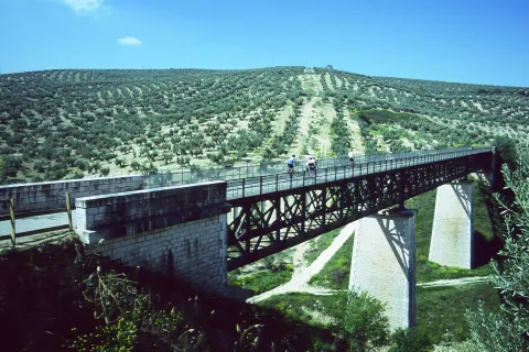
The avenue of Los Olivares then leads to the outskirts of the city, crosses the new circumvalation and follows from the front by an asphalt lane. In the next few miles it will be rolled through the vast olive countryside surrounding Martos. The route, always marked, does not give rise to any doubt. After leaving two other paved lanes on the left and crossing the tracks of the old oil rail, a crossing is reached (km. 5.3). Straight is beginning to descend to the Salado stream, and the impressive metal structure of the old oil train viaduct that saves the first ravine is seen. The route will do it a little later in a fenced way, after having crossed a stretch along the margins of the stream. There is no choice but to face a very steep slope, which is softened just by recrossing the railway platform.

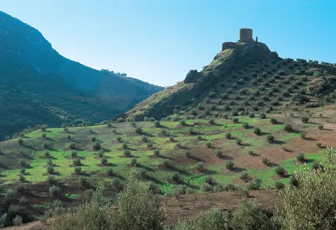
In the next fork is thrown on the left to link, shortly after, with the road to Las Casillas (km. 8.7). For a little more than a kilometer it is circulated through the region that barely supports traffic. In the middle of a hill a dirt lane is taken to the right (km. 10), which after a short rewind descends in the direction of a quarry and immediately to the same foot of the castle Víboras, located on a sharp rocky promontory. To the left the lane leads to the Casillas bordering what in the future will be a reservoir. A wave of soft hills subject to strict olive geometry surrounds Martos. Beyond, these same loins are raised, the ravines are deepened and then the landscape is haunted.

The mountains of the Caracolera, of moderate opulence, and Achillos, of more sharp appearance, truncate the horizon to almost 1,500 meters. The obstinate olive trees roar their tops, while at their feet the oil route runs. The road first savors the sweetness of the jiennese countryside, then it is adventure through the ravine of the Salado and finally stops at the bitter serrano orographic wall.

Breve descripción

The route from Martos, the Plaza de la Cruz del Lloro is a good reference to leave the town without difficulties

Latitud
37.6204
Longitud
-3.9202
Distrito
Municipio
Ubicación en el mapa
POINT (-3.9202 37.6204)
imagen
Image
VIBORAS.jpg
Imagen principal
Activado
imagen
Image
Viaducto%20sobre%20Arroyo%20Salado%20%28Martos%29%20%281%29.jpg
Imagen principal
Desactivado
imagen
Image
Estaci%C3%B3n%20de%20Martos.jpg
Imagen principal
Desactivado
2 h 30 min

Nature

icon-intereses-naturaleza

Friends

icon-intereses-amigos

Adventure

icon-intereses-aventura

Culture

icon-intereses-cultura

Sport

icon-intereses-deporte

Eco-friendly

icon-intereses-eco-friendly

For couples

icon-intereses-en-pareja

Family

icon-intereses-familia

Gastronomy

icon-intereses-gastronomia

Municipality

icon-intereses-municipio

Low-cost tourism

icon-intereses-turismo-low-cost

Solo travel

icon-intereses-viajar-solo
Baja
Ruta del Aceite (Primera jornada)
14 km
280m
280m
All year round
Desactivado

This first stage has no difficulty. We just have to save strength for the ramps at the end. The vado of the Salado stream is reinforced with cement. Any time of the year is good for starting the route, the feast of the olive that is held in Martos on December 8 can be a good pretext.

Tramo de asfalto o cemento
 
Tramo de pista o camino forestal
 
Tramo de vía pecuaria
 
Tramo de senda