Saltar al contenido principal
icon-intereses-aventura

Jabalquinto Palace

Submitted by brandcode_deweloper on
Id
2275703
Descripción
Descripción larga
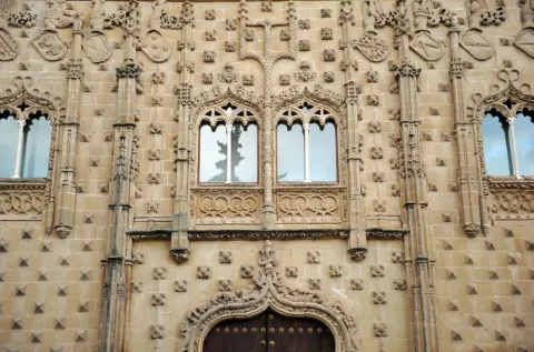
The Palace belongs to the Elizabethan Gothic style (15th century). It was ordered to be built by Juan Alfonso de Benavides, a relative of King Ferdinand the Catholic. His eldest son married Doña Luisa, daughter of the poet Jorge Manrique. This family bond is the fact that links Jorge Manrique with this Baeza space. When the author visited the city he was a guest at the Palace on more than one occasion. A family relationship that “forced” him to participate in the fight against Diego Fernández de Córdoba, Baeza being defeated and imprisoned for a time.
Breve descripción
The palacio de Jabalquinto is a civil architecture building located within the walls of the Spanish city of Baeza, in the province of Jaén. It is one of the most prominent heritage symbols of the town and of the Lordship and later Marquisate of Jabalquinto. It is currently occupied by a headquarters of the International University of Andalusia. It is part of the Renaissance monumental complex of Baeza, which, together with that of Úbeda, was declared a World Heritage Site by UNESCO in 2003. Its façade, decorated with diamond points, nails, pinnacles and shields, is crowned by a Renaissance gallery and its interior features a sober Renaissance patio with two floors of galleries and a monumental Baroque staircase. Until 1720 it was a stately residence.
Ubicación
Código Postal
23440
Latitud
37.991430
Longitud
-3.468810
Dirección
C/ Conde Romanones, 1
Municipio
Ubicación en el mapa
POINT (-3.46881 37.99143)
Tipos de punto de interés
Imágenes carrusel
imagen
Image
shutterstock_1215612649.jpg
Imagen principal
Desactivado
imagen
Image
shutterstock_1214620720.jpg
Imagen principal
Desactivado
imagen
Image
Mon145.jpg
Imagen principal
Desactivado
imagen
Image
Mon110.jpg
Imagen principal
Desactivado
imagen
Image
Mon086.jpg
Imagen principal
Desactivado
imagen
Image
Mon040.jpg
Imagen principal
Desactivado
Imágenes cabecera
imagen
Image
172085.jpg
Imagen principal
Activado
Microsite al que pertenece
Loading map
Preparing points of interest and routes...

Landscapes

Submitted by brandcode_deweloper on
Id
1913945
Descripción
Descripción larga

This diversity is conditioned by its irregular topography from the 400 m of Fuente Álamo to the 1.553 m of the peak of La Martina, as well as by the pronounced dominant climatology, with temos peratures that ascend to the 35 ° C du rante the months of vera no and descend to the -6 ° C in winter.

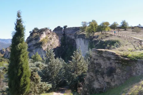
It is important to highlight forms such as Los Tajos, impressive cut and rocky, under which the natural vegetation is served, as a sign of what at one time were the Mediterranean bays of the southern Iberian Peninsula, species such as the oak (Quercus rotundifolia) and the whim (Quercus faginea) dominate the arboreum stratum and others like the peonies (Poeoni broteroi), madreselvas (Lonicera implexa), majuelos (Crataegus monogytoo, or the forest, etc.).

In these enclaves, and developing on the limestone walls, we can find an ende- same plant from the south of the Iberian Peninsula from which only 22 populations of Andalusia have been found and is listed as in danger of extinction, the Saetica Sarcopacnos subsp. Baetica.

As for the fauna that we can find in this ecosystem, from birds such as the vulgar cernicalo (Falco tinnunculus), gratilla (Corvus mone-du / o), piquirroja (Pymhocorax pyrrohocorax), crows (Corvus corax), red roquero (Monticola saxatilis), etc. We can also observe the occasional passage of some perdicular eagle couple (Hieraaetus fasciatus), the migration of the leonate vultures (Gyps fulvus) and other birds found in the forest area such as the boy owl (As / o otus), the real red colirar (Phien / curus phoen / curus), the oropen (On'o / us or / us), etc.

There is also a great diversity of wild mammals in this area that seek refuge in this enclave, although they are species that are difficult to observe, we can detect their presence based on prints and other records, species such as the Garduña (Tuesday foina), Gin (Genettagenetta), badger (Meles meles) and a large number of microfuels that act as the basis of the trophic chain.

It is also interesting to discover the area of Los Llanos, a large plateau where the tree vegetation is absent and where the number of stone or majano accumulations that give the territory a lunar look stand out.

Despite their yerma appearance, the Llanos have high biodiversity and possibilities for observing wildlife. The flora is characterized by the abundance of aromatic species such as lavandas (Lavandula), rosemary (Rosamrinus officinalis), tomi llos (Thymus) etc and fauna, we find a large number of birds linked to this type of large and unequipped ecosystems of arboreal vegetation such as the common cogujada (Calerida cristata), the montesina cogujada (Calenda íeck / oe), the chitovia (Lullulina arbórea), the calandria (Melanocorypha cala), the common (Saxacarus), the (Saguluus párama), the (La páribana (Párárágina), the (La párágina), the (Página), the common (La página), the

Breve descripción

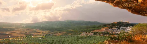
Alcalá la Real is located within the betico territories of the Andes, characterized by a great diversity of landscapes and ecosystems.

Ubicación
Código Postal
23680
Latitud
37.461290
Longitud
-3.922290
Distrito
Municipio
Ubicación en el mapa
POINT (-3.92229 37.46129)
Tipos de punto de interés
Imágenes carrusel
imagen
Image
paisajes.jpg
Imagen principal
Desactivado
Imágenes cabecera
imagen
Image
alcala-naturaleza.jpg
Imagen principal
Activado
Microsite al que pertenece
Loading map
Preparing points of interest and routes...

Rock Oratory of Valdecanales

Submitted by brandcode_deweloper on
Id
4554602
Descripción
Descripción larga

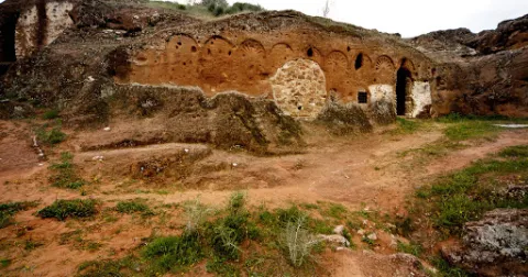
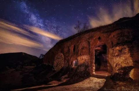
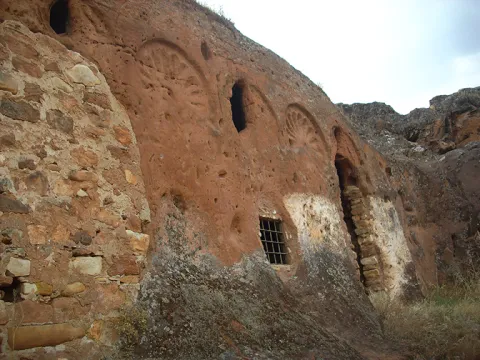
It is a hipogee that consists of three caves excavated in the rock, of which the major has a monumental facade simulating a porch in the form of blind arches, with horseshoe arches and eardrums decorated with palmetas of classical tradition, all carved in the slope of the ground. Inside there is a three-ship chapel with canyon vaults on square pilasters. The other two caves, of simpler resolution, had to serve one as the residence of the monks who lived in the oratory, and the other possibly as Baptistery.

It was declared Good of Cultural Interest in 1970.

Another place of worship or visible cenobium existing in the municipal term Rus, 12 km from the village, is the recently located "Cueva de la Veguilla."

Breve descripción

ThePalrestre oratorio de Valdecanaslocated 6 km from the population, dates from the Visigoda period (7th century) and is the only known example in the southern peninsular. It was discovered by Rafael Vañó Silvestre in 1968. It is located on the hill of the Alcobilla, between Zagahón and near the Giribola swamp, in a natural environment conducive to enjoying both the monument and the landscape. It is a hipigee made up of three caves excavated in the rock.

Telecomunicaciones
Teléfono de contacto
900 202 010
Ubicación
Código Postal
23430
Latitud
38.098310
Longitud
-3.436630
Municipio
Ubicación en el mapa
POINT (-3.43663 38.09831)
Tipos de punto de interés
Imágenes carrusel
imagen
Image
oratorio%20rupestre.jpg
Imagen principal
Desactivado
imagen
Image
oratorio%20rupestre%202.jpg
Imagen principal
Desactivado
Imágenes cabecera
imagen
Image
Oratorio%20rupestre%20de%20Valdecanales.jpg
Imagen principal
Activado
Loading map
Preparing points of interest and routes...

Oppidum by Puente Tablas

Submitted by brandcode_deweloper on
Id
309632
Descripción
Descripción larga
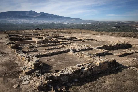
A fortified city that invites you to travel 2,300 years ago and feel the pulse of a civilization
Breve descripción
A fortified city that invites you to travel 2,300 years ago and feel the pulse of a civilization
Telecomunicaciones
Sitio web
www.viajealtiempodelosiberos.com
Teléfono de contacto
670 948 946
Ubicación
Código Postal
23009
Latitud
37.811740
Longitud
-3.745720
Dirección
JV-3012, 15
Distrito
Municipio
Ubicación en el mapa
POINT (-3.74572 37.81174)
Tipos de punto de interés
Imágenes carrusel
imagen
Image
oppidum5.jpg
Imagen principal
Desactivado
Imágenes cabecera
imagen
Image
oppidum2.jpg
Imagen principal
Activado
Horario
From Tuesday to Sunday and holidays: from 9:00 a.m. at 3:00 p.m. | Monday: closed
Loading map
Preparing points of interest and routes...

Andalusian Astronomical Observatory

Submitted by brandcode_deweloper on
Id
2897118
Descripción
Descripción larga

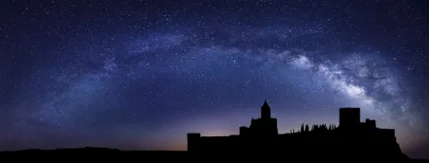
The South Sierra de Jaén, which obtained the Starligth Reserve certificate in 2014, retains the natural lighting and nocturnal conditions of the night sky intact. It is also a space where a commitment has been made to the defence of the quality of the night sky, access to the light of the stars and the different associated values.

The main building, about 70 square meters, houses the multi-purpose room and library, observatory control room, small kitchen, toilet and archive.

To the north of the main building and completely independent, is the observatory itself. The lower floor serves as a storage room for the various instrumentation and accessories of the telescopes and has a small workshop for the repairs.

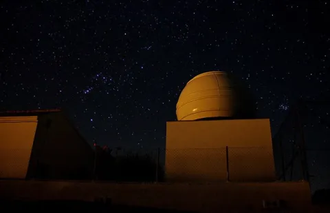
The 4-meter-in-diameter Scope Dome dome, installed on the top, has a Meade S / C LX200-ACF GPS telescope of 0.30 meters of opening at f / 10, in an equatorial fork mount, supported by an independent rigid column.

The whole of the Andalusian Observatory of Astronomy: Dome, telescope as well as its battery of accessories and instrumentation can be operated remotely from anywhere.

On the terrace of the control room there is a weather station specially designed for use in an astronomical observatory and an AllSky automatic camera for meteor detection.

Breve descripción

In the village of La Pedriza, 8 km from Alcalá la Real with an impressive dark sky, the Einstein Society of Astronomy, with the collaboration of the Alcalá la Real City Council, has first-class facilities for astronomical observation and dissemination: the Andaluz Observatory of Astronomy.

Telecomunicaciones
Sitio web
www.astroalcala.es
Teléfono de contacto
661 090 957
Correo electrónico
espartero@astroalcala.es
Ubicación
Código Postal
23688
Latitud
37.414820
Longitud
-3.953560
Distrito
Municipio
Ubicación en el mapa
POINT (-3.95356 37.41482)
Tipos de punto de interés
Imágenes carrusel
imagen
Image
starlight-mota-1536x584.jpg
Imagen principal
Desactivado
imagen
Image
C-2020-F3-Neowise-blog.png
Imagen principal
Desactivado
Imágenes cabecera
imagen
Image
observatorioandaluzastronomia_jaen2.jpg
Imagen principal
Activado
Microsite al que pertenece
Loading map
Preparing points of interest and routes...
Marcas de calidad
Cerrillo Blanco Dynastic Necropolis

Submitted by brandcode_deweloper on
Id
308590
Descripción
Descripción larga

In this necropolis was buried in the 5th century BC the most important impressive sculptural ensemble of all Iberian culture and that can now be seen in the Museum of Jaén.

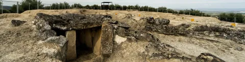
In the archaeological site and in its Visitors Center you will find the keys to understanding this sculptural group and the meaning of death in the Iberian world. Cerrillo Blanco is a funerary tumulum of the Tartesic era (7th century BC) with 24 individual graves in pits and 1 megalytic in which two individuals were buried. Towards the 5th century BC, it was buried in ditches covered with large slabs, an Iberian sculptural set intentionally destroyed. Both by the amount of pieces (approximately 1400 fragments) and by their artistic quality is the most important of Iberian sculpture. This set tells us and tells us the story of how a group of aristocrats became powerful and came to rule the important city of Obulco in Porcra.

The visit to the site is complete with the Porcra Museum which is located in the 15th century Boabdil Tower, in the historic center of the town. This museum has an important collection of Ibero-Roman sculptures. The museum offers guided tours with prior appointment and activity programming throughout the year that you can find on your website:www.museoatocuna.com

Breve descripción

Cerrillo Blanco is one of the most emblematic places of Iberian culture. Walking through this site, you will know an inhumation necropolis dating back to the 7th century BC.

Telecomunicaciones
Teléfono
<p>Oficina de Turismo: de martes a domingo, de 10:00 h. a 13:00 h.<br />
Plaza de Andalucía, 2.&nbsp;</p>
Sitio web
www.viajealtiempodelosiberos.com
Teléfono de contacto
953 545 130
Correo electrónico
oficinaturismo@porcuna.es
Ubicación
Código Postal
23790
Latitud
37.886633
Longitud
-4.179094
Dirección
Carretera Porcuna-Arjonilla, s/n
Distrito
Municipio
Ubicación en el mapa
POINT (-4.179094 37.886633)
Tipos de punto de interés
Imágenes carrusel
imagen
Image
porcuna%20%287%29.jpg
Imagen principal
Desactivado
Imágenes cabecera
imagen
Image
porcuna.jpeg
Imagen principal
Activado
Horario
Site: Tuesday to Sunday 10: 00 - 13: 00 (upon reservation). Porcilla Museum: Tuesday to Sunday 10: 00 - 13: 00.
Loading map
Preparing points of interest and routes...

Cerrillo Salido Necropolis

Submitted by brandcode_deweloper on
Id
4281438
Descripción
Descripción larga

According to the research, it is a necropolis whose extension would surround the entire town, making it one of the most important at the national level.

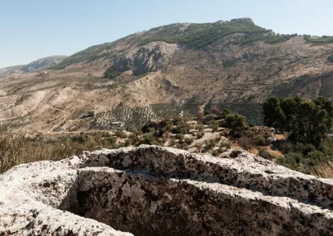
In 1954, the first archaeological excavation was carried out, 22 tombs of which only 7 remained intact. The inspected tombs had an ovoid and excessively elongated form, not keeping a certain orientation.

Next to this visigoda necropolis - just 30 metres - is another Muslim era.

Breve descripción

Located in the municipality of La Guardia, just 500 metres from the urban core, is this Visigoda period site whose tombs are excavated in the rock.

Ubicación
Latitud
37.742568
Longitud
-3.693708
Distrito
Ubicación en el mapa
POINT (-3.693708 37.742568)
Tipos de punto de interés
Imágenes carrusel
imagen
Image
Mon06510%20%281%29.jpg
Imagen principal
Desactivado
imagen
Image
Mon0610%20%281%29.jpg
Imagen principal
Desactivado
imagen
Image
Mon065120%20%281%29.jpg
Imagen principal
Desactivado
Imágenes cabecera
imagen
Image
40.jpg
Imagen principal
Activado
Microsite al que pertenece
Loading map
Preparing points of interest and routes...

Navalta y Navalconejo

Submitted by brandcode_deweloper on
Id
8094809
Descripción
Descripción larga


Location:To the west of the town, in the foothills of the mountain set of the South Sierra.
Distance:7 km.

Medium:Tourism vehicle.

Access route:Taking the road leading to the Hoya del Salobral.

Breve descripción

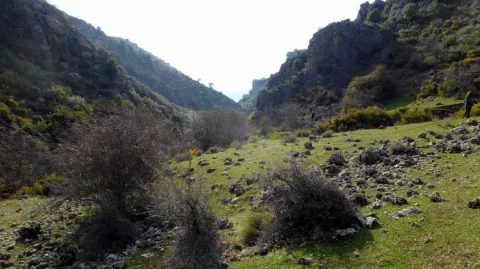
These are fenced valleys surrounded by burning and painting, which are located next to the road leading to Navalcán. They are very visited in the fall by cardo mushroom seekers. The livestock holding (sheep and goats) is very present in this area, with several cortijos in the surroundings dedicated to this work.

Telecomunicaciones
Sitio web
www.noalejo.es/el-municipio/patrimonio-natural.html
Teléfono de contacto
953 306 134
Ubicación
Código Postal
23140
Latitud
37.528500
Longitud
-3.660950
Distrito
Municipio
Ubicación en el mapa
POINT (-3.66095 37.5285)
Tipos de punto de interés
Imágenes cabecera
imagen
Image
Navalta%20y%20Navalconejo..jpg
Imagen principal
Activado
Microsite al que pertenece
Loading map
Preparing points of interest and routes...

Navalcán

Submitted by brandcode_deweloper on
Id
4867827
Descripción
Breve descripción

Depression of karmic origin that belongs to the typical landscape of the Mediterranean mountain. At the same time, we will be able to see a large number of sections, caves, river courses, Mediterranean flora and fauna.

Ubicación
Código Postal
23140
Latitud
37.529021
Longitud
-3.654217
Distrito
Municipio
Ubicación en el mapa
POINT (-3.654217 37.529021)
Tipos de punto de interés
Imágenes carrusel
imagen
Image
navalcan1.jpg
Imagen principal
Desactivado
Imágenes cabecera
imagen
Image
navalcan1-600x450.jpg
Imagen principal
Activado
Microsite al que pertenece
Loading map
Preparing points of interest and routes...

Nava del Espino

Submitted by brandcode_deweloper on
Id
913357
Descripción
Descripción larga

From the Nava del Espino there are roads that lead you to the highest peaks of the Sierra de Cazorla, among which are the Poyos de la Mesa. It is a very recommended route by the views on the Guadalquivir that from this plancie you can reach.

If you stop your way in this place you can enjoy the landscape and if you are at the right time it will be easy to see some go feeding on their meadows.

About 2 km from the Navy following the track you brought, and on the left there is a recreational area next to the Fountain of the Garganta. An ideal place to rest and restore strength.

In Cazorla take the Sierra road (A-319) until the crossing known as the Empalme del Valle. Turn right on the JF-7092 road and after passing the bridge over the Guadalquivir River (4 km from the Empalme) follow the left track (JF-7091). In the km 21 of the road signs is the Nava del Espino.

Breve descripción

By going up the way of the Navas we come to this place which is surprising by its breadth. At 1430 m of altitude you will find high mountain grasslands, some pine-covered areas and an old abandoned forest house that indicate that we have reached the destination. Around you, high hills that seem like we can almost touch with our hands like the Tejo Head, from where it is possible to contemplate the Sierra Nevada summits.

Ubicación
Latitud
37.912893
Longitud
-3.003887
Municipio
Ubicación en el mapa
POINT (-3.003887 37.912893)
Tipos de punto de interés
Imágenes carrusel
imagen
Image
espino%20%281%29.jpg
Imagen principal
Desactivado
Imágenes cabecera
imagen
Image
6942435Master.jpg
Imagen principal
Activado
Loading map
Preparing points of interest and routes...