Saltar al contenido principal
icon-intereses-aventura

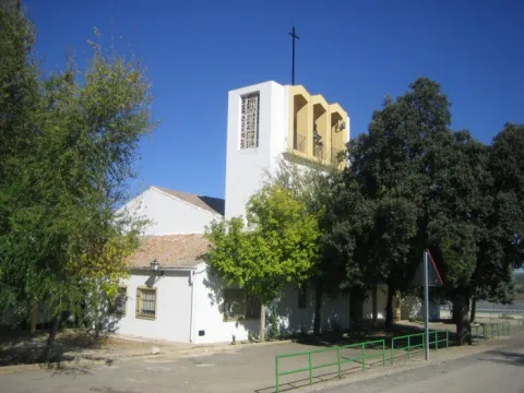
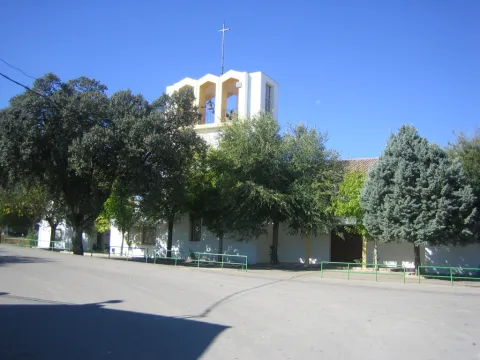
Iglesia Inmaculada Concepción

Submitted by brandcode_deweloper on
Id
4524144
Descripción
Descripción larga
Located in the Barriada Santa Ana, it was built in 1968. It houses images of San Miguel, San José and the Immaculate Conception.
Telecomunicaciones
Sitio web
www.espeluy.es/el-municipio/patrimonio-historico.html
Teléfono de contacto
953 537 161
Ubicación
Código Postal
23628
Latitud
38.03274
Longitud
-3.86195
Dirección
C/ Constitución, 1
Distrito
Municipio
Ubicación en el mapa
POINT (-3.86195 38.03274)
Tipos de punto de interés
Imágenes carrusel
imagen
Image
Iglesia%20Inmaculada%20Concepci%C3%B3n_Espeluy.jpg
Imagen principal
Desactivado
Imágenes cabecera
imagen
Image
inmaculadac.jpg
Imagen principal
Activado
Loading map
Preparing points of interest and routes...

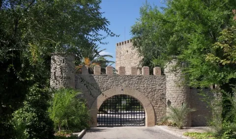
Castillo de Espelúy

Submitted by brandcode_deweloper on
Id
4522991
Descripción
Descripción larga
The castle played an important role at one of the key strategic points controlling the Guadalquivir and Guadalimar rivers. Its origins probably date back to the Caliphate period, although it was destroyed by Ferdinand III in the first third of the 13th century. Once under Christian rule, the castle was rebuilt between the end of that century and the beginning of the next. Its most authentic feature is its magnificent keep, square in plan, which houses two superimposed rooms inside, covered by barrel vaults. It was declared a Site of Cultural Interest in 1985.
Telecomunicaciones
Sitio web
www.espeluy.es/el-municipio/patrimonio-historico.html
Teléfono de contacto
953 537 161
Correo electrónico
espeluy@promojaen.es
Ubicación
Código Postal
23628
Latitud
38.03362
Longitud
-3.86188
Dirección
23628 Espelúy
Distrito
Municipio
Ubicación en el mapa
POINT (-3.86188 38.03362)
Tipos de punto de interés
Imágenes carrusel
imagen
Image
Castillo%20de%20Espel%C3%BAy%202.jpg
Imagen principal
Desactivado
Imágenes cabecera
imagen
Image
castillo_de_espeluy_03_cde.jpg
Imagen principal
Activado
Loading map
Preparing points of interest and routes...

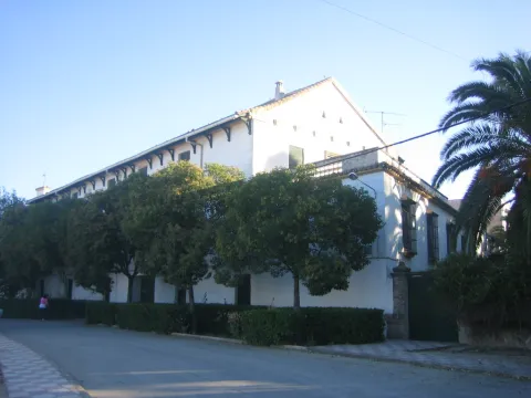
Hacienda del Pilar

Submitted by brandcode_deweloper on
Id
4523531
Descripción
Descripción larga
The Hacienda del Pilar, which takes its name from the image of the Virgin under this title placed on its façade, was built from 1904 onwards as a working farm estate and later remodelled into a private noble residence for receiving dignitaries. Owned by José del Prado y Palacio, former Minister of Public Instruction and Marquis of Rincón de San Ildefonso, it hosted Alfonso XIII during his visit to Jaén in 1916. It was approached through carefully tended English-style gardens with a monumental fountain at their centre and another, in Seville style, to one side. The façade, with two columned galleries — one of them glazed — featured wooden columns and finely worked ironwork, all in a markedly eclectic style. Inside, this eclecticism continued with an element of special interest: a Renaissance courtyard belonging to a palace in Andújar, demolished in the second decade of the century and acquired and transferred to El Pilar by its owner. Nine slender columns, eight arches with cushioned coffering, spandrels, medallions and noble coats of arms were removed from their original building and brought here, along with a fountain with a wide basin, four shells and two bowls, decorated with caryatids. The building also had spacious rooms, a small theatre and a hall with fine furnishings.
Breve descripción
Closed and very difficult to visit. Built from 1904 onwards as a working farm estate and later remodelled into a private noble residence for receiving dignitaries. Its owner was the Marquis of Rincón de San Ildefonso, Don José del Prado y Palacio, Minister of Public Instruction under King Alfonso XIII and one of the great landowners of the area. It is approached through English-style gardens with fountains. It incorporates a Renaissance courtyard taken from a demolished palace in Andújar — that of the Marquis of Puente de la Virgen, formerly located in Andújar's Plaza de España, today Plaza de la Constitución. The building included a small theatre and a hall furnished with walnut furniture.
Telecomunicaciones
Sitio web
www.espeluy.es/el-municipio/patrimonio-historico.html
Correo electrónico
espeluy@promojaen.es
Ubicación
Código Postal
23628
Latitud
38.03192
Longitud
-3.86257
Distrito
Municipio
Ubicación en el mapa
POINT (-3.86257 38.03192)
Imágenes carrusel
imagen
Image
hacienda%20del%20pilar.jpg
Imagen principal
Desactivado
Imágenes cabecera
imagen
Image
hacienda_El_pilar%20%281%29.jpg
Imagen principal
Activado
Loading map
Preparing points of interest and routes...

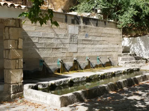
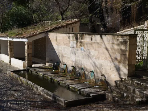
Fountain of the Seven Spouts. Albanchez de Mágina

Submitted by brandcode_deweloper on
Id
1735433
Descripción larga

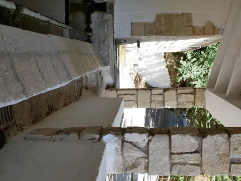
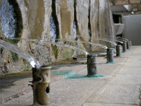
The Fuente de los Siete Caños is a water spring located about 500 metres south of the town of Albanchez de Mágina. This is a clear example of rural architecture, one that combined aesthetics with functionality to pleasing effect. In this case, little explanation is needed, as it is plain to see how the water was put to use for the trough, the washing place, and the irrigation of nearby market gardens and olive groves.

The fountain's construction features a finely finished stone ashlar front. It has seven water spouts, in bronze pipes, which give it a pleasing appearance. It carries a fairly abundant flow, which has never dried up, although in times of drought it tends to reduce somewhat.

The water flow collects in a trough of modest depth, which until recently was used to quench the thirst of the "beasts" that worked the land. Each spout carries a variable flow, with the last one carrying the greatest. Attached to it is a public washing place, featuring two rows for washing clothes and an iron fitting. The water from the washing place flows from the trough through a small stone channel, fitted with a grille to protect anyone passing over it.
The rest area also has street furniture for sitting and enjoying impressive views of the Albanchez river, El Torcal and Bedmar.

This spot also lies along the Route to the Caldera del Tío Lobo, so if you enjoy hiking, don't hesitate to walk it. And once you've completed it, stop, rest and enjoy the surroundings.


Breve descripción

Fountain with seven water spouts, which give it its name. It has a stone-fronted trough and a public washing place, an example of traditional rural architecture linked to the use of water for drinking and for irrigating market gardens, dating back to the 16th century.

Latitud
37.788118
Longitud
-3.466169
Distrito
Ubicación en el mapa
POINT (-3.466169 37.788118)
imagen
Image
p1080490-jpg
Imagen principal
Activado
imagen
Image
p1080488-jpg
Imagen principal
Desactivado
imagen
Image
p1080494-jpg
Imagen principal
Desactivado
imagen
Image
p1022493-jpg
Imagen principal
Desactivado
imagen
Image
dji_20250522110724_0010_d-jpg
Imagen principal
Desactivado
imagen
Image
p1023710-jpg
Imagen principal
Desactivado
imagen
Image
p1070609-jpg
Imagen principal
Desactivado

Friends

icon-intereses-amigos

Nature

icon-intereses-naturaleza

Solo travel

icon-intereses-viajar-solo

Culture

icon-intereses-cultura

Adventure

icon-intereses-aventura

Sport

icon-intereses-deporte

Municipality

icon-intereses-municipio

Low-cost tourism

icon-intereses-turismo-low-cost

Eco-friendly

icon-intereses-eco-friendly
Fuente de los Siete Caños. Albanchez de Mágina
Desactivado

Open 24 hours.

Coordenadas / Huso 30S

30S x=458954 y=4182409

Tramo de asfalto o cemento
 
Tramo de pista o camino forestal
 
Tramo de vía pecuaria
 
Tramo de senda
 

Route of the Castles and Battles

Submitted by brandcode_deweloper on
Id
1477084
Descripción larga

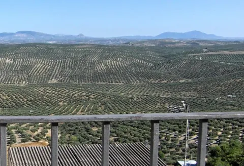
Arjona is included in the Route of the Castles and Battles, an itinerary running through the province of Jaén and part of the provinces of Ciudad Real and Granada. Arjona once had one of the most complex fortification systems in Al-Ándalus, with a triple line of defensive walls which, combined with Arjona's own strategic position, made it an impregnable stronghold. The origin of its wall system is set within the protohistory of the Iberian Peninsula, having been used by the successive cultures that passed through it, all of which left their mark on its structure. Today, part of this vast defensive system survives, along with an Almohad-period cistern located at the heart of the Alcazaba. The Archaeology Room of the Arjona Museum holds remains of weapons used in the Islamic medieval period, notably including arrowheads of a type matching those used at the Battle of Las Navas de Tolosa; also of note, inside the Sanctuary of the Sacred Relics, is a collection of drawings and plans based on the manuscripts of the 17th-century historian Martín Ximena Jurado, showing what Arjona's defensive system looked like at that time.

The visit ticket includes a guide and admission to all monuments, museums and churches, except the Sanctuary of the Sacred Relics; admission to the Sanctuary costs €1, payable at its entrance.

Latitud
37.936503
Longitud
-4.055315
Distrito
Municipio
Ubicación en el mapa
POINT (-4.055315 37.936503)
imagen
Image
vistas.JPG
Imagen principal
Activado

Nature

icon-intereses-naturaleza

Friends

icon-intereses-amigos

Adventure

icon-intereses-aventura

Culture

icon-intereses-cultura

Sport

icon-intereses-deporte

Eco-friendly

icon-intereses-eco-friendly

For couples

icon-intereses-en-pareja

Family

icon-intereses-familia

Gastronomy

icon-intereses-gastronomia

Municipality

icon-intereses-municipio

Low-cost tourism

icon-intereses-turismo-low-cost

Solo travel

icon-intereses-viajar-solo

Ruta de los castillos y batallas

All year round

Desactivado
Coordenadas / Huso 30S

30S x=407265 y=4199295

Tramo de asfalto o cemento
 
Tramo de pista o camino forestal
 
Tramo de vía pecuaria
 
Tramo de senda
 

Almohad Cistern del castillo de Arjona

Submitted by brandcode_deweloper on
Id
5689533
Descripción
Descripción larga

El conjunto fortificado de Arjona, de época medieval, conformaba un complejo e inexpugnable sistema defensivo, formado por tres recintos amurallados: un primer anillo de murallas jalonado por 24 torres que protegía la ciudad, una Alcazaba y el Alcázar. Contaría además con otros elementos defensivos como un foso, que se ha documentado al sur de la fortaleza y un antemuro que crearía una liza o zona de tránsito. 

En las murallas de Arjona se abrirían siete puertas flanqueadas por parejas de torres, excepto la Puerta Nueva que, en realidad, era un portillo. La mayor parte de estos elementos defensivos fueron construidos con mampostería irregular, que puede considerarse sillarejo, unida con argamasa de cal y arena.

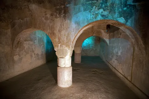
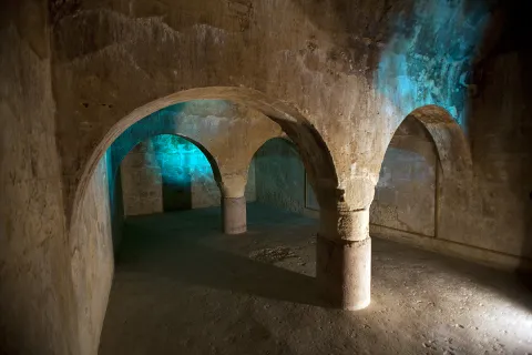
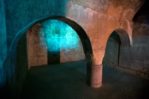
La actual Plaza de Santa María se convirtió durante la Edad Media en la Alcazaba, emplazada en el lugar más elevado de la zona. Un recinto amurallado en el que se levantaban las áreas palatinas que acogían a las clases dirigentes y del estamento militar. Ocupando un extremo de la misma se encontraba el Alcázar, centro político de la ciudad. La Iglesia de Santa María, que preside la mencionada plaza, se identifica con la primitiva mezquita aljama, que se edificaría frente a los palacios islámicos. Junto a ella, se conserva hoy día un gran aljibe medieval, posiblemente almohade, de planta rectangular y cubierto con 3 bóvedas de cañón apoyadas en arcos de medio punto, que descansan sobre columnas romanas, algunas con inscripciones.

En la actualidad permanecen en pie algunos vestigios de sus defensas dispersos entre el caserío, torres y lienzos embutidos en las traseras de las casas, sirviendo de medianeras a viviendas emplazadas en las calles del Reloj, Belén, Sol, etc.  Además, existen fragmentos del antemuro de la Alcazaba en el Paseo de los Mártires, actuando como muro de contención del mismo. También se conservan testimonios de lienzos embutidos en las medianerías que separan el Hospital de San Miguel y la calle Alcázar. 

La ciudad de Arjona ocupa la cumbre y vertientes superiores de un cerro amesetado, desde el que se domina un amplio territorio y las vías de comunicación entre el valle del Guadalquivir y la Campiña. Por su valor estratégico, ha estado ocupada desde la Prehistoria hasta nuestros días. 
En el espacio que hoy ocupa la plaza de santa María se ubicó un asentamiento de las Edades del Cobre y del Bronce. Su ocupación continuará durante el periodo Ibérico, con el establecimiento de un oppidum de medianas proporciones protegido por un sólido recinto amurallado reforzado con bastiones y torres, que rebasaría el espacio de la actual plaza.

Con la llegada de los romanos, el asentamiento se convierte en el municipium de Urgavo, uno de los municipios de mayor importancia a nivel político desde época Augustea y de los primeros que alcanzaron la plenitud de ciudadanía romana. Arjona continuará en poder de Roma hasta el 412 d.n.e., posteriormente, durante el periodo visigodo, el área de ocupación se reduciría a la zona más elevada del cerro.

Tras la conquista musulmana, el linaje de Banu Bayla se asentó en la actual Arjona, que será conocida como Qal´at Aryuna. En estos momentos se reforzaron las murallas y se construye la alcazaba, ocupando lo que fue el oppidum ibérico. Arjona se convirtió en la cabecera de uno de los principales distritos administrativos (Iqlim) en los que fue estructurada la Kura de Yayyan, del que dependerían los asentamientos rurales existentes en su zona de influencia. A finales del siglo IX, el emir Abd Allah mandó fortificar Arjona y Andújar, con el fin de concentrar en estas localidades a la población campesina de su entorno. 

La ciudad de Arjona se consolidaría, al igual que otras poblaciones del Valle del Guadalquivir, entre los siglos XI y XIII, como consecuencia de la inestable situación política en al-Andalus tras la desintegración del Califato Omeya, y por la presión de los ejércitos cristianos. En este periodo se produjo el mayor desarrollo de la ciudad, que se tradujo en un reforzamiento de sus defensas y en la configuración de su entramado urbanístico medieval. En 1232 Muhammad ibn Yusuf ibn Nasr ibn al-Ahmar (Alhamar), originario de Arjona, se proclama sultán en Jaén y seis años después fundará un nuevo reino con capital en Granada.

En 1244, Nuño González sitia Arjona y las autoridades musulmanas pactan la rendición, entregando la ciudad sin resistencia. Pasó a formar parte de las tierras de realengo, constituyéndose como uno de los grandes concejos de Villa y Tierra en los que se estructuraba el reino de Jaén. En el año 1248 le fue concedido el título de Villa por el rey Sancho. En compensación por el apoyo prestado, la ciudad pasó a formar parte del señorío del Condestable de Castilla, Ruy López Dávalos, integrándose posteriormente en las posesiones de D. Álvaro de Luna, quien finalmente la permutaría a la Orden de Calatrava por otras posesiones, que la convirtió en cabeza de Encomienda de la Orden.

La desaparición de la frontera castellano-nazarí dejó obsoletas buena parte de las estructuras que conformaban la cerca murada de Arjona.

LEYENDAS

La yegua del vencedor. Al-lushi poseía una yegua excelente, que llegó a ser tan conocida entre los cristianos de las comarcas vecinas, que el rey castellano, quiso comprarla a cualquier precio. Pero su dueño estaba tan prendado de ella que se la negó. Durante tres noches escuchó una voz en sueños que le decía: “Ve a Arjona y lleva contigo la yegua; pregunta por uno al que llaman Mohammed-ben-Yusuf y en cuanto lo encuentres, véndesela, porque con ella ha de conquistar Jaén y otras ciudades y ha de ser esta conquista muy beneficiosa para las generaciones venideras”. Le contaron que debía tratarse de Alhamar, por lo que partió para Arjona. En la mezquita del castillo le reveló su sueño y acordaron un precio por el animal.  

Un año después, Alhamar tomó el título real en su ciudad natal, Arjona, se apoderó de la ciudad de Jaén y más delante de Córdoba, Sevilla Granada, Málaga, Almería y otras muchas, siendo el fundador de la dinastía y el reino nazarí. 

Breve descripción

The fortified set of Arjona, of medieval times, was a large complex composed of a alcazaba, a alcazar and a large walled exterior enclosure jalonado of towers. Although only structures of the fortress have been preserved, the presence of vestiges of its defenses, towers and canvases, scattered between the house, as well as the almohade, with columns of Roman times, which can be visited by the church. On the 22nd of the Sun Street, the rehabilitation of part of the wall canvas, and of an annexed tower, has made it possible to create a small space for interpretation of the walls of Arjona.
In the Plaza de Santa María, the highest area of the town, the settlements have taken place from Prehistory to today. It was originally a town of the Etudes of Copper and Bronze and then an Iberian oppidum that ended up becoming the Roman Urgavo municipality. After a sharp decline in the population in the Visigodic era, the Muslim occupation brought with it a great development of the city, now called Qal'at Aryuna, head of one of the main administrative districts of the Cora de Jaén. Once conquered by the Christian armies it was made the head of one of the great councils of Villa and Land of the kingdom of Jaén and head of the Order of Calatrava.

Telecomunicaciones
Sitio web
www.arjona.es
Teléfono de contacto
953 523 325
Correo electrónico
ayuntamiento@arjona.es
Ubicación
Código Postal
23760
Latitud
37.937050
Longitud
-4.061320
Distrito
Municipio
Ubicación en el mapa
POINT (-4.06132 37.93705)
Tipos de punto de interés
Imágenes carrusel
imagen
Image
Aljibe%20de%20Arjona.jpg
Imagen principal
Desactivado
imagen
Image
desarrollo-tenflowers_arjona_img_3194-copia%20%281%29.jpg
Imagen principal
Desactivado
imagen
Image
Aljibe%20Almohade.jpg
Imagen principal
Desactivado
Imágenes cabecera
imagen
Image
desarrollo-tenflowers_arjona_img_3190-copia.jpg
Imagen principal
Activado
Horario
Previous date.
Microsite al que pertenece
Loading map
Preparing points of interest and routes...

El Cornicabral Airfield

Submitted by brandcode_deweloper on
Id
1921425
Descripción
Breve descripción

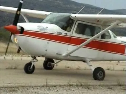
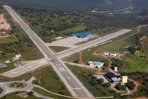
The facilities located in the municipality of Beas de Segura, next to the Natural Park of Cazorla, Segura and the Villas, have two cross-tracks of 1,500 and 700 meters in length, which were already used in 2001 to celebrate the World Air Games. AirSegura is a specialized company that provides the following services from the "El Cornicabral" aerodrome: Air Work:
• Sports flight
• Pilot School - Ultraligeros Flight Center.

Telecomunicaciones
Sitio web
www.airsegura.com
Ubicación
Código Postal
23280
Latitud
38.272410
Longitud
-2.950920
Distrito
Municipio
Ubicación en el mapa
POINT (-2.95092 38.27241)
Imágenes carrusel
imagen
Image
hqdefault.jpg
Imagen principal
Desactivado
imagen
Image
beas-de-segura1.jpg
Imagen principal
Desactivado
imagen
Image
10317712_872585339422486_1628367343718916286_o.jpg
Imagen principal
Desactivado
Imágenes cabecera
imagen
Image
shutterstock_1430600324.jpg
Imagen principal
Activado
Loading map
Preparing points of interest and routes...

La Iruela

Submitted by brandcode_deweloper on
Id
918750
Descripción
Descripción larga

Next to the castle you will find the ruins of the Church of Sto. Silos Sunday. The legend tells that it was built on the place where the Arabs held captive Christians in prison and there was Santo Domingo doing his job. In the building there are traces of the disciples of Vandelvira. It's a must-see for any lover of history.

The Iruela was part of Cazorla until 1370, when Archbishop D. Gome Manrique gave it independence, power and shield. His political and territorial position has allowed him to preserve an important heritage: the Conistory House - a proud building in the Mudejar style of Toledan - and the Church of the Immaculate Conception are part of this legacy.

The population has a core worth visiting. The streets are steep and narrow, with crouched houses and flowers on the balconies. In the center there is a beautiful fountain from which several roads arise to surround the village. From here you can go up to Temple Street on a beautiful stone road accompanied by fig trees and cypresses.

We suggest:

  • About five minutes from La Iruela you will find Burunchel. Come to know the Hermitage of San Julián and the temple of the Holy Spirit among other attractions of this pedany.
  • On August 27, during the summer parties of the village you will see a curious pyrotechnic show, in which the castle is also the protagonist.
Breve descripción

The road that goes up to the saw from Cazorla borders this small, but amazing population. Its best known profile is due to the castle, a legendary fortress that became owned by the Templars and dominates the Guadalquivir Valley. The need to defend itself has given rise to this fortification which, because of its most abrupt aspect, is inexortable. But the Iruela is more attractive.

Ubicación
Latitud
37.920351
Longitud
-2.994140
Municipio
Ubicación en el mapa
POINT (-2.99414 37.920351)
Tipos de punto de interés
Imágenes carrusel
imagen
Image
iruela.jpeg
Imagen principal
Desactivado
Imágenes cabecera
imagen
Image
La-Iruela-Jaen-nuevo-municipio-turistico-de-Andalucia-foto-de-Junta.jpg
Imagen principal
Activado
Loading map
Preparing points of interest and routes...
Marcas de calidad

Paraninfo Antigua Universidad de Baeza

Submitted by brandcode_deweloper on
Id
PUN-0007
Perfil de redes sociales
Descripción
Breve descripción
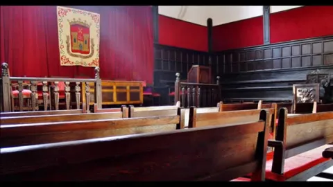
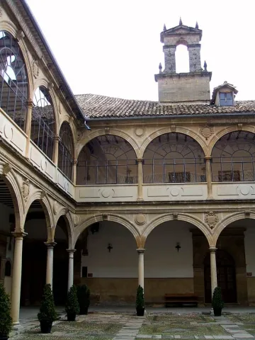
The building of the second half of the 16th century, is structured around a large courtyard with double half-point arches on the dogrous columns and ancestors at the top and in the mirrors and shields. Around are distributed the dependencies, with stone garrison in the lower cloister; among others are the staircase and, above all, the paraninfo, the square floor space, with the gradual and high wooden ceiling, of pairs, knuckles and straps, with a horizontal cloth carved from cassettes and hexagon.
Telecomunicaciones
Sitio web
www.juntadeandalucia.es/cultura/agendaculturaldeandalucia/evento/antigua-universidad-de-baeza
Teléfono de contacto
953 779 522
Correo electrónico
23000817.edu@juntadeandalucia.es
Ubicación
Código Postal
23440
Dirección
San Juan de Ávila, Baeza
Municipio
Tipos de punto de interés
Imágenes carrusel
imagen
Image
Baeza.-Paraninfo-de-la-Antigua-Universidad.jpg
Imagen principal
Desactivado
Imágenes cabecera
imagen
Image
Baeza_-_Antigua_Universidad_08.JPG
Imagen principal
Activado
Microsite al que pertenece

Plaza del Pópulo

Submitted by brandcode_deweloper on
Id
PUN-0006
Perfil de redes sociales
Descripción
Descripción larga
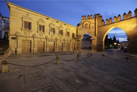
(…) In a serene square, which has an elegant but mutilated and dismantled palace, a graceful altar with rag flowers next to the aristocratic seriousness of a triumphal arch with a warrior air, and a fountain with lions blurred in the stone (…) The Plaza del Populo was one of the most important squares in Baeza, which housed the main public buildings. In this square were located institutions such as the Old Butcher Shops - current headquarters of the courts -, the Civil Court and Public Notary Office or Casa del Pópulo - current Tourist Office -, the Arco de Villalar, the Puerta de Jaén or the Fuente de los Leones, named after the ornamental elements in the shape of a lion through which the water gushed and which apparently come from the Ibero-Roman ruins of Cástulo, which today is in questionable, because for experts in Iberian sculpture its carving in siliceous stone and its formal appearance suggest a much more modern chronology.
Breve descripción
As he does with the Santa María square, Federico García Lorca describes the plaza del Pópulo or Lions square in an admiring and somber way, lamenting the abandonment in which it is found.
Telecomunicaciones
Teléfono de contacto
953 303 572
Ubicación
Código Postal
23001
Dirección
C/ Roldán y Marín, 1
Municipio
Tipos de punto de interés
Imágenes cabecera
imagen
Image
Baeza-plaza-del-pópulo-y-arco
Imagen principal
Desactivado