Saltar al contenido principal
icon-intereses-eco-friendly

Hiking Route Huelga Utrera - Cave of Agua - Poandotello

Submitted by brandcode_deweloper on
Id
5726763
Descripción larga

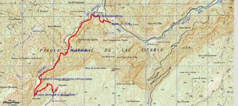
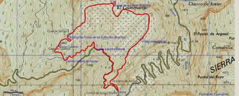
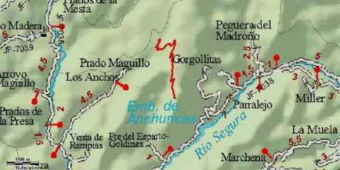
It is a beautiful route that has also been very well conditioned and marked. If it is addressed from bottom to top, the route begins at the detour by the cart that leads to Utrera Strike from the JF-7038, by asphalt track in just 900 meters. The route is described starting from here. From above it starts in Poyotello. At the entrance to this village, on the left, there is an era (steep platform) from which it starts our path.
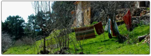
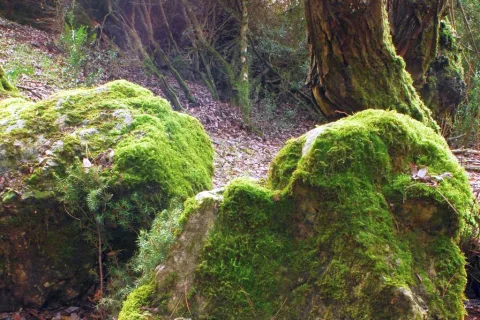
From below, it begins near the quiet village of Huberga Utrera and goes back to the Segura River next to gardens and large nogueras, in the midst of a beautiful landscape of larice pine, of which powerful limestone canteens emerge. Next to the path are the hazelnut, the wild rosewood and the agribusiness, the maple, the sabina and the complaint are frequent, as well as terraces of gardens already abandoned with large nogueras,

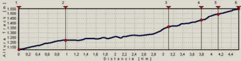
The road is narrow becoming a horseshoe road that continues to ascend along the left bank of the Segura River. The valley is narrow and we walk flanked by impressive vertical walls, baked with numerous caves and abrupt hillsides covered by oak trees. From kilometer 2.4 we find a strong upward slope for 300-400 meters and then descend another 300 meters and we go up to km 4, where we find the signposted detour to the Charco del Humo, to the right, where the river is cleared with force in transparent poches in the midst of a dense vegetation of hazelnuts, willows and mountain olms. In spring we will be able to observe endemic species in flower such as the Cazola violet (Viola cazorlensis) and the grasilla or trapamosque (Pinguicola valisneriifolia)

Displacement to the Charco del Humo: the route is in the valley and we go through it from time to time On our right the valley begins to open, as the Arroyo Patas brings its waters to the Segura, and at this point we can turn to the right just 100 m, pass an old bridge and, under it, contemplate the impressive Charco del Humo, where the river is cleared with force in transparent poches in the midst of a dense vegetation of hazelnuts, willows and mountain olms.

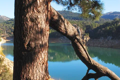
We return through our steps to our route to continue to climb the Segura valley and reach after 4.7 km to the Cueva del Agua, one of the most attractive of this tour, which is a prominent exponent of the Karstico Segureño landscape. From this wide cavity, through which water usually circulates, good views are enjoyed over the Segura canyon.

If we continue the ascending route, leaving the valley behind, and now walking a more demanding path in effort, we can reach the village of Poyotello at the end of the route, at 6.056 km from the beginning, it is located on a natural balcony on the top of the Segura canyon at 1,440 m altitude. From here, already in a typical livestock landscape, you can see a wide range of views of the area.

Breve descripción

It is a beautiful route that has also been very well conditioned and marked. If it is addressed from bottom to top, the route begins at the detour on the road that leads to the Utrera Strike from the JF-7038, by asphalt track in just 900 meters. The route is described starting from here. From above it starts in Poyotello. At the entrance to this village, on the left, there is an era (steep platform) from which it starts our path.

Latitud
38.146376
Longitud
-2.623248
Distrito
Municipio
Ubicación en el mapa
POINT (-2.623248 38.146376)
imagen
Image
696_img.png
Imagen principal
Activado
imagen
Image
shutterstock_1060474277.jpg
Imagen principal
Desactivado
imagen
Image
Cueva%20del%20agua%20Poyotello.jpg
Imagen principal
Desactivado
4 h 10 min (ida y vuelta)

Nature

icon-intereses-naturaleza

Friends

icon-intereses-amigos

Adventure

icon-intereses-aventura

Culture

icon-intereses-cultura

Sport

icon-intereses-deporte

Eco-friendly

icon-intereses-eco-friendly

For couples

icon-intereses-en-pareja

Family

icon-intereses-familia

Gastronomy

icon-intereses-gastronomia

Municipality

icon-intereses-municipio

Low-cost tourism

icon-intereses-turismo-low-cost

Solo travel

icon-intereses-viajar-solo
Medium
1440
Image
4c3a7940-5d6c-ad70-4d2b-c0171cfd8995?t=1607096653856
Image
d5d56efc-49d4-ad76-0cb9-93ece2b5289e?t=1607096672326
HUELGA UTRERA A CUEVA DEL AGUA Y POYOTELLO
6,06 km (solo ida)
569m
154m
1
1
1
3
Horse, on foot
All year round
Desactivado
Image
fbcba4c1-f905-4c9a-0ff4-157b0da2d933?t=1607096662618

The birth of the Segura, La toba and La Morringa

The tour is marked by beacons and directional arrows such as PR-A 195.
Throughout it we find numerous streams, which are suitable places for rest. Special mention is worth the Charco del Humo and the Cueva del Agua, in the middle of the tour, places with special charm, which well deserve a longer stop.

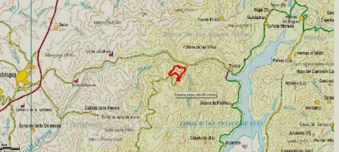
This Path can be realized from two different villages: Utrera Strike (from where it is described here) and Poyotello. To get to Huberga Utrera, for this we must travel the JF-7038 that runs through the Segura River Valley, and just where it flows the Rio Madera in the Segura, we find a detour that leads us to the village of Huberga Utrera.
To reach Poyotello, you have to take the A-317, between Pontones and Santiago de la Sword. We will take a detour to the left, on a narrow and asphalt road (5 km) to reach the village.
It's described from Utrera Strike.

1004

Poyotello
1440
Coordenadas / Huso 30S
30S x = 533012 and = 4222123
Tramo de asfalto o cemento
14.85%
Tramo de pista o camino forestal
85.08%
Tramo de vía pecuaria
0
Tramo de senda
0

Hiking Route Guazalamanco

Submitted by brandcode_deweloper on
Id
5726517
Descripción larga


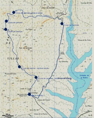
We started the route in El Hornico. We left the car in the parking lot of the Botanical Garden and went to the old Forest House, now a nature classroom, hostel and rural house. Before we reach the first building, on our right we find the starting sign and, behind it, an old cavalry path that ascends through the skirt of the mountain. A wooden beacon, with red band, indicates the km 0 of the route. We will find other wood indications on the itinerary, which belong to other routes, but we will only obey those with a red ring at the top.
At about 950 metres from the starting point, we cross the Sabina Bridge, over the Arroyo de la Venta, which in this section is usually leaked down under the bed edges. A few meters away we reached a forest track and turned left. We follow it until we reach km 2 of our tour, where we will be very attentive because at about 50 meters we take a path (without indicators) that begins to our right. From here we are expected 2.3 km of ascent, in the hardest part of the journey. In the middle of the repulse the path forges. The right-hand option shows old vehicle tracks. Although the two variants take us to the same place, we will choose the one on the left, a softer track. When the slope is crowned, we reach the Collado de los Hercas, a crossing of roads where two jalones indicate the route to follow (the exit further north). We can enjoy a good panorama if we deviate about 300 meters along the road that comes out to our right (it is a jorro, that is, a wooden way of drawing); then we will return to this point and follow the indicators.
About five minutes away we find the ruins of the Forest House of the Prados de Arredondo. By passing the building, the dividing path; we continue on the right, as the beacon tells us. Half a kilometre later we reached the Guazalamanco stream, just where the Cerrada de Navas ends. In this place, if we deviate along the way up, we reach a delicious corner, ideal for a pleasant break. After the refreshment, we continue on the forest track, which we find as we cross the current and, at the height of km 6 of our itinerary, we leave it to follow, on the right, a path that communicates with a path that descends down the hillside. At 800 meters we find the creek again, which we wade twice before we reach the Cascade del Dique. From here we run through the forest track that descends at the same time as the channel, until it is separated from it. 200 meters later we will view the reservoir of the Bolera.
If we have chosen the reduced version (1), down the asphalt slope we will find the first vehicle, with which we can return to El Hornico, where the other one awaits us. If not, we follow the road of land, flat in almost all its way, through the Dehesa del Rincón, until we reach our starting point, 4 Km later.
(1) Reduced option: If it is a group and at least two vehicles are available, one will leave it in the Hornico and the others at 4.1 km following the main ground road, until it reaches a fork, where the left deviation is at cost and asphalt. Logically the Hornico car will have been used to bring the driver or drivers to the starting point. With this option we will save the 4 km most monotonous and dangerous (by the movement of vehicles) of the route.

Breve descripción

We started the route in El Hornico. We left the car in the parking lot of the Botanical Garden and went to the old Forest House, now a nature classroom, hostel and rural house. Before we reach the first building, on our right we find the starting sign and, behind it, an old cavalry path that ascends through the skirt of the mountain. A wooden beacon, with red band, indicates the km 0 of the route. We will find other wood indications on the itinerary, which belong to other routes, but we will only obey those with a red ring at the top.

Latitud
37.804829
Longitud
-2.904941
Municipio
Ubicación en el mapa
POINT (-2.904941 37.804829)
imagen
Image
657_img.png
Imagen principal
Activado
imagen
Image
shutterstock_1060474277.jpg
Imagen principal
Desactivado
5 h 45 min

Nature

icon-intereses-naturaleza

Friends

icon-intereses-amigos

Adventure

icon-intereses-aventura

Culture

icon-intereses-cultura

Sport

icon-intereses-deporte

Eco-friendly

icon-intereses-eco-friendly

For couples

icon-intereses-en-pareja

Family

icon-intereses-familia

Gastronomy

icon-intereses-gastronomia

Municipality

icon-intereses-municipio

Low-cost tourism

icon-intereses-turismo-low-cost

Solo travel

icon-intereses-viajar-solo
Medium
1015
Document
Image
d84fb74f-5399-f2ac-50ba-9dcb6ef13f40?t=1607095645832
Image
518b3045-dfd0-a46c-3753-7bac2931cd70?t=1607095659036
GUAZALAMANCO POR LOS PRADOS DE ARREDONDO
12,2 km
1069m
1310m
1
2
1
3
On foot
All year round
Desactivado
Image
348f8bd0-d32d-dafa-174f-9ad64f73e9bf?t=1607095652283

Packaging of the Bolera and recreational area of the Hoyo de los Pinos or the Bolera

The route is marked with direct arrows and with kilometric posts.

The Botanical Garden of the Hornico is 9 Km from Pozo Alcón and 17 Km from Hinojares. From Pozo Alcón you have to take the A-326, up the Avenida de la Bolera, direction to Castril. By passing the campsite de la Bolera, passing the Km. 7, we take a detour that comes out to our left and that borders the Forest House of la Bolera (the indication to El Hornico is signposted). On an unasphalted road, 2 km later, we take another turn to the left, after passing a bridge, which leads us to the parking lot of the Garden a few meters later. Next to the first building of the nature classroom, is the route's start sign.

1025

Same point

1025
Coordenadas / Huso 30S
30S x = 508368 and = 4184165
Tramo de asfalto o cemento
0.82%
Tramo de pista o camino forestal
47.95%
Tramo de vía pecuaria
0
Tramo de senda
51.23%

Route Félix Rodríguez de la Fuente

Submitted by brandcode_deweloper on
Id
5726239
Descripción larga

The itinerary, which runs along 18 km (every thousand metres) by means of identification. It begins at the Félix lookout, located at the foot of the road of the Tranco A-319, continuing for it towards Arroyo Frio until the intersection with the track leading to the campsiteLlanos de Aranceand that goes along, first, the right bank of the Guadalquivir River and then the tail of the Tranco reservoir. The first half of the route, along the asphalt road, passes through an interesting forest of coniferous: black pines and carrasco, complaints, oaks..., mixed with alffas, strawberries and willows of the river of Guadalquivir, and includes the required visit to the Park of Fauna SilvestreAlmond Necklace. Large mammals, such as deer, mountain goats, muflons and wos, live in semi-freedom this part of the Natural Park

From kilometer 8, past the bridge of the Golondrinas over the Guadalquivir, we travel through a forest track that crosses streams under the refreshing shade of chopos, strawberries and willows, with intrusions of Mediterranean forest, where it will be nothing difficult to meet with deer, boars, squirrels, etc.

Breve descripción

We cannot talk about the Natural Park Sierras de Cazorla, Segura and Las Villas without the extraordinary figure of Professor Felix Rodríguez de la Fuente coming to our attention. Since 2001, the year when this tour was arranged under the advice of the well-known naturalist and writer Joaquín Araujo, the Félix Rodríguez de la Fuente Route has become a reference to reflect the best moments in the TV series "Man and Earth." In 2011, thirty years after the death of Professor Rodríguez de la Fuente in an unfortunate accident, the RFRF has been renewed with new interpretative panels and pointed elements to be visited, without losing detail, in total symbiosis with nature.

Latitud
37.9203
Longitud
-2.9804
Distrito
Municipio
Ubicación en el mapa
POINT (-2.9804 37.9203)
imagen
Image
F%C3%A9lix%20Rodr%C3%ADguez%20de%20la%20Fuente.jpg
Imagen principal
Activado
imagen
Image
F%C3%A9lix%20Rodr%C3%ADguez%20de%20la%20Fuente1.jpg
Imagen principal
Desactivado
2 h en vehículo turismo

Nature

icon-intereses-naturaleza

Friends

icon-intereses-amigos

Adventure

icon-intereses-aventura

Culture

icon-intereses-cultura

Sport

icon-intereses-deporte

Eco-friendly

icon-intereses-eco-friendly

For couples

icon-intereses-en-pareja

Family

icon-intereses-familia

Gastronomy

icon-intereses-gastronomia

Municipality

icon-intereses-municipio

Low-cost tourism

icon-intereses-turismo-low-cost

Solo travel

icon-intereses-viajar-solo
Baja
Ruta Félix Rodríguez de la Fuente
18 km
All year round
Desactivado

Source in the Cortijo de las Animas.

It is advised to remain silent on the forest track to observe wild fauna in its natural habitat.
Forest track crossing restriction: from 18: 00 (winter) and 21: 00 (summer).

The RFRF has five perfectly-equipped viewpoints with interpretative panels of the territory, as well as a natural balcony, which allow a better understanding of the landscape and biological values of the Natural Park Sierras de Cazorla, Segura and Las Villas.

Félix Rodríguez de La Fuente
It is located at 60,500 km of the A-319 autonomous road and offers a beautiful panoramic part of the Sierra de las Banderillas and its 1,993-metre summit, the Tranco reservoir and the small island of Bujaraiza, with the remains of its castle of Muslim origin. At this point, the Man and Earth shooting team filmed the most enchanting scenes of the deer's berrhea in heat.

Mirador Castillo de Bujaraiza
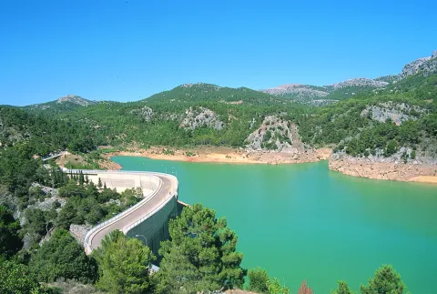
It is located within the Park of Fauna Silvestre, almost two kilometres from the start of the route. It is one of a vestige of the past, when the waters of the reservoir did not flood the fertile vegas of Guadalquivir.

Mirador de las Animas
A few meters from the previous lookout is that of the Animas, which offers spectacular views of the slopes of Piedras Brunas with its characteristic fully vertical flashlights.

Mirabuene Viewer
From here there is a spectacular view of the Guadalquivir before arriving at the reservoir. In addition, we will be able to see, hopefully, the majestic flights of lethargy vultures and some other road eagle.

Natural balcony of Collado del Almond
On the banks of the Tranco reservoir, at the height of kilometer 13.8, we have a unique opportunity to get a panoramic view from the outside of Fauna Silvestre Park. A mile later, it is located in Cortijo de las Animas, where there is a spring water source.

Mirador de Cabeza de la Viña
The huge island ofHead of the vineyardwith its more than a thousand hectares of extension, it seems to be from the waters of the reservoir. This enclave, located at the end of the RFRF, is ideal for the observation of the park's aquatic fauna.

Hiking Route circular Ermita de la Hoz

Submitted by brandcode_deweloper on
Id
5726100
Descripción larga

440 m from the Cave of the Peinero, we find a forest track to the right and in a downhill that runs through pine trees, oaks and madrognals splashed with ferns. Back is the Swarm Stone (1360 m) that belongs to La Albard.
400 m from the start we find a barrier, which cuts the passage to motor vehicles. On your side we can go right through. A few olive trees, mixed with pine trees, show the difficulties of the cultivation of this woody species that is carried out in the area, gaining ground to the forest. Now that agricultural methods are based on high production, it is the forest that gradually gains the ground to the less productive olive groves, in the face of low productivity abandonment.
Later on we find on our right a fenced olive tree next to an irrigation water register; from here we can see a wide panorama of the place where we are, to the south the boat of the Tosero, the peak of Caballo Torraso (1726 m) and the horse of the Albarda, to the east the ravine of Arroyo María, the Poyo de las Andaragasques and the peaks of Las Culebras, Las Grajas and la Veleta. To the north-east, the Rasca del Guijarrón with its surveillance site at the summit, on the other side of the Guadalquivir valley. In this section we find several secondary tracks of entry to olive groves, which we must despise always continuing on the main track.
About 2.4 km from the beginning we arrived at the Houses of the Hermitage of the Hoz, small still inhabited cordijada, of which we must say had a hermitage that gave it name, but today it is completely disappeared. Before we reach them we have left to our left some orchards and fruit. Our route continues not to get into the corrijada, between the first and the second entry to it.
The houses are left to our right to turn left on a track that continues between olive groves, which secondary to the one that has brought us to the houses and is ascending. There are several worse-state olive slopes to it, we will always continue for the main.
After a small roll and a flat, there is a fork to the left about 2.8 km from the start, we follow the front, the track starts to turn left overlooking the Stone of the Be and Loma of the Be, gradually approaching the Arroyo of the Fountain of the Topaero. Later, we arrive at another fork at 3.4 km from the beginning, we will have to go to the front in curve to the left, leaving to our right a stream and the Cortijo of the Straits of the Hoz. In this place there is a water-sink under a oak and numerous fruit.
Later on and after making the route two very pronounced curves, first to the left and then to the right and continuing on the rise, we left to the left of the track the Casa Cuadros, which is surrounded by centenary oak. We are 3.8 km from the beginning. By passing the cortijo there is a fork of roads, we will follow that of the right in an ascending way and do zigzag on the side of the Umbria del Aguilar. We will go through a very lush left curve of vegetation through which a small stream passes and above we will turn, 4.1 km, into a road that comes from the right, to which we join, to continue to the left. This will take us to the asphalt track on which we started the route.
Once on the road, 4.8 km away, we have two options. If we go to the right we can reach, in a little more than 2 km, the Topadero Mirador, with exceptional views, and if we go to the left we return to the starting point in 1.4 km.

Breve descripción

440 m from the Cave of the Peinero, we find a forest track to the right and in a downhill that runs through pinars, oaks and madrognals splashed with ferns. Back is the Swarm Stone (1360 m) that belongs to La Albard.

Latitud
38.173966
Longitud
-2.849114
Ubicación en el mapa
POINT (-2.849114 38.173966)
imagen
Image
671_img.png
Imagen principal
Activado
imagen
Image
shutterstock_1060474277.jpg
Imagen principal
Desactivado
2 h 15 min. Extensión Mirador del Topaero (ida y vuelta): 1 h 15 min

Nature

icon-intereses-naturaleza

Friends

icon-intereses-amigos

Adventure

icon-intereses-aventura

Culture

icon-intereses-cultura

Sport

icon-intereses-deporte

Eco-friendly

icon-intereses-eco-friendly

For couples

icon-intereses-en-pareja

Family

icon-intereses-familia

Gastronomy

icon-intereses-gastronomia

Municipality

icon-intereses-municipio

Low-cost tourism

icon-intereses-turismo-low-cost

Solo travel

icon-intereses-viajar-solo
Medium
994
Image
23c314c1-f51b-8993-c341-b0f9f53dc326?t=1607093266172
Image
3fcf9588-62ff-fee2-b116-0073a71b129f?t=1607093272560
CIRCULAR ERMITA DE LA HOZ
6,2 km al mirador del Topaero / 4,2 km (ida y vuelta)
380m
393m
1
1
1
2
Horse, on foot and bike
All year round
Desactivado
Image
b2b18a9f-d00a-03ac-e534-c31823670321?t=1607093152220

ZAC The Cerezos

In the JH-7155 which is accessed from Mogón or from the oil puddle, in the km. 52.7, where a lane to our right goes down, if we enter from the Agustines Bridge or Oil Charco.

920

Same point

920
Coordenadas / Huso 30S
30S x = 513216 and = 4225128
Tramo de asfalto o cemento
 
Tramo de pista o camino forestal
 
Tramo de vía pecuaria
 
Tramo de senda
 

Hiking Route circular Aguascebas

Submitted by brandcode_deweloper on
Id
5726047
Descripción larga

By accessing from Mogón by the JH-7155, just before crossing the waterfront dam and in the vicinity of the reservoir village we find a forest track to the right in good condition, which is where our tour goes. There is a descriptive panel of the Tranco del Acebo site, which is where the Chorro Gil waterfall is located, to which we will access with this path.
Initially we will visit pine forests with large grasslands, in continuous rise for 1.3 km, leaving on the way several restored cortijos. Once a hill has passed, where there are great clear left, we begin to come down to the Chorro Gil waterfall. In the middle of the descent we hear and see the cascade of Chorro Gil, and when we reach 1.78 km of route we can take a small path to the right that brings us to it, 5 minutes from the track, to then return to this point and continue the path. The Chorrogil Cascade is one of the most spectacular of the park, approaching 100 m of altitude and gives this area a very characteristic microclimate of more northern places, hence the name of the site, Tranco del Acebo.

We continue our route back on the rise until we pass again through another hill 2.5 km from the beginning and again another descent to the Vega del Aguascebas de la Fuente del Tejo. This river runs next to a magnificent gallery forest and large meadows. We must cross the same, 3.3 km from the beginning, by a path following the forest track or by a passing of concrete blocks painted in white. This is the Paso del Manguillo. Again this itinerary begins to rise until it reaches 4.15 km to a road crossing, close to a cortijo that is left to our right, we will continue to the left and almost all our journey will be in descent.

In the km 5.1 we find again another track crossing to the left, we continue to face after having zigzagueado on several occasions. A few ten minutes to the asphalt road JH-7155 we will now have to follow left to reach the beautiful reservoir of Aguascebas. Its dam, on which we will have to pass, is located on the spectacular closure of the Aguascebas Chico. A few meters away, we found the town of the reservoir where the beginning of this itinerary was located.

Breve descripción

By accessing from Mogón by the JH-7155, just before crossing the waterfront dam and in the vicinity of the reservoir village we find a forest track to the right in good condition, which is where our tour goes. There is a descriptive panel of the Tranco del Acebo site, which is where the Chorro Gil waterfall is located, to which we will access with this path.

Latitud
38.045694
Longitud
-2.950503
Municipio
Ubicación en el mapa
POINT (-2.950503 38.045694)
imagen
Image
Ruta%20de%20senderismo%20circular%20Aguascebas.jpg
Imagen principal
Activado
imagen
Image
Ruta%20de%20senderismo%20circular%20Aguascebas1.jpg
Imagen principal
Desactivado
2 h 8 min

Nature

icon-intereses-naturaleza

Friends

icon-intereses-amigos

Adventure

icon-intereses-aventura

Culture

icon-intereses-cultura

Sport

icon-intereses-deporte

Eco-friendly

icon-intereses-eco-friendly

For couples

icon-intereses-en-pareja

Family

icon-intereses-familia

Gastronomy

icon-intereses-gastronomia

Municipality

icon-intereses-municipio

Low-cost tourism

icon-intereses-turismo-low-cost

Solo travel

icon-intereses-viajar-solo
Medium
1015 m
Document
Document
CIRCULAR AGUASCEBAS
221m
234m
1
1
1
2
Horse, on foot and bike
All year round
Desactivado
Image
265a289a-2ef1-6655-bd5d-267d50416a71?t=1607029553302

In the JH-7155 which is accessed from Mogón or from the Oil Charco in the km 18.5, next to the town of Confederación in the reservoir of Aguascebas.

1047 m

Same point

1047 m
Coordenadas / Huso 30S
30S x = 504343 and = 4210886

Hiking Route Cerrada del Utrero and Cascada de Linarejos

Submitted by brandcode_deweloper on
Id
5725805
Breve descripción

The site known as Cerrada del Utroo-Linarejos is an amazing natural work sculpted by the Guadalquivir in the limestone that surrounds it. The path is on foot, and it will allow you to appreciate the sharp rocks and objades created by water over hundreds of thousands of years. It is a charming walk where the labiérnago, the cornicabra, and the willow accompany you to one of the most photographed places in the Park: the "horse tail" or Cascada de Linarejos.

The Guadalquivir made this canyon narrow and deep, leaving some streams - like that of Linarej- hanging on the heights. When this stream is at the throat it forms the spectacular Cascade of Linarejos, which after standing in some pozas joins the Guadalquivir to descend to the valley.

The path is 1.6 km and on its circular route it surrounds the "Peñón del Lanchón" to return to the road in a pleasant walk of about 45 minutes.

In the final part of the road - just before returning to the asphalt - you reach a pine-resinero or black forest (Pinus pinaster) that was used to obtain the resin with which the water used to be made. In these trees you will see the furrows that the resineros opened to allow the exit of this sap.

We suggest:

  • Observe the numerous rupicular birds that nest on the rocky wall in front of our path, as we pass the waterfall of Linarejos. You will see small species, such as the victor, the lone rocher or the white lavender, sharing space with much larger ones like the leonate vulture.
  • Get to know the small town of Vadillo-Castril, where the old Rife sawmill was and today it is the home of two agencies of great importance for the Natural Park: the School of Forest Capataces and the Forest Defense Center.

LOCATION

In Cazorla take the Sierra road (A-319) until the crossing known as the Empalme del Valle. Turn right on the JF-7092 road and just before passing the bridge over the Guadalquivir River (4 km from the Empalme) begins the Cerrada del Utrero path.

Latitud
37.9052
Longitud
-2.9551
Ubicación en el mapa
POINT (-2.9551 37.9052)
imagen
Image
676_img.png
Imagen principal
Activado
imagen
Image
575_image_4.jpg
Imagen principal
Desactivado
imagen
Image
575_image_5.jpg
Imagen principal
Desactivado

Nature

icon-intereses-naturaleza

Friends

icon-intereses-amigos

Adventure

icon-intereses-aventura

Culture

icon-intereses-cultura

Sport

icon-intereses-deporte

Eco-friendly

icon-intereses-eco-friendly

For couples

icon-intereses-en-pareja

Family

icon-intereses-familia

Gastronomy

icon-intereses-gastronomia

Municipality

icon-intereses-municipio

Low-cost tourism

icon-intereses-turismo-low-cost

Solo travel

icon-intereses-viajar-solo
Ruta de senderismo Cerrada del Utrero y Cascada de Linarejos
All year round
Desactivado
Tramo de asfalto o cemento
 
Tramo de pista o camino forestal
 
Tramo de vía pecuaria
 
Tramo de senda
 

Hiking Route Cañada del Saucar - Puntal de la Misa

Submitted by brandcode_deweloper on
Id
5725679
Descripción larga


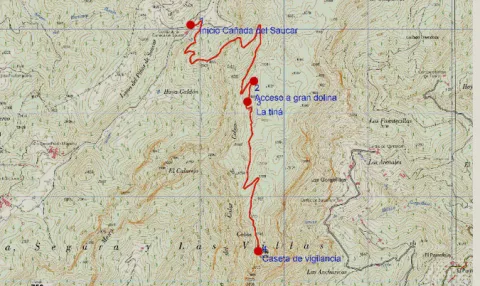
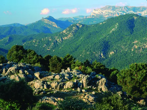
This is one of the most impressive hiking routes in the Segura saw. As we gain height, vegetation is scarce to a piornal austere. Once on the top of the calar, we discover the great and overwhelming atmosphere of the high mountain of Segureña: a huge karmic platform, 5 km long, with meadows where the flocks of Segureña sheep are pasted, broken by dolinas (sodas called "sorbeores" in the region), vaguadillas and sharp rocky.

The remains of stone walls of ancient agricultural terraces remain on the ground, witnesses to the hardness of the old rural life, in which the serrans went up from the nearby villages to sow cereals, taking advantage of the moisture that the soil conserves in a few pits. It is now unthinkable to make such hard daily displacements to start such scarce yields.

From the forest surveillance site of the Puntal de la Misa, and along the east side of the calar, we will dominate unforgettable panoramic over an infinite succession of mountain curtain across the deep valley of the Segura River.

The calar is frequented by flocks of mountain goats and overtaken by the lion vulture. In the cut there are also pilgrims hawks. The whole area is full of boar. It is easy to see the piquiroja chova and the alpine accentor.

Breve descripción

This is one of the most impressive hiking routes in the Segura saw. As we gain height, vegetation is scarce to a piornal austere. Once on the top of the calar, we discover the great and overwhelming atmosphere of the high mountain of Segureña: a huge karmic platform, 5 km long, with meadows where the flocks of Segureña sheep are pasted, broken by dolinas (sodas called "sorbeores" in the region), vaguadillas and sharp rocky.

Latitud
38.22008
Longitud
-2.546613
Distrito
Municipio
Ubicación en el mapa
POINT (-2.546613 38.22008)
imagen
Image
676_img.png
Imagen principal
Activado
imagen
Image
shutterstock_1060474277.jpg
Imagen principal
Desactivado
3 h 22 min (ida y vuelta)

Family

icon-intereses-familia

Friends

icon-intereses-amigos

Nature

icon-intereses-naturaleza

Adventure

icon-intereses-aventura

Solo travel

icon-intereses-viajar-solo

Culture

icon-intereses-cultura

Gastronomy

icon-intereses-gastronomia

Sport

icon-intereses-deporte

Municipality

icon-intereses-municipio

Low-cost tourism

icon-intereses-turismo-low-cost

Eco-friendly

icon-intereses-eco-friendly

For couples

icon-intereses-en-pareja
Baja
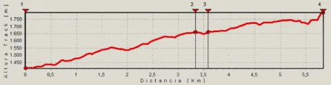
1796
Image
9a64b259-acb7-36ab-9b6b-027116101491?t=1607090586469
Image
c9129abf-a978-ef5c-8f27-4f1eaf341694?t=1607090580344
Cañada del Saucar-Cumbre del Puntal de la Misa
5,9 km (solo ida)
466m
93m
1
1
1
3
Horse, on foot, bike or 4x4
All year round
Desactivado
Image
854c582e-25de-5750-3804-c341e13f63dc?t=1607090573673

The tour is marked PR-A 1196
Water at the source of the Cañada del Saucar, at the beginning of the route.

On the road between Rio Madera and La Toba (JF-7038), take the detour that leads to the villages of Los Anchos and Prado Maguillo, to continue on a good forest track to the cortijos of La Cañada del Saucar, where the beginning is located.

1410

Plot of Surveillance Summit of the Puntal of the Mass

1796
Coordenadas / Huso 30S
30S x = 539687 and = 4230331
Tramo de asfalto o cemento
0
Tramo de pista o camino forestal
0.01
Tramo de vía pecuaria
0
Tramo de senda
0

Hiking Route Campo del Espino a Banderillas

Submitted by brandcode_deweloper on
Id
5725559
Breve descripción

The route begins in the heart of the Fields of Henán Perea, altiplanicie located between the 1600- 1700 m altitude, almost devoid of trees, very rocky and with infinity of formations as a funnel (dolines and simas) that indicate, the difficult winter conditions and the nature of its composition. We are in the largest "sponge" in the park, the limestone absorbs the water, dissolving over the years and forming this landscape so characteristic that many resemble a lunar landscape. Although on certain occasions of the year it may even seem like a desert and dry land, nothing further than reality, under us is the largest underground aquifer of the park.

Latitud
38.01445
Longitud
-2.785396
Distrito
Municipio
Ubicación en el mapa
POINT (-2.785396 38.01445)
imagen
Image
Natu348.jpg
Imagen principal
Activado
imagen
Image
shutterstock_1060474277.jpg
Imagen principal
Desactivado
4 h (ida y vuelta)

Family

icon-intereses-familia

Friends

icon-intereses-amigos

Nature

icon-intereses-naturaleza

Adventure

icon-intereses-aventura

Solo travel

icon-intereses-viajar-solo

Culture

icon-intereses-cultura

Gastronomy

icon-intereses-gastronomia

Sport

icon-intereses-deporte

Municipality

icon-intereses-municipio

Low-cost tourism

icon-intereses-turismo-low-cost

Eco-friendly

icon-intereses-eco-friendly

For couples

icon-intereses-en-pareja
Medium
1985
Image
64b81a4f-9ae6-512e-0b09-b84a0abf5ed5?t=1607089127003
Document
Image
1fcd7c3f-8ff6-aadf-a915-6bdef12934fc?t=1607089134181
CAMPO DEL ESPINO A CUMBRE DEL BANDERILLAS
7,63 km (solo ida)
347m
70m
2
1
2
3
Horse, on foot
All year round
Desactivado
Image
d1090215-2463-6d8e-aa20-982d31281c8b?t=1607089119774

Safe Source

The route begins in the heart of the Fields of Henán Perea, altiplanicie located between the 1600- 1700 m altitude, almost devoid of trees, very rocky and with infinity of formations as a funnel (dolines and simas) that indicate, the difficult winter conditions and the nature of its composition. We are in the largest "sponge" in the park, the limestone absorbs the water, dissolving over the years and forming this landscape so characteristic that many resemble a lunar landscape. Although on certain occasions of the year it may even seem like a desert and dry land, nothing further than reality, under us is the largest underground aquifer of the park.
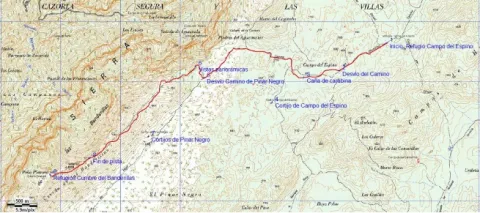
The area with the most abundant fresh pastures in the hottest months and therefore thousands of "segureña" sheep run through this altiplanicie during the period. Our tour has its beginning in a pastoralist shelter that is located in the countryside of Espino, from there we see the Banderillas, the final objective of it. We started in a southwestern direction on the existing forest track, which at first appears a certain linearity. This track is the most passed, especially by the pastors in their movements with the herds.
At 900 m from the start we take a turn to the right, leaving the main track to the left, in this area there are innumerable tracks of vehicles that pass through the canyon, due to the difficult conditions of passage in winter with snow, and in the melting period, Although we find several options of the pull, there is no need to worry because in the end almost all, they lead to the same place. We must maintain the direction now more towards the West. We cross the Carabina Canyon and at 1.7 km from the beginning we leave to our left some ruins, which correspond to the Cortijo del Campo del Espino, to the left of it, usually pastors put salt stones to the sheep flocks (as a food supplement) so it is very common to observe wild fauna (deer, gores, muflons or mountain goats) in that area.
We leave the ruins about 500 m away, to our left, and right ahead there is a larix pine forest, to the right a peeled hill stands out in the landscape, is the Majal de la Carrasca (1812 m), the track passes between the pine and the base of the hill, maintaining the west direction.
At 3.9 km we arrive at a fork, at the front of the road of Pinar Negro, more transited, we continue to the right by a track that is smooth between hills without trees. A few 250 m away we reach a natural balcony over the Aguamulas valley, the Guadalquivir and many other places in the Park. Our route is dimensioned in space and altitude, although from the beginning we were at more than 1700 m, is now when we acquired the feeling of height. And right now, the ascension to the Banderillas (roof of the Segura Region) begins. We continue our track, no options for the desist, now back in the south-west direction.
We soon entered the slopes of the Banderillas, to which are grasped centenary larix pine trees that withstand extreme weather conditions and a predominant bush the boj. Again we are in a very suitable area for wildlife observation, especially if it is sunrise or sunset. In addition, it is very common to meet with a lion's vulture on top of the hillsides, or to overtake us.
Spectacular views, accompany us to the left, altiplano of the Campos de Hernán Perea, Sierra Nevada, La Sagra etc. At 8.8 km from the start, the track ends to continue on a narrow path, which continues to ascend, there are no other options, in just over 800 m will take us to the summit of the Banderillas, where we will find two fire surveillance hubs and probably one of the wider panorama of the Natural Park, as we have to bear in mind that it is the highest altitude we find over the Guadalquivir Valley.

The Campo del Espino is reached by track from Pontones and from Ramblaseca.

1702

Banderillas Summit monitoring houses

1985
Coordenadas / Huso 30S
30S x = 518838 and = 4207440
Tramo de asfalto o cemento
0
Tramo de pista o camino forestal
89.16%
Tramo de vía pecuaria
0
Tramo de senda
10.84%

Hiking Route El Cambrón

Submitted by brandcode_deweloper on
Id
5725500
Descripción larga

This route links the Recreative Area of the Dehesa del Bear with the Cambrón summit, a pétrea mole whose walls rise almost vertical on a pine sea. In the Dehesa del Bear we have a fountain with abundant flow, stone tables, small meadows and beautiful walnuts.

The road gently ascends along a narrow forest track, in the middle of a closed black pine forest with abundant oak and some complaints, from which you enjoy views that go from the valley of the Onsares to Calar del Mundo, valley of the head of the Guadalimar and saw of Alcaraz, in Albacete. In the end it climbs through a path of pastors that opens way between the rocks, to reach the impressive stone platform of the calar, typical carstic landscape of lapiaz with some hills, in which only few isolated black pine trees dare grow.

From the fire surveillance shed there is a superb panoramic from the manchegan plains of Ciudad Real and Albacete to Sierra Nevada. Crossing to the other end of the calar is another house belonging to Castilla-La Mancha. In the area there is plenty of the rocky plane and the piquirred chova, and we can see the flight of the lion vulture and the pilgrim hawk. You can also see flocks of muflons.

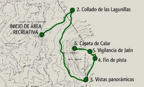
In the Collado de Las Lagunillas, we would continue to the village of El Bellotar, in the province of Albacete. Instead, we turn the track to the right. From here, the track remains without possible loss until it ends at the foot of the calar, which will have to go up a sidewalk.

At the end of the track, we take a path of shepherds to the left that goes up in zig@-@ zag. As we enter the plateau platform, the path loses some definition. We must follow the marks that we will find in stone milestones, pine trees and plates that mark the limits of the Natural Park.

We finally arrived at the Jaén fire site. It is highly recommended to cross the calar to the place in its eastern part, belonging to Castilla-La Mancha, where it will take about 15 'to arrive.

Breve descripción

This route links the Recreative Area of the Dehesa del Bear with the Cambrón summit, a pétrea mole whose walls rise almost vertical on a pine sea. In the Dehesa del Bear we have a fountain with abundant flow, stone tables, small meadows and beautiful walnuts. The road gently ascends along a narrow forest track, in the middle of a closed black pine forest with abundant oak and some complaints, from which you enjoy views that go from the valley of the Onsares to Calar del Mundo, valley of the head of the Guadalimar and saw of Alcaraz, in Albacete.

Latitud
38.461192
Longitud
-2.564754
Distrito
Municipio
Ubicación en el mapa
POINT (-2.564754 38.461192)
imagen
Image
516_img.png
Imagen principal
Activado
imagen
Image
shutterstock_1678062892.jpg
Imagen principal
Desactivado
2 h 45 min

Nature

icon-intereses-naturaleza

Friends

icon-intereses-amigos

Adventure

icon-intereses-aventura

Culture

icon-intereses-cultura

Sport

icon-intereses-deporte

Eco-friendly

icon-intereses-eco-friendly

For couples

icon-intereses-en-pareja

Family

icon-intereses-familia

Gastronomy

icon-intereses-gastronomia

Municipality

icon-intereses-municipio

Low-cost tourism

icon-intereses-turismo-low-cost

Solo travel

icon-intereses-viajar-solo
Medium
1520
Document
Image
1453ec1c-3022-4909-b80c-8abef5f907da?t=1607011772793
Document
Image
a0b0f0b6-e4e7-0990-c254-a53e98f68a96?t=1607011890602
PR-A 173 Cumbre del Cambrón
4,6 km (solo ida)
439m
12m
2
1
2
2
Horse, on foot and bike
All year round
Desactivado
Image
f2ad2904-4380-bff2-9e23-ce2d7ebe8746?t=1607011787369

Dehesa del Bear

The forest track of access to the Dehesa del Bear coincides with part of the PR-A 151 Siles- Villarrodrigo route.

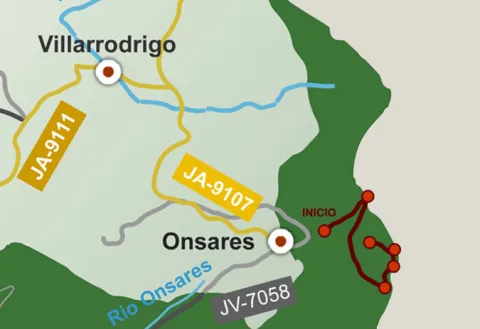
Recreative area of the Bear Dehesa. Your access via the road A-310, from La Puerta de Segura to Siles, direction Siles, past km 12 we take to the left a well-established lane that passes through the village of La Pendolera. After 14.8 km, without being separated by any detour, we reached the Dehesa del Oso.

1125

Navalperal Summit Surveillance Hat

1552
Coordenadas / Huso 30S
30S x = 537973 and = 4257077
Tramo de asfalto o cemento
0
Tramo de pista o camino forestal
82.61%
Tramo de vía pecuaria
0
Tramo de senda
17.39%

Hiking Route Aguascebas de Gil Cobo and subida al Blanquillo

Submitted by brandcode_deweloper on
Id
5714794
Descripción larga

Forest track that starts at km 28 of the JH-1755 (Transversal de las Villas) road, to the right, right next to the river Aguascebas de Gil Cobo, very close to Recreative Area of the same name.

Breve descripción

The wide road enters the San Ginés closed, parallel to the stream. The channel has been capriciously modeled by the action of water, giving rise to unique jumps and small water pods. Some sections are flanked by abrupt rocky brown. On its shores we find an exceptional vegetation with various endemic species, as well as tides, stalks and even some birches, a purely northern and very scarce tree in the Natural Park.

We continue as far as the track forks and follow our left, accompanied by magnificent pinars. The sinuous route of the road allows us a smooth rise to the Collado del Perenoso, where we have a spectacular view of this whole environment. This is the starting place towards the peak of the Blanquillo or Pedro Miguel.

The tour here has plenty of attractive to do, but if we want stronger emotions, we can ascend to this extraordinary summit. We take to our right a narrow path that runs through a soft hill between salgarean pines in its first stretch.

We continue along this path, through a small ledge that diagonally crosses a rocky wall, and with great caution we pass some sections that have some difficulty. We follow the path, passing a stream that descends from the summit, and we reach a small plain, which is named "La Carrasquilla," from where we see the dominant limestone mole, the modesty vegetation of the high mountain and the shaded pine trees that indicate the extreme weather conditions of this place.

From here we see the final section of this route. We will head towards a small hill and from there we follow the rope, where the arrival to the top is more serene. Once at the summit we have before us all the immensity and beauty of these unusual places.

Latitud
38.2201
Longitud
-2.6703
Municipio
Ubicación en el mapa
POINT (-2.6703 38.2201)
imagen
Image
684_SS_07.jpg
Imagen principal
Activado
imagen
Image
667_image_1.jpg
Imagen principal
Desactivado
imagen
Image
Natu017.jpg
Imagen principal
Desactivado

Family

icon-intereses-familia

Friends

icon-intereses-amigos

Nature

icon-intereses-naturaleza

Adventure

icon-intereses-aventura

Solo travel

icon-intereses-viajar-solo

Culture

icon-intereses-cultura

Gastronomy

icon-intereses-gastronomia

Sport

icon-intereses-deporte

Municipality

icon-intereses-municipio

Low-cost tourism

icon-intereses-turismo-low-cost

Eco-friendly

icon-intereses-eco-friendly

For couples

icon-intereses-en-pareja
Ruta de senderismo Aguascebas de Gil Cobo y subida al Blanquillo
On foot
All year round
Desactivado

Once at the top, approach the pinar that is observed to the north, known as Black Pinar. It is a forest made up of centenary and unique examples of salgarean or laritian pine trees (Pinus nigra ssp. salzmanii), in which there is a small fountain with its wooden tornachs, which the mountain-flocks use as a watershed.

The possibility to make the descent through the rope in a southwestern direction towards the hill of White Water and descent through the vaguada, towards the main track of the Cerrada San Gines.

Tramo de asfalto o cemento
 
Tramo de pista o camino forestal
 
Tramo de vía pecuaria
 
Tramo de senda