Saltar al contenido principal
icon-intereses-cultura

Bullring of Baeza

Submitted by brandcode_deweloper on
Id
1563321
Descripción
Descripción larga

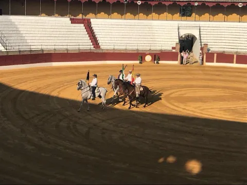
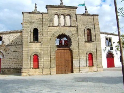
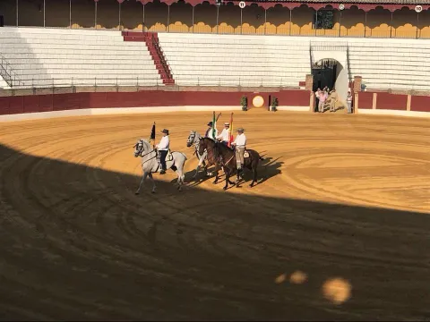
This square was built in 1892 using neo-Mudejarianism as a style, both inside and on the outer gates, where horseshoe arches predominate. Some of the materials were reused from some churches and property abandoned after the deamortization, as well as from the remains of the first Plaza de Toros.

It consists of three floors: laying, stand, palches and second stand. It also has two cavalries, corrals for the cattle of ligia, covered poultry to verify the section and corraleta, six chickers, bulldozers room, chapel, nursing, administration, pallet of drag, butcher and ticket office.

The square offers the possibility of organizing events for incentives and congresses, concerts and shows.

Breve descripción

The bullring of Baeza is an example of 19th century architecture, with a clear eclectic language.

Telecomunicaciones
Sitio web
www.baeza.net/servicios_municipales/oficina-de-turismo/
Teléfono de contacto
953 740 150
Correo electrónico
turismo@baeza.net
Ubicación
Código Postal
23440
Latitud
37.993910
Longitud
-3.460650
Dirección
C/ Diego de Hoces, 2
Municipio
Ubicación en el mapa
POINT (-3.46065 37.99391)
Tipos de punto de interés
Imágenes carrusel
imagen
Image
Baeza2.jpg
Imagen principal
Desactivado
imagen
Image
Plaza-toros-baeza-e1525518123140.jpg
Imagen principal
Desactivado
Imágenes cabecera
imagen
Image
Baeza2%20%284%29.jpg
Imagen principal
Activado
Horario
Thursday to Sunday: 10: 30 - 13: 30. Spring and autumn: 16: 30 - 19: 30. Summer: 18: 00 - 21: 00. Winter: 16: 00 - 18: 30. Guided tour on request.
Microsite al que pertenece
Loading map
Preparing points of interest and routes...

Square de Santa María

Submitted by brandcode_deweloper on
Id
918485
Descripción
Descripción larga

The Church of Santa Maria was the most important monument of the advance of Cazorla. As a Renaissance, his inspiration is attributed to Andrew of Vandelvira or one of his disciples. It is built on the Cerezuelo River, taking advantage of the vault that covers the river and crosses the entire Plaza.

It is not the only unique building we find there: the House of the Clérigos, the Thematic Center of Threatened Species, the old Conistorial Houses (in an alley above the square) or the Fountain of the Chain (built in 1605) are some of the many visits we can make here.

In the square we also find nice restaurants that offer a great sample of local cuisine. To enjoy these dishes in the quiet dusk is one more reason to often go to this suggestive square.

We suggest:

  • Visit the ruins of Santa Maria, know its history and its curious construction. You can order information from the tourist office (953 71 01 02).
  • Up by the river Cerezuelo, passing the ruins of Santa María in the direction of the castle of La Yedra, and walking along one of the small routes that begin in this area. An information panel will help you to better know this area of the city.

In Cazorla, we leave the Plaza de la Constitución, in the center of the village. From here follow Doctor Muñoz Street to La Corredera Square. At the end of this, we turn right and immediately left, following the signs to the Castle of La Yedra. After passing by the balcony of Zabaleta and crossing the street José Salcedo Cano - a narrow and steep street with numerous pots in its balconies - we reached the Plaza de Santa María.

Breve descripción

Reaching the Old Square or Santa Maria Square through the old town of Cazorla is a surprise for the walker. The open space with the high slopes of the Peña de los Halcones, the Gilillo peak or the castle of La Yedra make it difficult for you to see what you have at your height. But at your height there is a beautiful square full of history and charm, where the ruins of the Church of Santa Maria demand the attention of the many travelers who come to this place.

Ubicación
Latitud
37.912893
Longitud
-3.003887
Municipio
Ubicación en el mapa
POINT (-3.003887 37.912893)
Tipos de punto de interés
Imágenes carrusel
imagen
Image
6%20%282%29.jpg
Imagen principal
Desactivado
Imágenes cabecera
imagen
Image
7%20%281%29%20%281%29.jpg
Imagen principal
Activado
Loading map
Preparing points of interest and routes...
Marcas de calidad

Santa María Square

Submitted by brandcode_deweloper on
Id
5742287
Descripción
Descripción larga
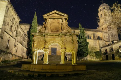
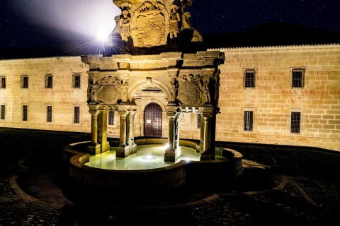
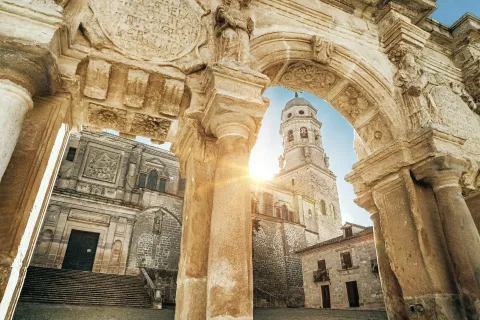
Machado tells us that his hobbies were walking and reading. José Chamorro, in his work Antonio Machado in the Province of Jaén, tries to reconstruct the poet's itinerary on his walks: "the streets of Santo Domingo, San Pablo, San Andrés, Puerta de Úbeda, Arco del Barbudo, etc.; highlighting "precincts as artistic and Spanish as the Plaza de la Catedral with its monumental fountain, erected with the majesty of a triumphal arch, a plaza as solemn as lonely with the moss of the old walls and the little green grass between the flagstones and stones of the pavement.” Among his wanderings through the historic center of Baeza, Machado has left some stanzas dedicated to this space, such as the famous San Cristobalón poem. NOTES III Through a window, the owl came in in the cathedral. San Cristobalón He wanted to scare her, seeing that he was drinking of the oil candle from Santa María. The Virgin spoke: -Let her drink, San Cristobalón. The Cathedral of Baeza, a Site of Cultural Interest since 1931, has been built on successive buildings: a Roman temple, later a mosque, until its conversion to Christian worship in the 12th century. Since then it has undergone numerous architectural transformations to its current state, with multiple elements from various periods, such as the Puerta de la Luna, in the Mudejar Gothic style. The Puerta del Perdón, Gothic style; or the main façade which is in the Renaissance style, which is its most dominant character. Andrés de Vandelvira collaborated in the Renaissance reform. The interior of the Baeza Cathedral also presents different styles, with Gothic pillars, cross vaults, Renaissance bars, Mudejar chapels and Renaissance chapels, as well as the main altarpiece, in the Baroque style. Also inside the Cathedral is the Museo Catedralicio, which preserves pieces of great value and recognized prestige. The space made up of the Baeza Cathedral, the plaza and the fuente de Santa María are main elements in Federico García Lorca's description of the city in Ciudad Perdida. LOST CITY (BAEZA) I Baeza (…) This square, a formidable romantic expression where antiquity teaches us its ancestry of melancholy, a place of retreat, of peace, of manly sadness, was planned to be desecrated when I visited Baeza. (…) On the other hand, fuente de Santa María, which takes its name from the square and which, together with the Lions fountain on Plaza del Pópulo, is the most emblematic of Baeza. Of Renaissance style and built in the mid-16th century, it has a lower body formed by three openings, along with a column structure with two fronts, in which the shield of Philip II can be seen. LOST CITY (BAEZA) I Baeza In its center, a fountain of pagan severity, it seems like the final body of a triumphal arch that the earth had swallowed. (…) Finally, the Baeza Cathedral, an Asset of Cultural Interest since 1931 and which has been built on successive buildings: a Roman temple, later a mosque, until its conversion to Christian worship in the 13th century. Since then it has undergone numerous architectural transformations to its current state, with multiple elements from various periods, such as Puerta de la Luna, in the Gothic-Mudejar style; the Puerta del Perdón, Gothic style; or the main façade which is in the Renaissance style, which is its most dominant character. Andrés de Vandelvira collaborated in the Renaissance reform. The interior of the Baeza Cathedral also presents different styles, with Gothic pillars, cross vaults, Renaissance bars, Mudejar chapels and Renaissance chapels, as well as the main altarpiece, in the Baroque style. The Museo Catedralicio also preserves pieces of great value and recognized prestige. LOST CITY (BAEZA) I Baeza (…) The cathedral covers the square with its shadow, and perfumes it with its smell of incense and wax that filters through its walls as a reminder of holiness. (…) Furthermore, in a postcard dated in Granada on November 7, 1925, once he had returned from the trip to Jaén and also addressed to his friend Melchor Fernández Almagro, the poet García Lorca makes reference to various Giennese places and icons. Lorca alternates the texts of the postcard with his friends and in it he reviews such iconic landmarks of Jaén as the Cathedral, the Plaza de Santa María or the relics of the Santo Rostro. Below is part of the text of the aforementioned postcard: (…) “Mac Donald continues his downhill slope of Granada disappointments Instead, he has discovered in pleasant company the beauty of Jaén, with its graceful cathedral, open by hundreds of balconies to the streets and the square, crowned with apostles and prophets and guardian of the Santo Rostro, which we most solemnly adore. You can make the trip by kissing the glass where the Byzantine face of Christ emerges, oily and full of sweet intimacy between the old emeralds and rubies of the old Catholic frame. Wrapped, furthermore, in the silky anointing of the liturgy. Granada is no longer. Granada has it, Jaén is unified. Due to the beauty of the environment, as well as its size, it is the best space to delve into the poet Miguel Hernández's view of the bombing of Jaén, which he reveals through the articles he publishes in Frente Sur in the following days. The author was not in the city at that time as he was carrying out propaganda duties on the Extremadura front, but his wife was present, so the bombing must have affected him in a special way. “(…) Jaén is bombed: the trilite shakes and bursts even the deepest stones of the city, and the houses collapse, and the mothers do not know which corner to go into with their children, and the innocent dead, the destroyed, are a bleeding quantity of heads, arms, and disconcerted flesh (…) (…) Has Jaén already woken up from his incredulous and Moorish drowsiness? (…)” Miguel Hernandez. Southern Front. “La ciudad bombardeada”, No. 7 –April 11, 1937–. According to the historian Juan Cuevas Mata in his book “El bombardeo de Jaén”, the bomber squadrons were deployed over the city, crossing it from south to north, leaving the Cathedral on the left, which was their main reference (159 people died, the bombing that left the most deaths in a single action in the Spanish Civil War). This imposing religious building and its beauty and monumentality do not escape the interest of Juan Eslava Galán, who describes it in a sublime way in his work Los Templarios y la Mesa de Salomón. (…) The Cathedral of Jaén! It was the first time I had entered that unique monument. I was immediately captivated by its contained beauty. Those tall, silent ships in darkness, like a harmonious cavern only illuminated by the diffuse light that filtered from the tall colored stained glass windows! The Templars and Solomon's Table. Chapter 1I. Designed by the architect Andrés de Vandelvira, it is the main reference of the Spanish Renaissance in the second half of the 16th century and aspires to be a World Heritage Site.

Breve descripción
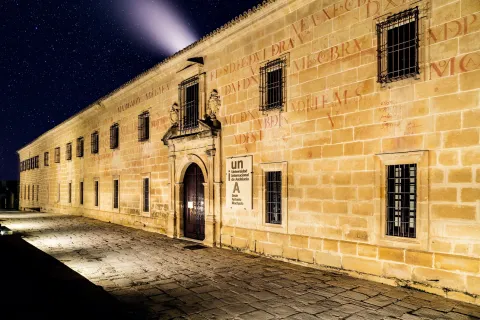
It is the most visited place in the city, the historic heart of the city. It is home to the Old University, the Upper Town Halls, the Fuente de Santa María and the main façade of the Cathedral.
Ubicación
Código Postal
23440
Latitud
37.990400
Longitud
-3.469000
Dirección
Plaza de Santa María
Municipio
Ubicación en el mapa
POINT (-3.469 37.9904)
Tipos de punto de interés
Imágenes carrusel
imagen
Image
catedral-unia-1-jpg
Imagen principal
Desactivado
imagen
Image
unia2-jpg
Imagen principal
Desactivado
imagen
Image
unia-2-jpg
Imagen principal
Desactivado
Imágenes cabecera
imagen
Image
catedral-de-baeza176-1-jpg
Imagen principal
Activado
Loading map
Preparing points of interest and routes...

Constitution Square and City Hall

Submitted by brandcode_deweloper on
Id
6223330
Descripción
Breve descripción

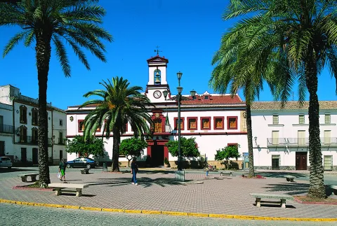
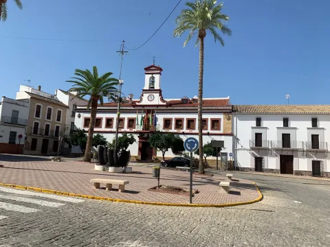
The Plaza de la Constitución collects the three factual powers in a palm of land. The military power is represented by the castle-fortress of the Order of Calatrava of the 13th century. The two towers of the tribute, the Tower of Santa María and the Tower of San Miguel, are erected in its courtyard of arms. The Saint Mary's house is an oratory ordered to be built by the Comandador Juan Pacheco and today it is intended to house the Museum of the Spanish Civil War of the Battle of Lopera that was delivered on the Christmas of 1936. It houses 3543 square meters of surface between its walls and 263 metres of perimeter.

Telecomunicaciones
Sitio web
https://www.lopera.es/
Teléfono de contacto
953 516 250
Correo electrónico
lopera@promojaen.es
Ubicación
Código Postal
23780
Latitud
37.943760
Longitud
-4.214420
Dirección
Plaza de la Constitución, 1
Distrito
Municipio
Ubicación en el mapa
POINT (-4.21442 37.94376)
Tipos de punto de interés
Imágenes carrusel
imagen
Image
Mon001.jpg
Imagen principal
Desactivado
imagen
Image
117444580_1857261887750142_1995693230460379481_o.jpg
Imagen principal
Desactivado
Imágenes cabecera
imagen
Image
IMG_0473.jpg
Imagen principal
Activado
Horario
Monday to Friday: 08: 00 - 15: 00. Saturday and Sunday closed.
Loading map
Preparing points of interest and routes...

Rock Paintings in Santiago-Pontones

Submitted by brandcode_deweloper on
Id
650155
Descripción
Descripción larga

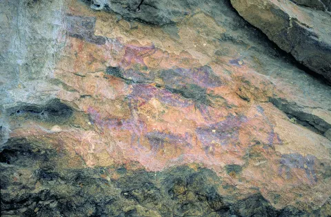
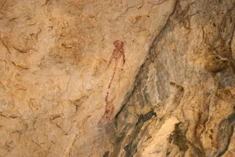
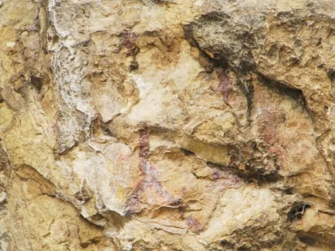
The simple fact of seeing a seed germinate and growing plants, or of observing animals and the birth of women, made these people wonder about the origin of life. These thoughts were those that moved to the walls of the caves as a representation of facts related to daily life and its world of beliefs. We can imagine one of the inhabitants of the Cave of Birth preparing the pigments, mixing them with animal fat, improvising a brush with animal hair and getting ready to paint a scene. I'd be thinking of painting a composition with a hunting scene, fight, dance trying to tell a moment, a scene of life.

The rock paintings represent one of the most important cultural manifestations of prehistory, as they have helped to know some aspects of these societies to learn a little more about their life forms, fauna, flora and the world of their beliefs. What reasons could lead our ancestors to translate the manifestations of daily life and their beliefs into caves and coats? Maybe they were sanctuaries?

Breve descripción

In the saws of Segura and Cazorla there are numerous coats and caves with rock paintings that are part of what is known as the Rupéstre Levino Art and which have been declared a World Heritage Site. We are talking about a very remote time, about 10,000 A.E. We must think of the inhabitants of the Caves of the Engarbo or the Cave of the Birth, for example, the latter being one of the few excavated and allowing to know the passage from Paleolithic to Neolithic. It is a time of great changes in the way of life in which human beings move from being a predator to domesticating vegetables and animals to getting plenty of food and storing it to avoid moving continuously.
Ubicación
Latitud
37.772886
Longitud
-3.788329
Ubicación en el mapa
POINT (-3.788329 37.772886)
Tipos de punto de interés
Imágenes carrusel
imagen
Image
Mon149.jpg
Imagen principal
Desactivado
imagen
Image
Natu149.jpg
Imagen principal
Desactivado
imagen
Image
pinturas_rupestres.jpg
Imagen principal
Desactivado
Imágenes cabecera
imagen
Image
IMG_4324-1.jpg
Imagen principal
Activado
Loading map
Preparing points of interest and routes...

Cánava Pine Forest

Submitted by brandcode_deweloper on
Id
5845162
Descripción
Descripción larga

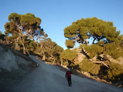
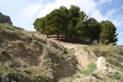
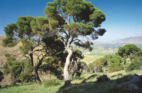
The Pinar de Cánava is an interesting forest ecosystem that has the carrasco pine as its protagonist. The uniqueness of this pineapple, of about 120 copies, is found in its high degree of naturality and, above all, in its longevity, with pine trees between 100 and 250 years old.

This pineapple has great value as an educational resource, as it offers a unique opportunity to understand the different stages of ripening of a forest. In addition, the appearance of a pine can be observed at a stage near old age. In front of the typical forms of young pineapples with straight trunks and conical cups, they contrast the twisted specimens of this Natural Monument. Its rounded, parasol-shaped cups remind of other tree species. The bush in this forest has almost disappeared. This complex aspect is the one that every forest would have in a natural way, but man's intervention changes this process, tending towards greater simplicity.

Breve descripción

Protected natural space, as a natural monument, of 5 ha of extension. The municipal term of Jimena. Interesting pine that shows the relish vegetation, ancient of the area. We could consider it a plant landscape, witness to ancient vegetation.

Ubicación
Nombre
Cerro de la Atalaya
Latitud
37.841470
Longitud
-3.478850
Distrito
Municipio
Ubicación en el mapa
POINT (-3.47885 37.84147)
Tipos de punto de interés
Imágenes carrusel
imagen
Image
image_248193.jpeg
Imagen principal
Desactivado
imagen
Image
imagen-166-pinar-jpg
Imagen principal
Desactivado
Imágenes cabecera
imagen
Image
Monumentos_naturales_2%20%281%29.jpg
Imagen principal
Activado
Microsite al que pertenece
Loading map
Preparing points of interest and routes...

Drinking Trough Fountain

Submitted by brandcode_deweloper on
Id
910704
Descripción
Descripción larga

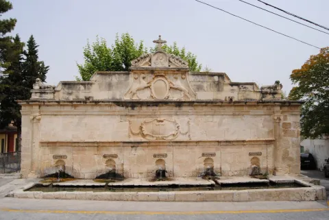
Precisely, to the cloister of the said convent, Mr Gonzalo Messía Carrillo Fonseca, I Marqués de La Guardia, commissioned the execution of an exempt fountain, crowned by the Magdalena and dated 1577, which has been attributed to Francisco del Castillo "El Mozo," currently located in the courtyard of the Excel. Provincial Council of Jaén. Years earlier, and perhaps to commemorate the appointment as I Marqués de La Guardia, Gonzalo Messía ordered to raise a pilar-abrevadero at the entrance of the population, near the Dominican convent, to serve as a water supply to the neighbors and their animals. This beautiful space, threatened with splendid gardens, over time became a plateau made up of the source itself and a nobility house of silery built according to the date of 1814.

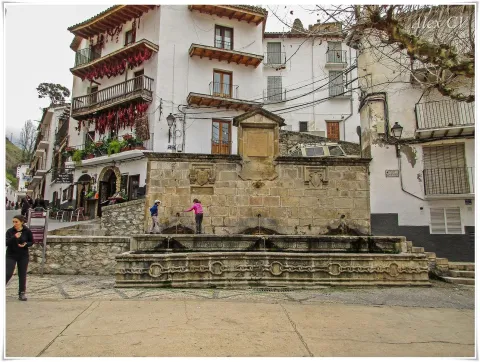
The pilar-abrevadero, in a landscape and built of silary stone, is formed by a wall articulated by two bodies and attic. In the first body there are five caños of bronze out of avenerated hornazas that pour abundant waters on a rectangular pillar, in the second a beautiful frame was carved with hanging cloth with the inscription allusive to the comitant and the date of execution: "This work command to do the Iltmo. Mr. Don Gonzalo Mexia Carrillo, my lord. Year 1566." Throughout this second body there is an internment supported at the ends in Ionian striated columns. In the center of the attic two canes, with the garruches of the Messia family, hold an oval shield on the mould with the crown of Marquis and the following inscription "Plaza de Isabel II Reina Constitucional," with which this place has been known since. In its origin the dogs held the shield with the weapons of Don Gonzalo Messia Carrillo; it is overcome with a fronton with a central relief flanked by fins and crowned with a Cross, to the ends and bearing the cross of Santiago have settled two lying lions (all very redone).

Although the tracist of this beautiful pillar is not known, the stylems incorporated in it, columns with alternating sticks, the scroll with cloth (similar to the carved ones in the City Palace of Ubeda), the molding of the inlet and the cut-off hides of the shield held by the canes point to a possible intervention by Andrés de Vandelvira. Professor Galera Andreu expresses himself in this respect: I do not believe that the public source is not at his hand, despite the reforms (...) to be highlighted by the small scale of the columns attached in an application to the reverse of what was done in the chapel of the Benavides in Baeza. The set was restored by the local workshop school in 1991.

Breve descripción

Monument of the Historical-Artistic Set. Declared 06 / 07 / 1983 To the Messies, lords and Marquis of La Guardia, the architectural wealth preserved in this villa is largely due. Thanks to its performance, not without taste, the old Bajomieval fortress adapted to the new palaciegos (typical of the reign of the Catholic Kings) with a beautiful tarootic cover and encouraged the foundation of a convent run by the Dominicans, in which consecrated architects such as Andrés de Vandelvira and Francisco del Castillo "El Mozo" would intervene throughout the 16th century.

Telecomunicaciones
Sitio web
www.laguardiadejaen.com/tu-ciudad/historia/
Teléfono de contacto
953 327 100
Correo electrónico
ayuntamiento@laguardiadejaen.es
Ubicación
Código Postal
23170
Latitud
37.744720
Longitud
-3.693890
Dirección
C/ Escuelas, 11
Distrito
Ubicación en el mapa
POINT (-3.69389 37.74472)
Tipos de punto de interés
Imágenes cabecera
imagen
Image
Pilar%20Abrevadero%20%281%29.jpg
Imagen principal
Activado
Loading map
Preparing points of interest and routes...

"Los deseos" Stone

Submitted by brandcode_deweloper on
Id
1476792
Descripción
Descripción larga

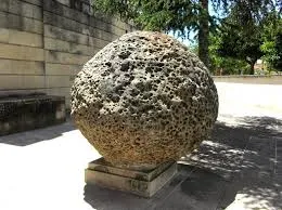
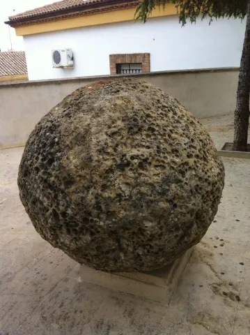
If we look at it from the geological point of view, it is a sphere of sandstone / limestone, which is very eroded by having been buried along with strong water currents, which have contributed to forming an countless number of holes along its entire surface, giving it even more if that character of lunar appearance is there. Leaving aside its geological nature and approaching its symbolic nature, we can say that it is a ritual or sacred stone as we have previously called it, whose name within the archaeological argot is Betilo. This type was used by prehistoric sedentary communities near the Neolithic. Its value was ceremonial or ritual, as they were considered to be divinities associated with the fertility of the land or of the woman. This type of betils were usually placed around the primitive sanctuaries or houses / caves of the community leader and around it were held rituals.

In the case of our "Stone of the Desires," we find that at the top, it has an orifice of deep broth, the purpose of which was to bear the pagan divinities once they take human figure, or later for the Christian communities to place the cross, an unequivocal symbol of Christianity.
This sphere reached Arjona in 1995, a year of terrible drought, in which the fields of Arjona offered a desolate aspect. The same day that the stone arrives in Arjona, a great storm is unleashed that changes the look of these fields, which have been damaged by the terrible drought that has been in this town for months. It is curious how the power of this stone was quickly associated with rituals of Mediterranean cultures that have water as the main rite. That water that makes the earth fertile, that you water the fields and that gives life to the crops, offers us the enigmatic aspect of this stone, whose ancestral function for which it was created, was to symbolize the fertility of the earth, fertility that is achieved only by rain, in this case and thousands of years later the stone exercises that same symbolic power just after reaching its new destination, Arjona.

In the nights of San Juan there are numerous Arjoneros, who come to this stone to practice rituals specific to Mediterranean culture. But this stone not only works on the night of San Juan, from its location in or privileged place of the Plaza de Santa María, is available to the visitor and Arjonero any day of the year. For the visitor's wishes to be fulfilled, in Arjona we have devised a ritual to follow. This ritual consists of placing the 5 fingers of either of the two hands, in holes of similar size, once this ritual has been performed a desire is asked.
From here we want our "Stone of the Desires" to grant you health and happiness.

Breve descripción

This enigmatic sphere, which in Arjona is popularly known as "La Piedra de los Deseos" or "Las Casualidades," was incorporated into the city of Arjona in 1995. Despite these "titles" with which the stone currently counts or is known, it is a bethyl or sacred stone. This type of "Sacred Stone," comes from an excavation that took place in the ancient Gothic Cathedral of Jaén, which reaches Arjona by the hands of our illustrious countryman Juan Eslava Galán.

Telecomunicaciones
Sitio web
www.redjaen.es
Ubicación
Código Postal
23760
Latitud
37.935360
Longitud
-4.054280
Dirección
C/ Santa María, 7
Distrito
Municipio
Ubicación en el mapa
POINT (-4.05428 37.93536)
Tipos de punto de interés
Imágenes carrusel
imagen
Image
Piedra%20de%20Los%20Deseos.jpg
Imagen principal
Desactivado
Imágenes cabecera
imagen
Image
Piedra.jpeg
Imagen principal
Activado
Loading map
Preparing points of interest and routes...

Peaks of the Guadiana

Submitted by brandcode_deweloper on
Id
913424
Descripción
Descripción larga

The Guadiana Menor is a very young river from the geological point of view. Until about 10,000 years ago, its basin was a large salty lake, to which it provided its waters and sediments numerous streams from Sierra Nevada, Filabres and the Macizo de Cazorla and Segura. Its current course arose in an accidental and violent way, perhaps due to the breaking of one of the margins of the lake produced by an earthquake, excavating deep ravines, leaving out the yermas clays, loaded with plaster and salts, rolling edges and marine sands, a means that makes it difficult to survive the living beings that inhabit them.

The depression that bears its name from this river is the most arid area in the province and one of the driest in Europe, recording annual rainfall that very rarely exceeds 250 mm. The consequence is that of a semidesertic, rotational and beautiful landscape, populated by highly specialized Stepparian vegetables to the middle, most herbs and small matas. Its biological uniqueness is enormous, having an endemic character (very small geographical area) more than half of the species present in the area. This proportion is only comparable to the biological exclusivity of the high betic mountain, where we find most of the most well-known endemisms in the Natural Park.

We suggest...

  • Make the Desert Route, described in the Tourist Guide of Hinojares.
  • Visit the Mirador del Lirio, with stunning views of the valley and the desert of the Natural Park. It is accessed (it is signposted) from the village of Fontanar, which is located about 5 Km from Pozo Alcón.
  • Other unique points of this recommended visit are the necropolis ibera de los Castellones de Ceal, next to the village of Ceal, and the Salinilla de Chillar, located very close to Hinojares.

To visit the Picos del Guadiana and to visit the subdesert area of the Natural Park that corresponds to the Valle del Guadiana Menor, we will use the road section of the A-315 that links Bone with Pozo Alcón and Hinojares. The view of the Picos is at the beginning of these, in an enranche of the previous way, about 14 km from Hinojares and 19 km from Pozo Alcón.

Breve descripción

The geoforms of the valley of the Minor Guadiana, originating from the slow and inexorable erosive processes, are extremely striking. An enclave of great geomorphological interest, proposed as a natural monument: the Picos del Guadiana, stands out. It is a limestone crest where the petreous strata, arranged vertically, emerge from a cone of soft clays, forming a rocky alignment that resembles the teeth of a saw. The most imaginative say that it is the fossil of a colossal dinosaur that died by the river, without considering that there was no such channel in the Jurassic and that some of those prehistoric animals were huge, but not so much.

Ubicación
Latitud
37.702695
Longitud
-2.935057
Municipio
Ubicación en el mapa
POINT (-2.935057 37.702695)
Tipos de punto de interés
Imágenes carrusel
imagen
Image
picos.jpg
Imagen principal
Desactivado
Imágenes cabecera
imagen
Image
8040409Master.jpg
Imagen principal
Activado
Loading map
Preparing points of interest and routes...

Peaks of the Guadiana

Submitted by brandcode_deweloper on
Id
2980258
Descripción
Descripción larga

We are located in the subdesert area near the Natural Park Sierras de Cazorla, Segura and Las Villas. The geoforms of the valley of the Minor Guadiana, originating from the slow and inexorable erosive processes, are extremely striking. An enclave of great geomorphological interest, proposed as a natural monument: the Picos del Guadiana, stands out. It is a limestone crest where the petreous strata, arranged vertically, emerge from a cone of soft clays, forming a rocky alignment that resembles the teeth of a saw. The Guadiana Menor is a very young river from the geological point of view. The depression that bears its name is the driest area in the province and one of the driest in Europe, recording annual rainfall that very rarely exceeds 250 mm. Its biological uniqueness is enormous, having an endemic character (very small geographical area) more than half of the species present in the area.

Breve descripción

We can access this peculiar landscape through the A-315 road that links Bone with Pozo Alcón and Hinojares. The view of the Picos del Guadiana is located in a corner of the previous track, about 13 km. from Hinojares and 19 from Pozo Alcón.

Ubicación
Código Postal
23487
Latitud
37.747960
Longitud
-3.099540
Dirección
Carretera A-315
Municipio
Ubicación en el mapa
POINT (-3.09954 37.74796)
Tipos de punto de interés
Imágenes carrusel
imagen
Image
picos_guadiana.jpg
Imagen principal
Desactivado
Imágenes cabecera
imagen
Image
10463723Master.jpg
Imagen principal
Activado
Loading map
Preparing points of interest and routes...