Columpio Gigante de Torres – Ravine ofl Arroanduelo – Portillo de la Zarzadilla
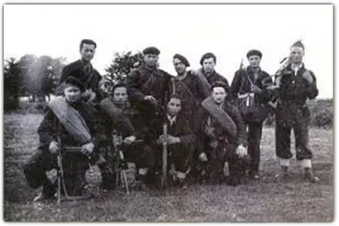
The Civil War unevenly affected the province of Jaén, which remained in the Republican area until 28 March 1939, almost the end of the War. In many municipalities, agricultural communities had been implemented and some initiatives had been abruptly interrupted after the end of the war. As was the case during the Napoleonic invasion, these saws facilitated the emergence of groups of armed resistance, known as maquis. Some of his family and friends always tried to help them, at the risk of reprisals for collaborating with the guerrilla.
In the Sierra de Segura, he highlighted Sixto García Espinosa, "that of Marchena," who led a group that resisted until 1950 in caves near the village of Marchena, near Santiago de la Espada, of which José Antonio Fernández, from the village of Miller, Juan Sáez, who was mayor of the neighbouring municipality of Nerpio, and Manuel Romero, secretary of the same municipality. They were all killed or arrested by the Civil Guard.
Another of the resistors was Pablo, that of Motril, although it was actually called Manuel Pérez Rubiño, who focused his activity until 1952 on the terms of Cazorla, Quesada and Pozo Alcón. Other names that have remained in the collective memory are those of "Fernandillo" or the "Red Terrinches," which now become known thanks to the latest historical investigations and the attempt to recover the historical memory of the period immediately after the Civil War.
In 2007 Quesada designed 11 itineraries in which the time of the Maquis was interpreted and made known and their presence in the mountains of Cazorla and Segura recovering ancient paths, caves, natural shelters and cortijos by which the Maquis walked in an attempt to recover a chapter of our most recent history.
Path PR-A 414 River Velillos (10.4 km).
The uniqueness of this linear route is that through the river Alcalá la Real and Vega granadina communicated, making it a strategic area of the Sierra Sur de Jaén, throughout its history.
The path that begins in the village of Ribera Alta, for the most part on roads and paths, near or on the margins of the Salobral stream, the Palanantia stream and above all on the banks of the river Velillos, which we will be forced to cross on several occasions. The fountain of the Bath Cortijo will help us to refresh, before it takes some height to enjoy a great view of the river and up the Ribera Alta. Friars and the hill of the Martina at the bottom and looking down at the village of Ribera bajo.
On the bridge next to Tahona, we arrive to the Baja Bank, small pedanía of Alcalá la Real, where the landscape is made up of 800 and 900 meters covered with olive trees, and in the low parts cereal crops. It is here that the river crosses the town side by side, with a magnificent Vega and some choperas or small wires, which give it a picturesque image and a refreshing climate.
With this path approved by the National Mountain Federation, you will discover the natural heritage of the municipality. He walks by the river Velillos and discovers the importance of water in a land characterized by dry crops. It walks between olive trees, cereal, wire and choperas and is in a unique environment, discovering the pedanias of Ribera Alta and of Ribera Baja, in which the river has shaped the distribution of its population since Roman times.
Just after leaving Pegalajar, you can reach a small mountain port, a portillo known as Seven Pillas, between the Serrezuela de Pegalajar and the massif of Sierra Magina. In this place, favored by winds is the paragliding area of the same name.
The few 7 km that link Paste with Manchar Real (Ctra. JA-3203) are those of a small road that hangs from the skirts of Sierra Magina, and are a magnificent lookout towards the countryside and the city of Jaén. Mancha Real runs through the center of its urban centre. This industrial and olive-growing town has a beautiful Renaissance church, the Church of the Holy Cross, which well deserves a stop.
The stretch between Mancha Real and Torres (Ctra. JA-3106) shows a good view of Sierra Magina. The arrival in Torres offers one of the best landscapes of the Natural Park. A high mountain horizon, which in its skirts collects the orchards and cherry plantations that reach the urban town of Torres hanging from Mount Aznaitín. The Marquis de Camarasa palace, the climbing in the Cimbras, some of its restaurants are sufficient reasons to devote a while to this town. It is highly recommended to walk to the clock that crowns the population and that in an unknown viewpoint teaches the best of these mountains.
But the best thing is to come. The mountain road between Torres and Albanchez de Mágina (JA-1107) is so small that these two villages separated by only 10 km do not enjoy a bus line... because there is no commercial-sized bus that can travel some points on this road. The main attraction is the landscape, which leads from the moist north side to the driest east, always accompanied by cherry and olive plantations.
Albanchez de Magina, has a rocky castle of must visit, as well as the need to try the almonds, cupcakes and bread, for many the best in the province of Jaén.
7 kilometers (Ctra. JA-3105) more and you will reach Jimena and the A-320 road. In Jimena you can ask about the wheat potage, and you have to visit the Cueva de la Graja, with interesting neolithic rock paintings (access is by a steep path that begins in the municipal pool). The city hall will provide you with the instructions and key to visit the cave. If your pass through Jimena is at the beginning of the summer, look for the best brews in Andalusia that are collected here by the local cooperative.
In the direction of Jaén@-@ Mancha Real, for the Ctra. A-320, just two kilometers away you will find the right turn that will take you to the village of Garciez, always on a road (A-6104) that immerses you in the olive grove for five km.
Garciez and his Renaissance palace of the Marquis de Viana are a surprise. The palace is not visitable, but only the outside walk gives an idea of importance of the place in the 16th century.
Seven more miles and you'll be in Bedmar. This town has restaurants and bars for food, as well as a ruined castle hanging over the village. In this town is the seat of the Regulatory Council of the Denomination of Origin of Extra Virgin Oil Sierra Magina, which orders the production of one of the best oils in Jaén.
This route by car involves a visit to different areas of Sierra Magina. Although it is recommended for any time of year, autumn, but especially spring are the best time to make this visit.
The route begins in Pegalajar, town of the Guadalbullón River, with different points of interest, such as its traditional medieval garden system or rural accommodation in cave houses
Distance: 55 km.
Time approx.: 1 and a half hours (not including stops).
One of these routes starts right above the Almond Quarter, at the junction of the Circumvalation Road with the rise to the Castillo-Parador de Turismo. Towards the south side of the hill of the Castle of Santa Catalina, next to the road of ascending to the Castilla-Hospital El Neveral, a narrow path rises between almonds under the vertical walls that serve as foundations to the walls of the castle. The itinerary presented here has the possibility of being extended with other surrounding areas.
We will pass to a water tank and then we will enter the pine until we leave to a crossing of the road right next to the Caño Quebrado fountain. From the back of the forest house in this Source continues a path parallel to the road. We followed her until we crossed the track next to the El Neveral Recreative Zone. We continue on the path that goes up between the pine and the olive grove, overlooking the Hospital of El Neveral, and pass by another water tank, until we reach a clear area of trees from where we will see a closed curve a crossing and continue to glide and leave the crossing to the right and another to the left. We will connect with a track that, after, a small climb that places us at more than 1000 meters of height, just below the Cerro de los Morteros, descends to the previous recreational area, culminating the circular stretch of this path and then continuing on the road already travelled to the fountain of Caño Quebrado, at the crossing with access to the Castle.
Right next to this crossing, in front of the Fountain is taken a descending lane to the north side and to the city of Jaén, which immediately becomes a path from which we will enjoy beautiful views of the city through the pines. We had a small olive tree and crossed the wall of Almohad origin (11th century). In this area, in the direction of the decks of the Cross of the Castle, through the wall through the door there, there are some scarves that have traditionally been the school of the Jiennese climbers. By a final stretch of the downhill track we will go to the Circumvalation Road, already in the Magdalena district, again in the city of Jaén.
Recently, hiking routes (PR-A 126 and 127) have been identified in the immediate mountains to the city of Jaén, in particular in the Periurban Park of the Neveral and Castle of Santa Catalina, which is mostly made up of a magnificent forest of Pinus halepensis and rocky areas. This tour is sometimes used by athletes from the capital, for hiking, all-terrain bike, trial bike, mountain race and climbing. This is an area of environmental value that offers resources for the practice of different activities.
Circular.
Length: 6 Km.
Difficulty: Low / medium.
We take the track that leaves next to the Hall of Nature in the direction of Llanos de Palomares; about 1 Km we will find a crossing where an indicator tablet points a 4x4 route to the village of Cárchel (same beginning as on the route of the Cross of the Chimba). We take the right track, cut with a chain, and after walking about 500 meters in a closed curve, a path that is introduced into a pipe and ends in the Pocicco hill is left. We leave the track and take that path. We'll soon find a fork and take the left path. The road passes between a dense pine and after overcoming a slightly steep slope stretch, it leaves the forest area. A few meters away you will find the Matamulos Crest and the point of the same name (1256 m). From there the mountain is almost minced to the Quiebrajano River. We have magnificent views of the reservoir and all the saws of the area. If we grow to our right we will reach the Cueva del Montañés, at the same summit of the Matamulos. The views of the valley and the Garganta de los Thieves are impressive.
From there we will return in the opposite direction to the Llanos de Palomares until we take the track that will bring us back to the Cañada de las Hazadillas by the head of the valley. In case of doubt it is recommended to return for the same one-way route.
Vehicle approach from the Quebrajano Road to the Hazadillas Canyon. One of the paths to know in depth the Parque Periurbano Monte de la Sierra.
Circular.
Approximate distance: 8.5 Km.
Difficulty: Low. Average on the ridge.
We take a track that goes up the ravine of Estoril and after leaving to our left a huge rocky coat, in which there are curious prehistoric engravings with geometric shapes, we go out to a valley dominated by the castle of Otiñar. There comes a sidewalk that, after entering a narrow throat, rises with a strong slope all over the ravine of the Hoya del Caño. We ignore all the detours to the left and right and pass by the Bishop's source. After a very hard rise in some sections the sidewalk, which passes almost all the time on the right side of the ravine in the sense of ascension, we are located in the Llanos de las Navas, beautiful enclave more than 1500 m high where the forest of lush pine trees with fresh meadows is altered. In winter it is not uncommon to find them snowy. To get here, we'll need about three hours and a lot of physical effort.
The plains are taking a slope to the side of the Pandera, which we have in front of us. In the upper area, on its eastern side, there is a cave disguised by a huge rock that is in front of its entrance. Right on the top of this cave, which serves as a shelter for pastors and mountaineers, a path begins that, through a rocky high mountain terrain will lead us in an hour and a half more to the summits of the Pandera. The sidewalk, which must be located by reference to the cave, is clearly marked at first, as it takes place by opening way between low mountain, but we will have to pay attention to not lose it as we gain height. In days of low visibility or bad weather it is risky to venture to the summit. We will unwind in a vaguada that forms between the Peña del Altar (1809 m) on our left, and the Alta de La Pandera (1870 m) on our right. In addition to this last summit, there are old military facilities. In the Peña del Altar we will see two small constructions: a fire guard house and a small open shelter that is used by the mountaineers for overnight stay. The views from Peña del Altar are spectacular. Its rocky cliffs fall to the Quebrajano. We are at the highest point in the entire South Sierra de Jaén. Much of the province of Jaén and Granada is seen from here. The countryside and the Guadalquivir Valley after the Sierra de Jabalcuz to the north, the peaks of Sierra Magina and the Sierras de Cazorla, Segura and the Villas to the east and to the south and west all the bethic mountain system, with the backdrop of the Sierra Nevada mountain range.
The descent will have to be realized by returning to our steps. In winter time, we will have to be careful of the slippery ice-cream snowers that we can find in this area of darkness. There is an alternative that the end of the tour will be made to the road from Los Villares to Valdepeñas, in the area known as Arroyo Frio, which will require coordination with a second vehicle that would be left in this area previously. In any case it is a route that requires practice in the orientation, as to this point would still have to go several kilometres of paths, with the use of cartography, and even the current guidance systems with browser and / or GPS, being recommended. This stretch, in the reverse sense, is explained in more detail in the section of the Sierra Sur, clicking on the path Puerto de la Hoya.
The beginning is at the Km 14 of Jaén to the Embalse del Quiebrajano, next to the so-called Casa del Pintor (house with green graffiti on the walls), in the vicinity of the road crossing between the Cañada de las Azadillas and the Embalse del Quiebrajano.